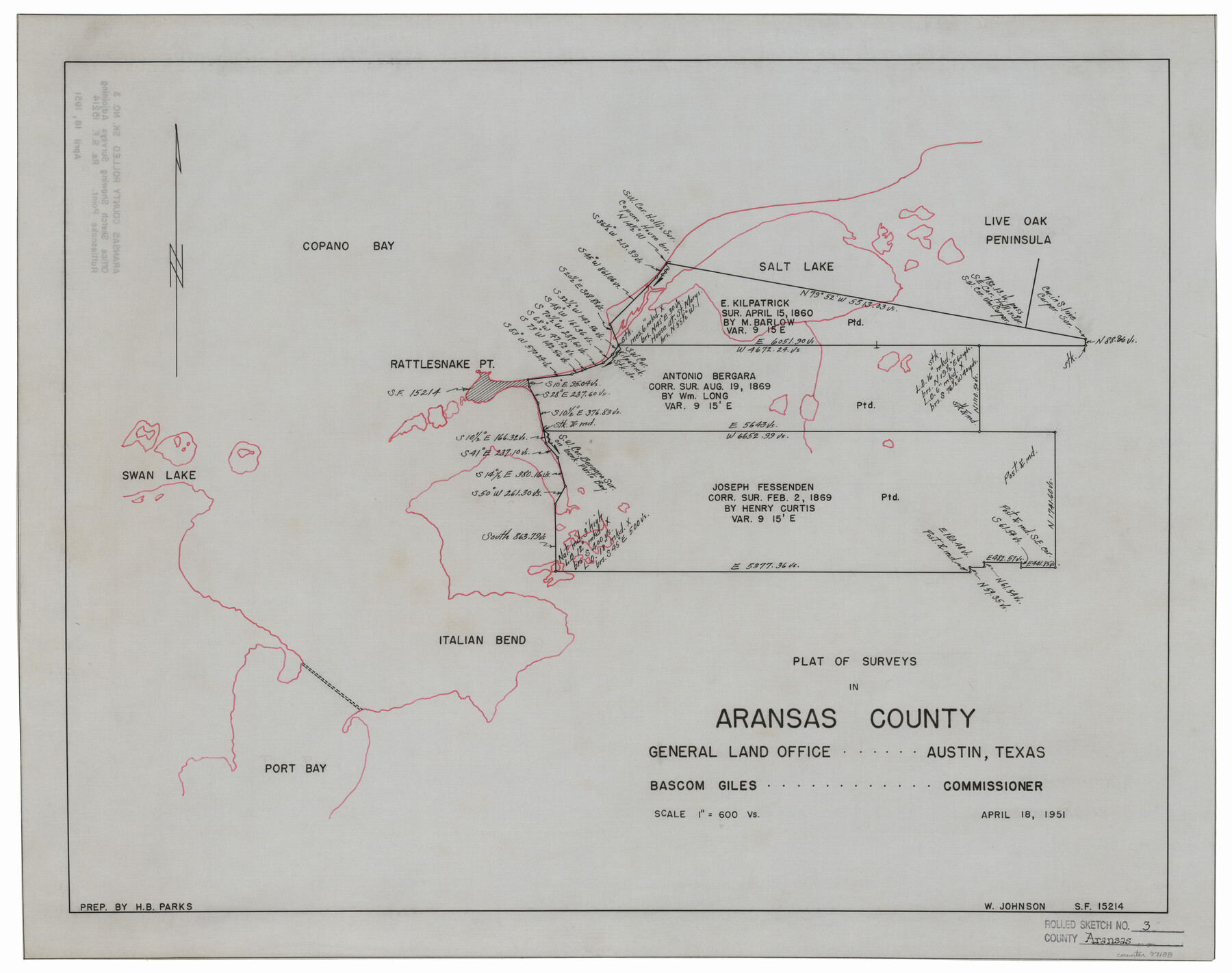
Aransas County Rolled Sketch 3
[Office sketch showing surveys adjoining Rattlesnake Point re: SF 15214]
-
Map/Doc
77188
-
Collection
General Map Collection
-
Object Dates
1951/4/18 (File Date)
-
People and Organizations
Bascom Giles (GLO Commissioner)
H.B. Parks (Draftsman)
-
Counties
Aransas
-
Subjects
Surveying Rolled Sketch
-
Height x Width
20.9 x 26.5 inches
53.1 x 67.3 cm
-
Medium
linen, manuscript
-
Scale
1" = 600 varas
Part of: General Map Collection
Loving County Working Sketch 21

Print $20.00
- Digital $50.00
Loving County Working Sketch 21
1984
Size 26.7 x 36.0 inches
Map/Doc 70655
Nueces County Rolled Sketch 35

Print $20.00
- Digital $50.00
Nueces County Rolled Sketch 35
1910
Size 33.6 x 24.3 inches
Map/Doc 6877
Map of Atascosa Co.

Print $40.00
- Digital $50.00
Map of Atascosa Co.
1894
Size 48.3 x 46.6 inches
Map/Doc 4877
El Paso County Rolled Sketch 43B

Print $20.00
- Digital $50.00
El Paso County Rolled Sketch 43B
Size 22.0 x 22.0 inches
Map/Doc 5830
Flight Mission No. CUG-3P, Frame 162, Kleberg County

Print $20.00
- Digital $50.00
Flight Mission No. CUG-3P, Frame 162, Kleberg County
1956
Size 18.5 x 22.3 inches
Map/Doc 86282
Brewster County Rolled Sketch 101

Print $40.00
- Digital $50.00
Brewster County Rolled Sketch 101
1927
Size 74.2 x 42.3 inches
Map/Doc 9192
Walker County Working Sketch 6

Print $20.00
- Digital $50.00
Walker County Working Sketch 6
1935
Size 30.8 x 40.6 inches
Map/Doc 72286
Reagan County Working Sketch 27

Print $20.00
- Digital $50.00
Reagan County Working Sketch 27
1960
Size 33.0 x 42.5 inches
Map/Doc 71869
Location of the Southern Kansas Railway of Texas

Print $40.00
- Digital $50.00
Location of the Southern Kansas Railway of Texas
1887
Size 18.6 x 106.9 inches
Map/Doc 64181
[Gulf Coast of Texas]
![72702, [Gulf Coast of Texas], General Map Collection](https://historictexasmaps.com/wmedia_w700/maps/72702.tif.jpg)
Print $20.00
- Digital $50.00
[Gulf Coast of Texas]
1881
Size 28.6 x 18.2 inches
Map/Doc 72702
[Beaumont, Sour Lake and Western Ry. Right of Way and Alignment - Frisco]
![64133, [Beaumont, Sour Lake and Western Ry. Right of Way and Alignment - Frisco], General Map Collection](https://historictexasmaps.com/wmedia_w700/maps/64133.tif.jpg)
Print $20.00
- Digital $50.00
[Beaumont, Sour Lake and Western Ry. Right of Way and Alignment - Frisco]
1910
Size 20.0 x 45.5 inches
Map/Doc 64133
Flight Mission No. DCL-4C, Frame 146, Kenedy County

Print $20.00
- Digital $50.00
Flight Mission No. DCL-4C, Frame 146, Kenedy County
1943
Size 18.6 x 22.3 inches
Map/Doc 85824
You may also like
Jefferson County Sketch File 48

Print $20.00
- Digital $50.00
Jefferson County Sketch File 48
1875
Size 19.8 x 21.0 inches
Map/Doc 11882
Refugio County Working Sketch 13

Print $20.00
- Digital $50.00
Refugio County Working Sketch 13
1961
Size 23.8 x 29.8 inches
Map/Doc 63522
El Paso County Working Sketch 35

Print $20.00
- Digital $50.00
El Paso County Working Sketch 35
1977
Size 19.8 x 30.3 inches
Map/Doc 69057
Denton County Sketch File 4

Print $6.00
- Digital $50.00
Denton County Sketch File 4
1858
Size 12.2 x 7.9 inches
Map/Doc 20690
Chambers County Rolled Sketch 8

Print $20.00
- Digital $50.00
Chambers County Rolled Sketch 8
Size 39.8 x 30.5 inches
Map/Doc 8612
Armstrong County Sketch File A-10

Print $40.00
- Digital $50.00
Armstrong County Sketch File A-10
Size 22.6 x 35.6 inches
Map/Doc 10852
Flight Mission No. CUG-2P, Frame 21, Kleberg County

Print $20.00
- Digital $50.00
Flight Mission No. CUG-2P, Frame 21, Kleberg County
1956
Size 18.5 x 22.3 inches
Map/Doc 86185
Orange County Working Sketch 50

Print $20.00
- Digital $50.00
Orange County Working Sketch 50
1991
Size 36.0 x 43.6 inches
Map/Doc 71382
Burnet County Boundary File 5

Print $16.00
- Digital $50.00
Burnet County Boundary File 5
Size 12.7 x 7.9 inches
Map/Doc 50878
Lynn County Sketch File 22

Print $2.00
- Digital $50.00
Lynn County Sketch File 22
1994
Size 11.1 x 8.8 inches
Map/Doc 30553
Nueces County Rolled Sketch 59

Print $20.00
- Digital $50.00
Nueces County Rolled Sketch 59
1979
Size 38.8 x 27.7 inches
Map/Doc 6906
English Field Notes of the Spanish Archives - Book 5

English Field Notes of the Spanish Archives - Book 5
1835
Map/Doc 96531