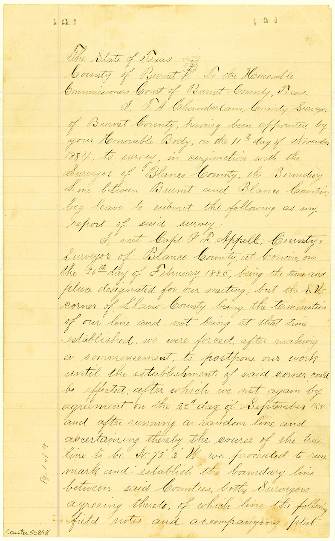
Burnet County Boundary File 5
Surveyors Report on Burnet and Blanco County Line
-
Map/Doc
50878
-
Collection
General Map Collection
-
Counties
Burnet
-
Subjects
County Boundaries
-
Height x Width
12.7 x 7.9 inches
32.3 x 20.1 cm
Part of: General Map Collection
Flight Mission No. DAH-9M, Frame 157, Orange County

Print $20.00
- Digital $50.00
Flight Mission No. DAH-9M, Frame 157, Orange County
1953
Size 18.5 x 22.5 inches
Map/Doc 86856
[Surveys along the Trinity River]
![321, [Surveys along the Trinity River], General Map Collection](https://historictexasmaps.com/wmedia_w700/maps/321.tif.jpg)
Print $2.00
- Digital $50.00
[Surveys along the Trinity River]
Size 3.6 x 3.7 inches
Map/Doc 321
Travis County Working Sketch 30

Print $20.00
- Digital $50.00
Travis County Working Sketch 30
1963
Size 30.5 x 35.1 inches
Map/Doc 69414
Schleicher County Sketch File 20

Print $20.00
- Digital $50.00
Schleicher County Sketch File 20
1936
Size 16.8 x 17.4 inches
Map/Doc 12301
Hopkins County Working Sketch 1

Print $20.00
- Digital $50.00
Hopkins County Working Sketch 1
1951
Size 24.1 x 19.0 inches
Map/Doc 66226
[Corpus Christi Bay, Padre Island, Mustang Island, Laguna de la Madre, King and Kenedy's Pasture]
![73045, [Corpus Christi Bay, Padre Island, Mustang Island, Laguna de la Madre, King and Kenedy's Pasture], General Map Collection](https://historictexasmaps.com/wmedia_w700/maps/73045.tif.jpg)
Print $20.00
- Digital $50.00
[Corpus Christi Bay, Padre Island, Mustang Island, Laguna de la Madre, King and Kenedy's Pasture]
Size 26.6 x 18.1 inches
Map/Doc 73045
Hemphill County Rolled Sketch 15B

Print $20.00
- Digital $50.00
Hemphill County Rolled Sketch 15B
1961
Size 26.7 x 17.0 inches
Map/Doc 6196
Harris County Historic Topographic 19

Print $20.00
- Digital $50.00
Harris County Historic Topographic 19
1915
Size 29.3 x 22.6 inches
Map/Doc 65830
Dimmit County Boundary File 4

Print $14.00
- Digital $50.00
Dimmit County Boundary File 4
Size 14.1 x 8.8 inches
Map/Doc 52570
Flight Mission No. DIX-7P, Frame 24, Aransas County

Print $20.00
- Digital $50.00
Flight Mission No. DIX-7P, Frame 24, Aransas County
1956
Size 18.6 x 22.6 inches
Map/Doc 83876

Refugio County Rolled Sketch 5

Print $20.00
- Digital $50.00
Refugio County Rolled Sketch 5
1941
Size 45.0 x 42.5 inches
Map/Doc 9859
You may also like
Kinney County Working Sketch 51

Print $20.00
- Digital $50.00
Kinney County Working Sketch 51
1980
Size 34.6 x 47.2 inches
Map/Doc 70233
Trinity River, South Extension Porters Bluff Sheet

Print $20.00
- Digital $50.00
Trinity River, South Extension Porters Bluff Sheet
1925
Size 16.3 x 24.4 inches
Map/Doc 69690

Hays County Sketch File AB

Print $16.00
- Digital $50.00
Hays County Sketch File AB
1891
Size 6.3 x 8.7 inches
Map/Doc 26189
Navasota and Grimes County, Texas

Navasota and Grimes County, Texas
Size 25.8 x 28.5 inches
Map/Doc 96865
Lampasas County Boundary File 3a

Print $8.00
- Digital $50.00
Lampasas County Boundary File 3a
Size 13.2 x 8.2 inches
Map/Doc 56106
Henderson County Working Sketch 4

Print $20.00
- Digital $50.00
Henderson County Working Sketch 4
1918
Size 21.2 x 16.0 inches
Map/Doc 66137
Hansford County

Print $20.00
- Digital $50.00
Hansford County
1889
Size 22.9 x 18.5 inches
Map/Doc 3624
Palestine, Texas

Print $20.00
- Digital $50.00
Palestine, Texas
1942
Size 39.3 x 36.1 inches
Map/Doc 4834
Hardin County Sketch File 35

Print $24.00
- Digital $50.00
Hardin County Sketch File 35
Size 9.2 x 8.4 inches
Map/Doc 25175
Calhoun County Rolled Sketch 13

Print $20.00
- Digital $50.00
Calhoun County Rolled Sketch 13
1948
Size 43.0 x 41.0 inches
Map/Doc 8547
McLennan County

Print $20.00
- Digital $50.00
McLennan County
1872
Size 16.3 x 21.9 inches
Map/Doc 3863