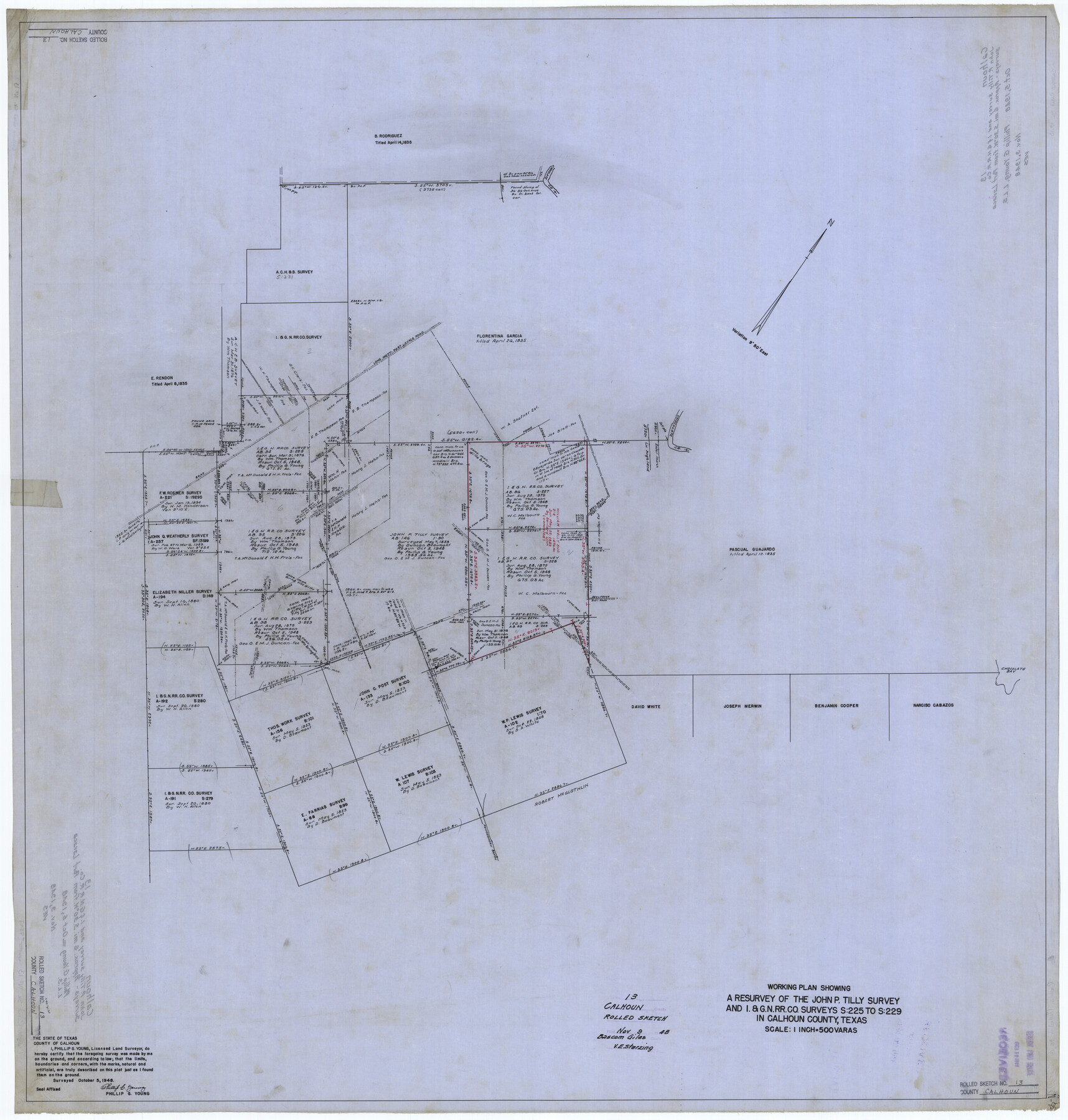
Calhoun County Rolled Sketch 13
Working plan showing a resurvey of the John P. Tilly survey and I. & G. N. R.R. Co. surveys S:225 to S:229 in Calhoun County, Texas
-
Map/Doc
8547
-
Collection
General Map Collection
-
Object Dates
1948/10/5 (Creation Date)
1948/11/9 (File Date)
-
People and Organizations
Phillip G. Young (Surveyor/Engineer)
-
Counties
Calhoun
-
Subjects
Surveying Rolled Sketch
-
Height x Width
43.0 x 41.0 inches
109.2 x 104.1 cm
-
Medium
linen, manuscript
-
Scale
1" = 500 varas
Part of: General Map Collection
Runnels County Working Sketch 9

Print $40.00
- Digital $50.00
Runnels County Working Sketch 9
1948
Size 48.8 x 30.1 inches
Map/Doc 69712
[Gulf Coast of Texas]
![72704, [Gulf Coast of Texas], General Map Collection](https://historictexasmaps.com/wmedia_w700/maps/72704.tif.jpg)
Print $20.00
- Digital $50.00
[Gulf Coast of Texas]
1881
Size 28.7 x 18.2 inches
Map/Doc 72704
Kerr County Rolled Sketch 4

Print $20.00
- Digital $50.00
Kerr County Rolled Sketch 4
Size 21.8 x 23.1 inches
Map/Doc 6493
Kerr County Working Sketch Graphic Index

Print $40.00
- Digital $50.00
Kerr County Working Sketch Graphic Index
1923
Size 40.4 x 55.9 inches
Map/Doc 76605
Uvalde County Working Sketch 28

Print $20.00
- Digital $50.00
Uvalde County Working Sketch 28
1957
Size 25.9 x 21.5 inches
Map/Doc 72098
Bee County Sketch File 8a

Print $8.00
- Digital $50.00
Bee County Sketch File 8a
1874
Size 6.0 x 7.6 inches
Map/Doc 14283
Glasscock County Sketch File 5

Print $20.00
- Digital $50.00
Glasscock County Sketch File 5
1929
Size 23.0 x 22.7 inches
Map/Doc 11561
Terrell County Sketch File 6

Print $28.00
- Digital $50.00
Terrell County Sketch File 6
1899
Size 13.0 x 8.5 inches
Map/Doc 37888
Reagan County Working Sketch 43

Print $20.00
- Digital $50.00
Reagan County Working Sketch 43
1984
Size 36.4 x 27.1 inches
Map/Doc 71885
Hardin County Working Sketch 29

Print $20.00
- Digital $50.00
Hardin County Working Sketch 29
1958
Size 36.7 x 22.1 inches
Map/Doc 63427
Kendall County Working Sketch 10

Print $20.00
- Digital $50.00
Kendall County Working Sketch 10
1954
Size 21.2 x 24.9 inches
Map/Doc 66682
Travis County Sketch File 69A

Print $20.00
- Digital $50.00
Travis County Sketch File 69A
Size 18.0 x 20.9 inches
Map/Doc 12476
You may also like
Terrell County

Print $40.00
- Digital $50.00
Terrell County
1931
Size 48.5 x 40.5 inches
Map/Doc 73300
Duval County Sketch File 6a

Print $20.00
- Digital $50.00
Duval County Sketch File 6a
1875
Size 10.9 x 22.9 inches
Map/Doc 11382
Map of the Rio Grande Frontier, Texas, East of Fort McIntosh and South of the Mex. National RR.

Print $20.00
- Digital $50.00
Map of the Rio Grande Frontier, Texas, East of Fort McIntosh and South of the Mex. National RR.
1892
Size 26.1 x 39.8 inches
Map/Doc 4660
Flight Mission No. DAG-23K, Frame 163, Matagorda County

Print $20.00
- Digital $50.00
Flight Mission No. DAG-23K, Frame 163, Matagorda County
1953
Size 18.6 x 22.4 inches
Map/Doc 86501
Bosque County Working Sketch 24

Print $20.00
- Digital $50.00
Bosque County Working Sketch 24
1994
Size 34.4 x 47.4 inches
Map/Doc 67457
Martin County Boundary File 2b

Print $40.00
- Digital $50.00
Martin County Boundary File 2b
Size 46.4 x 20.2 inches
Map/Doc 56779
Potter County Rolled Sketch 3

Print $20.00
- Digital $50.00
Potter County Rolled Sketch 3
1892
Map/Doc 9758
Uvalde County Working Sketch 18

Print $20.00
- Digital $50.00
Uvalde County Working Sketch 18
1948
Size 33.0 x 26.5 inches
Map/Doc 72088
Anderson County Sketch File 16a

Print $4.00
- Digital $50.00
Anderson County Sketch File 16a
1853
Size 12.3 x 8.3 inches
Map/Doc 12786
[County lines and corners]
![90801, [County lines and corners], Twichell Survey Records](https://historictexasmaps.com/wmedia_w700/maps/90801-1.tif.jpg)
Print $20.00
- Digital $50.00
[County lines and corners]
Size 22.8 x 17.8 inches
Map/Doc 90801
Calhoun County Working Sketch 3

Print $20.00
- Digital $50.00
Calhoun County Working Sketch 3
1923
Size 18.4 x 42.4 inches
Map/Doc 67819
Sutton County Sketch File 54

Print $6.00
- Digital $50.00
Sutton County Sketch File 54
1948
Size 10.8 x 11.5 inches
Map/Doc 37534