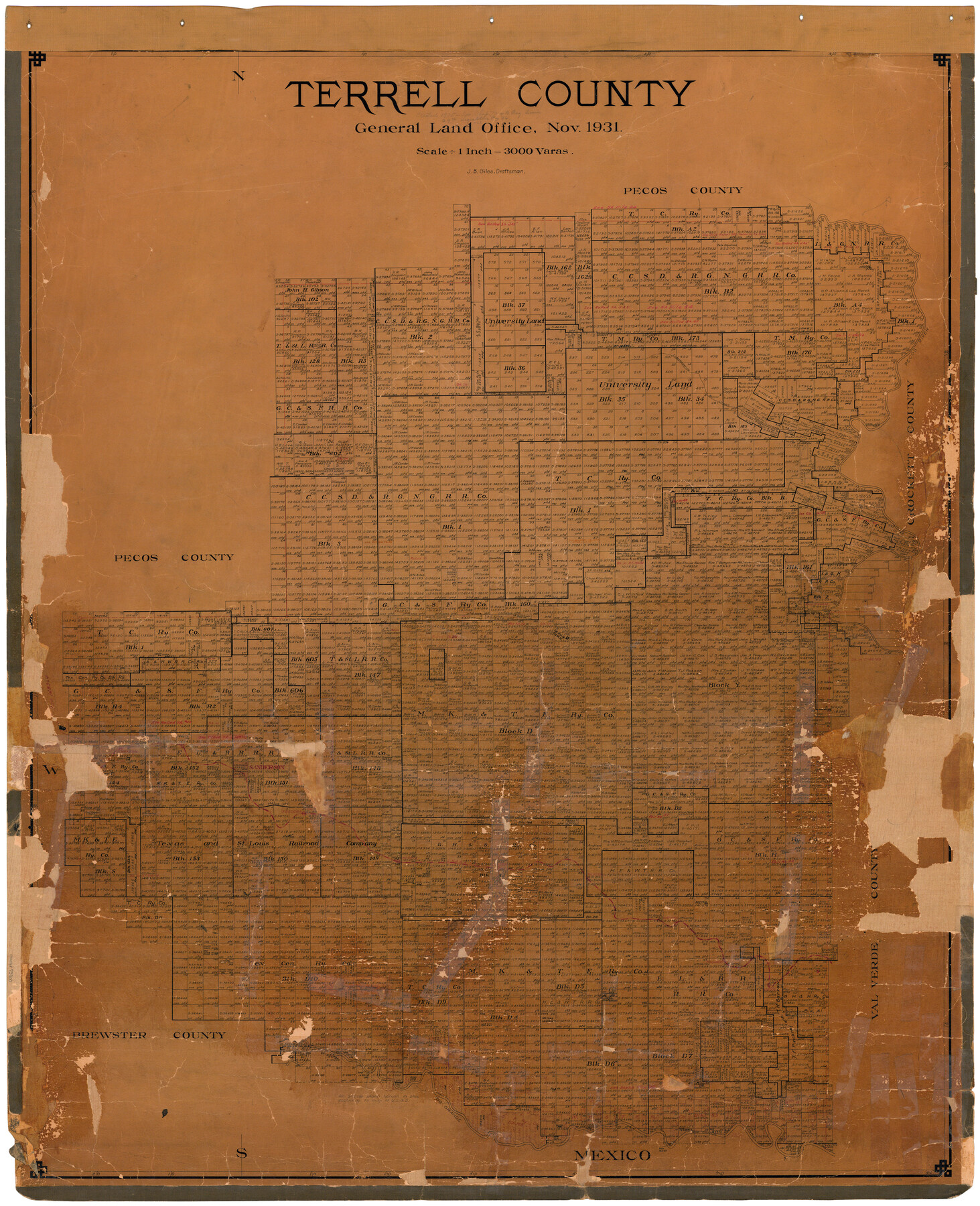
Terrell County
-
Map/Doc
73300
-
Collection
General Map Collection
-
Object Dates
1931 (Creation Date)
-
People and Organizations
Texas General Land Office (Publisher)
J.H. Walker (GLO Commissioner)
J. Bascom Giles (Draftsman)
-
Counties
Terrell
-
Subjects
County
-
Height x Width
48.5 x 40.5 inches
123.2 x 102.9 cm
-
Comments
Hand lettered.
Note on reverse side: "This map hung November 5, 1931 2 P.M. J. H. Walker, Commissioner by J. Bascom Giles." -
Features
GH&SA
Spring Creek
Lozier
Gawlan
Rio Grande
Cedar Arroyo
Cedar Spring
Malvado
Watkins
Mofeta
Independence Creek
Dryden
Thurston
Meyer's Spring
Feodora
Sanderson
Emerson
Geddes Spring
Richland Creek
Pecos River
Part of: General Map Collection
Nueces County Rolled Sketch 94

Print $108.00
Nueces County Rolled Sketch 94
1983
Size 24.2 x 36.6 inches
Map/Doc 7044
Flight Mission No. DAG-21K, Frame 99, Matagorda County

Print $20.00
- Digital $50.00
Flight Mission No. DAG-21K, Frame 99, Matagorda County
1952
Size 17.5 x 16.3 inches
Map/Doc 86428

Fisher County Sketch File 6

Print $6.00
- Digital $50.00
Fisher County Sketch File 6
Size 9.7 x 15.9 inches
Map/Doc 22563
Flight Mission No. BQR-4K, Frame 63, Brazoria County

Print $20.00
- Digital $50.00
Flight Mission No. BQR-4K, Frame 63, Brazoria County
1952
Size 18.9 x 22.5 inches
Map/Doc 83996
Morris County Boundary File 2

Print $6.00
- Digital $50.00
Morris County Boundary File 2
Size 14.1 x 8.7 inches
Map/Doc 57482
Terry County Working Sketch 1

Print $20.00
- Digital $50.00
Terry County Working Sketch 1
1938
Size 24.0 x 19.9 inches
Map/Doc 62106
Mills County Sketch File 9

Print $20.00
- Digital $50.00
Mills County Sketch File 9
Size 36.0 x 29.5 inches
Map/Doc 10544
Fannin County Sketch File 3

Print $4.00
- Digital $50.00
Fannin County Sketch File 3
Size 9.3 x 8.3 inches
Map/Doc 22447
Menard County Boundary File 3

Print $4.00
- Digital $50.00
Menard County Boundary File 3
Size 10.6 x 8.0 inches
Map/Doc 57072
Shelby County Sketch File 10

Print $4.00
- Digital $50.00
Shelby County Sketch File 10
Size 6.6 x 7.4 inches
Map/Doc 36611
Township 7 South Range 13 West, South Western District, Louisiana

Print $20.00
- Digital $50.00
Township 7 South Range 13 West, South Western District, Louisiana
1879
Size 19.7 x 24.7 inches
Map/Doc 65887
You may also like
United States - Gulf Coast - Galveston to Rio Grande

Print $20.00
- Digital $50.00
United States - Gulf Coast - Galveston to Rio Grande
1919
Size 26.7 x 18.3 inches
Map/Doc 72746
Part of Laguna Madre in Nueces and Kleberg Counties, showing Subdivision for Mineral Development

Print $20.00
- Digital $50.00
Part of Laguna Madre in Nueces and Kleberg Counties, showing Subdivision for Mineral Development
1948
Size 42.0 x 30.3 inches
Map/Doc 1921
Williamson County Sketch File 19

Print $24.00
- Digital $50.00
Williamson County Sketch File 19
Size 12.8 x 8.0 inches
Map/Doc 40345
Flight Mission No. BRE-2P, Frame 130, Nueces County

Print $20.00
- Digital $50.00
Flight Mission No. BRE-2P, Frame 130, Nueces County
1956
Size 18.6 x 22.3 inches
Map/Doc 86803
Jack County Working Sketch 15

Print $20.00
- Digital $50.00
Jack County Working Sketch 15
1982
Size 30.6 x 25.9 inches
Map/Doc 66441
Harris County Sketch File 90

Print $46.00
- Digital $50.00
Harris County Sketch File 90
1967
Size 12.2 x 14.4 inches
Map/Doc 25596
[Unknown Building Sketch]
![75793, [Unknown Building Sketch], Maddox Collection](https://historictexasmaps.com/wmedia_w700/maps/75793.tif.jpg)
Print $20.00
- Digital $50.00
[Unknown Building Sketch]
Size 15.3 x 23.0 inches
Map/Doc 75793
Flight Mission No. DAH-9M, Frame 198, Orange County

Print $20.00
- Digital $50.00
Flight Mission No. DAH-9M, Frame 198, Orange County
1953
Size 18.6 x 22.5 inches
Map/Doc 86866
Map of Texas with population and location of principal towns and cities according to latest reliable statistics

Print $20.00
- Digital $50.00
Map of Texas with population and location of principal towns and cities according to latest reliable statistics
1906
Size 18.6 x 20.5 inches
Map/Doc 95871
Lake Corpus Christi and a city map of Mathis, Texas [Verso]
![94171, Lake Corpus Christi and a city map of Mathis, Texas [Verso], General Map Collection](https://historictexasmaps.com/wmedia_w700/maps/94171.tif.jpg)
Lake Corpus Christi and a city map of Mathis, Texas [Verso]
1984
Size 29.3 x 22.9 inches
Map/Doc 94171
General Highway Map, Kimble County, Texas

Print $20.00
General Highway Map, Kimble County, Texas
1961
Size 24.6 x 18.2 inches
Map/Doc 79554
Aransas County Rolled Sketch 26

Print $20.00
- Digital $50.00
Aransas County Rolled Sketch 26
1984
Size 18.3 x 24.4 inches
Map/Doc 5060