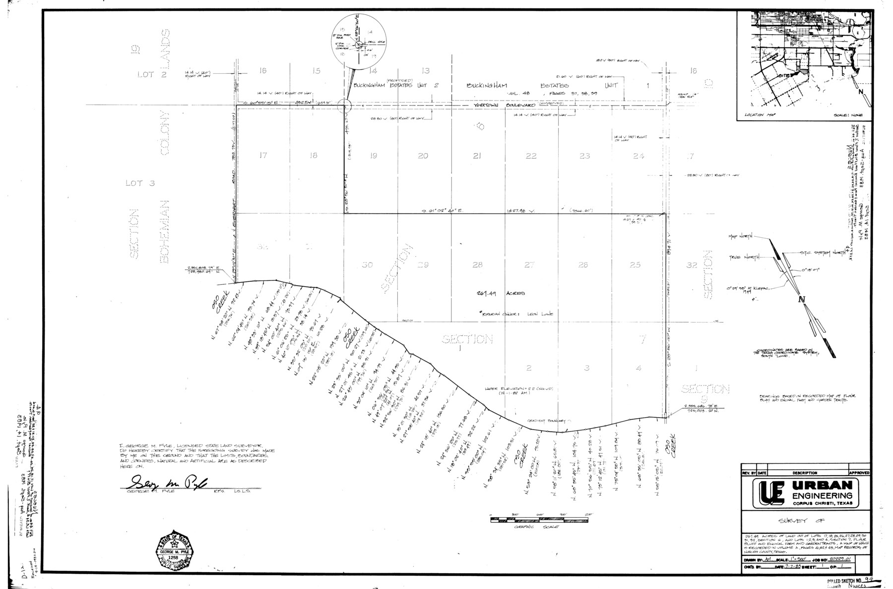
Nueces County Rolled Sketch 94
[Sketch, report, and exhibits regarding a shoreline survey of 267.49 acres of land out of Lots 17, 18, 25, 26, 27, 28, 29, 30, 31, and 32, Section 6 and Lots 1, 2, 3, and 4, Section 7, Flour Bluff and Encinal Farm and Garden Tracts]
-
Map/Doc
7044
-
Collection
General Map Collection
-
Object Dates
1983 (Creation Date)
-
People and Organizations
George M. Pyle (Surveyor/Engineer)
-
Counties
Nueces
-
Subjects
Surveying Rolled Sketch
-
Height x Width
24.2 x 36.6 inches
61.5 x 93.0 cm
Part of: General Map Collection
[Galveston, Harrisburg & San Antonio Railway]
![64402, [Galveston, Harrisburg & San Antonio Railway], General Map Collection](https://historictexasmaps.com/wmedia_w700/maps/64402.tif.jpg)
Print $20.00
- Digital $50.00
[Galveston, Harrisburg & San Antonio Railway]
1892
Size 13.5 x 33.7 inches
Map/Doc 64402
Real County Working Sketch 51

Print $20.00
- Digital $50.00
Real County Working Sketch 51
1957
Size 28.1 x 24.1 inches
Map/Doc 71943
Chambers County Aerial Photograph Index Sheet 2

Print $20.00
- Digital $50.00
Chambers County Aerial Photograph Index Sheet 2
1956
Size 19.4 x 15.7 inches
Map/Doc 83683

Reagan County Working Sketch 37

Print $20.00
- Digital $50.00
Reagan County Working Sketch 37
1966
Size 34.3 x 45.1 inches
Map/Doc 71879
San Luis Pass to East Matagorda Bay

Print $20.00
- Digital $50.00
San Luis Pass to East Matagorda Bay
1966
Size 34.6 x 46.5 inches
Map/Doc 69965

Menard County Boundary File 1

Print $14.00
- Digital $50.00
Menard County Boundary File 1
Size 12.7 x 8.1 inches
Map/Doc 57035
Flight Mission No. CRK-8P, Frame 122, Refugio County

Print $20.00
- Digital $50.00
Flight Mission No. CRK-8P, Frame 122, Refugio County
1956
Size 18.4 x 22.1 inches
Map/Doc 86977
Energy Map of Texas

Print $20.00
- Digital $50.00
Energy Map of Texas
2020
Size 36.0 x 36.0 inches
Map/Doc 96436
Rusk County Working Sketch Graphic Index

Print $20.00
- Digital $50.00
Rusk County Working Sketch Graphic Index
1932
Size 45.6 x 34.9 inches
Map/Doc 76688
Leon County Sketch File 25

Print $26.00
- Digital $50.00
Leon County Sketch File 25
Size 11.3 x 8.5 inches
Map/Doc 29788
You may also like
Newton County Rolled Sketch JFB

Print $20.00
- Digital $50.00
Newton County Rolled Sketch JFB
1936
Size 16.0 x 38.3 inches
Map/Doc 6858
Map of Childress, Childress County, Texas on the Line of the Fort Worth and Denver City Railway, Texas Pan-Handle Route

Print $20.00
- Digital $50.00
Map of Childress, Childress County, Texas on the Line of the Fort Worth and Denver City Railway, Texas Pan-Handle Route
1888
Size 35.6 x 28.0 inches
Map/Doc 7691
Uvalde County Working Sketch 16

Print $20.00
- Digital $50.00
Uvalde County Working Sketch 16
1946
Size 37.0 x 27.2 inches
Map/Doc 72086
Terrell County Working Sketch 74

Print $20.00
- Digital $50.00
Terrell County Working Sketch 74
1981
Size 37.5 x 24.6 inches
Map/Doc 69595
Ed. F. Mann's Subdivision of Stephens County School Land, Crosby County, Texas

Print $20.00
- Digital $50.00
Ed. F. Mann's Subdivision of Stephens County School Land, Crosby County, Texas
Size 19.2 x 22.3 inches
Map/Doc 90356
Uvalde County Working Sketch 2

Print $20.00
- Digital $50.00
Uvalde County Working Sketch 2
1911
Size 23.3 x 21.3 inches
Map/Doc 72072
Webb County Rolled Sketch 24

Print $20.00
- Digital $50.00
Webb County Rolled Sketch 24
1930
Size 33.0 x 23.0 inches
Map/Doc 8184
Map of Hill County

Print $40.00
- Digital $50.00
Map of Hill County
1884
Size 48.4 x 37.7 inches
Map/Doc 4979
[Wilson Strickland Survey]
![91374, [Wilson Strickland Survey], Twichell Survey Records](https://historictexasmaps.com/wmedia_w700/maps/91374-1.tif.jpg)
Print $20.00
- Digital $50.00
[Wilson Strickland Survey]
Size 38.1 x 31.5 inches
Map/Doc 91374
McLennan County Sketch File 21

Print $4.00
- Digital $50.00
McLennan County Sketch File 21
Size 9.0 x 8.2 inches
Map/Doc 31294
Free & Williams Subdivision of the north half of Outlots 56 and 57

Print $20.00
- Digital $50.00
Free & Williams Subdivision of the north half of Outlots 56 and 57
Size 10.9 x 29.5 inches
Map/Doc 475
Parker County Sketch File 34

Print $20.00
- Digital $50.00
Parker County Sketch File 34
1878
Size 21.3 x 13.6 inches
Map/Doc 12148