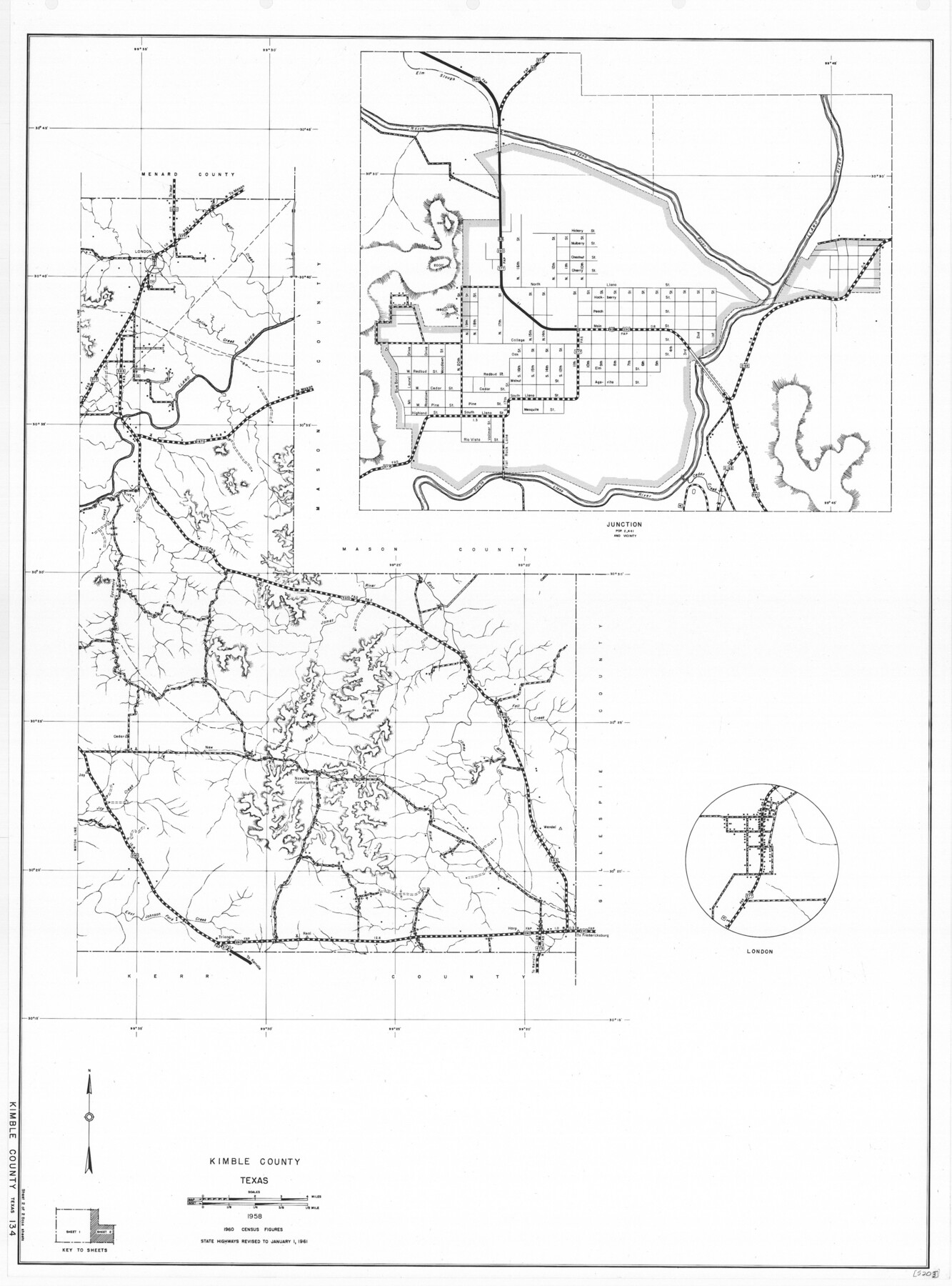
General Highway Map, Kimble County, Texas
-
Map/Doc
79554
-
Collection
Texas State Library and Archives
-
Object Dates
1961 (Creation Date)
-
People and Organizations
Texas State Highway Department (Publisher)
-
Counties
Kimble
-
Subjects
County
-
Height x Width
24.6 x 18.2 inches
62.5 x 46.2 cm
-
Comments
Prints available courtesy of the Texas State Library and Archives.
More info can be found here: TSLAC Map 05203
Part of: Texas State Library and Archives
Highway Map State of Texas

Print $20.00
Highway Map State of Texas
1919
Size 31.9 x 33.1 inches
Map/Doc 76291
General Highway Map, Baylor County, Texas

Print $20.00
General Highway Map, Baylor County, Texas
1961
Size 18.3 x 24.8 inches
Map/Doc 79363
General Highway Map, King County, Texas

Print $20.00
General Highway Map, King County, Texas
1940
Size 18.3 x 24.8 inches
Map/Doc 79161
Classification of Land Uses in Texas by Counties

Print $20.00
Classification of Land Uses in Texas by Counties
1935
Size 35.6 x 46.1 inches
Map/Doc 76310
General Highway Map. Detail of Cities and Towns in Waller County, Texas [Hempstead and vicinity]
![79701, General Highway Map. Detail of Cities and Towns in Waller County, Texas [Hempstead and vicinity], Texas State Library and Archives](https://historictexasmaps.com/wmedia_w700/maps/79701.tif.jpg)
Print $20.00
General Highway Map. Detail of Cities and Towns in Waller County, Texas [Hempstead and vicinity]
1961
Size 24.8 x 18.2 inches
Map/Doc 79701
A Map of Texas Showing the State Parks and the Municipal Parks

Print $20.00
A Map of Texas Showing the State Parks and the Municipal Parks
1936
Size 34.8 x 37.5 inches
Map/Doc 76311
Mapa de la Sierra Gorda y costa del Seno Mexicano desde la ciudad de Querétaro hasta la Bahía del Espíritu Santo, sus rios, ensenadas y provincias pacificadas por Don José de Escandón

Print $20.00
Mapa de la Sierra Gorda y costa del Seno Mexicano desde la ciudad de Querétaro hasta la Bahía del Espíritu Santo, sus rios, ensenadas y provincias pacificadas por Don José de Escandón
1792
Size 21.4 x 16.8 inches
Map/Doc 89047
General Highway Map, Falls County, Texas

Print $20.00
General Highway Map, Falls County, Texas
1961
Size 18.2 x 24.5 inches
Map/Doc 79462
General Highway Map, Lee County, Texas

Print $20.00
General Highway Map, Lee County, Texas
1961
Size 18.4 x 24.6 inches
Map/Doc 79567
The Texas and Oklahoma Official Railway and Hotel Guide Map

Print $20.00
The Texas and Oklahoma Official Railway and Hotel Guide Map
1906
Size 23.5 x 23.4 inches
Map/Doc 79316
General Highway Map, Borden County, Texas

Print $20.00
General Highway Map, Borden County, Texas
1940
Size 18.5 x 25.0 inches
Map/Doc 79021
General Highway Map. Detail of Cities and Towns in Tarrant County, Texas. City Map, Fort Worth and vicinity, Tarrant County, Texas

Print $20.00
General Highway Map. Detail of Cities and Towns in Tarrant County, Texas. City Map, Fort Worth and vicinity, Tarrant County, Texas
1961
Size 18.1 x 25.0 inches
Map/Doc 79665
You may also like
Schleicher County Sketch File 31

Print $4.00
- Digital $50.00
Schleicher County Sketch File 31
1940
Size 11.3 x 8.7 inches
Map/Doc 36530
[H. & T. C. RR. Company, Block 47]
![91153, [H. & T. C. RR. Company, Block 47], Twichell Survey Records](https://historictexasmaps.com/wmedia_w700/maps/91153-1.tif.jpg)
Print $20.00
- Digital $50.00
[H. & T. C. RR. Company, Block 47]
1888
Size 16.9 x 21.2 inches
Map/Doc 91153
Panola County Working Sketch 23

Print $20.00
- Digital $50.00
Panola County Working Sketch 23
1951
Map/Doc 71432
Jeff Davis County Sketch File 7

Print $30.00
- Digital $50.00
Jeff Davis County Sketch File 7
1879
Size 12.8 x 8.1 inches
Map/Doc 27905

Williamson County Sketch File 23

Print $4.00
- Digital $50.00
Williamson County Sketch File 23
1877
Size 12.8 x 8.1 inches
Map/Doc 40353
Harris County Working Sketch 4

Print $20.00
- Digital $50.00
Harris County Working Sketch 4
Size 20.7 x 26.6 inches
Map/Doc 65896
Texas Prospectors and Historians Map

Digital $50.00
Texas Prospectors and Historians Map
Size 22.4 x 29.2 inches
Map/Doc 94411
Concho County Sketch File 1

Print $5.00
- Digital $50.00
Concho County Sketch File 1
1856
Size 5.0 x 6.6 inches
Map/Doc 19121
Culberson County Rolled Sketch 66

Print $20.00
- Digital $50.00
Culberson County Rolled Sketch 66
1987
Size 24.4 x 19.7 inches
Map/Doc 5682
County Map of the Pan-Handle of Texas, and the line of the Denver, Texas and Ft. Worth R'y

Print $20.00
County Map of the Pan-Handle of Texas, and the line of the Denver, Texas and Ft. Worth R'y
1888
Size 7.5 x 10.9 inches
Map/Doc 76296
