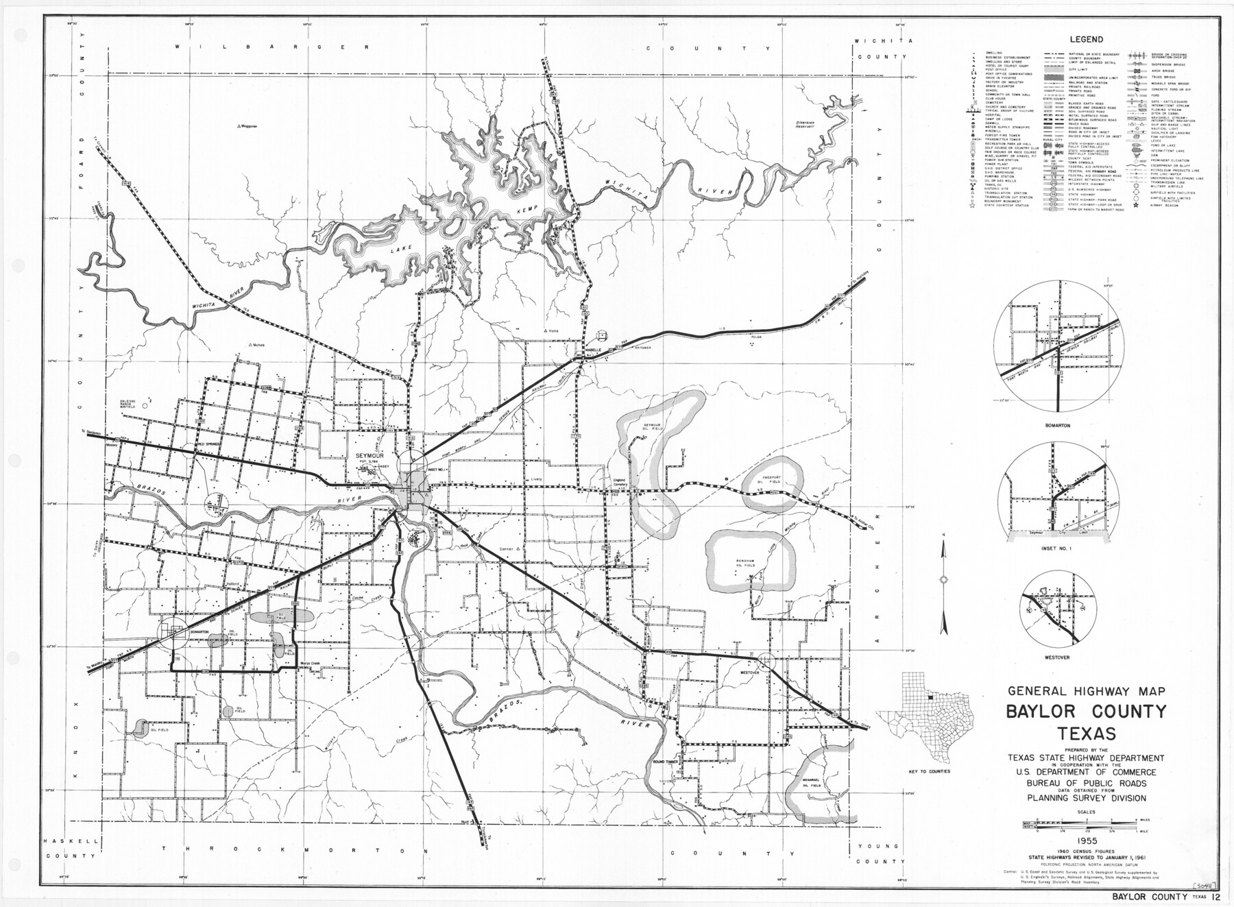
General Highway Map, Baylor County, Texas
- 
                          Map/Doc79363
- 
                            CollectionTexas State Library and Archives
- 
                            Object Dates1961 (Creation Date)
- 
                            People and OrganizationsTexas State Highway Department (Publisher)
- 
                            CountiesBaylor
- 
                            SubjectsCounty
- 
                            Height x Width18.3 x 24.8 inches46.5 x 63.0 cm
- 
                            CommentsPrints available courtesy of the Texas State Library and Archives.
 More info can be found here: TSLAC Map 05048
Part of: Texas State Library and Archives
            General Highway Map.  Detail of Cities and Towns in Kinney County, Uvalde County  [Uvalde and vicinity]
            
                                    ![79557, General Highway Map.  Detail of Cities and Towns in Kinney County, Uvalde County  [Uvalde and vicinity], Texas State Library and Archives](https://historictexasmaps.com/wmedia_w700/maps/79557.tif.jpg) 


    ![79557, General Highway Map.  Detail of Cities and Towns in Kinney County, Uvalde County  [Uvalde and vicinity], Texas State Library and Archives](https://historictexasmaps.com/wmedia_w700/maps/79557.tif.jpg) 
                                
            
                                            Print $20.00                    
                                    
                General Highway Map. Detail of Cities and Towns in Kinney County, Uvalde County [Uvalde and vicinity]
1961
Size 18.2 x 24.6 inches
                                Map/Doc 79557
            
            General Highway Map, Hunt County, Texas


                                            Print $20.00                    
                                    
                General Highway Map, Hunt County, Texas
1940
Size 25.0 x 18.5 inches
                                Map/Doc 79136
            
            Military Reconnaissance of the Arkansas, Rio Del Norte, and Rio Gila


                                            Print $40.00                    
                                    
                Military Reconnaissance of the Arkansas, Rio Del Norte, and Rio Gila
1847
Size 33.3 x 72.6 inches
                                Map/Doc 76240
            
            General Highway Map, Jones County, Texas


                                            Print $20.00                    
                                    
                General Highway Map, Jones County, Texas
1961
Size 18.2 x 24.5 inches
                                Map/Doc 79546
            
            General Highway Map.  Detail of Cities and Towns in Walker County, Texas  [Huntsville and vicinity]
            
                                    ![79699, General Highway Map.  Detail of Cities and Towns in Walker County, Texas  [Huntsville and vicinity], Texas State Library and Archives](https://historictexasmaps.com/wmedia_w700/maps/79699.tif.jpg) 


    ![79699, General Highway Map.  Detail of Cities and Towns in Walker County, Texas  [Huntsville and vicinity], Texas State Library and Archives](https://historictexasmaps.com/wmedia_w700/maps/79699.tif.jpg) 
                                
            
                                            Print $20.00                    
                                    
                General Highway Map. Detail of Cities and Towns in Walker County, Texas [Huntsville and vicinity]
1961
Size 18.1 x 24.8 inches
                                Map/Doc 79699
            
            General Highway Map, Anderson County, Texas


                                            Print $20.00                    
                                    
                General Highway Map, Anderson County, Texas
1961
Size 18.3 x 25.0 inches
                                Map/Doc 79346
            
            General Highway Map, Brown County, Texas


                                            Print $20.00                    
                                    
                General Highway Map, Brown County, Texas
1961
Size 24.8 x 18.2 inches
                                Map/Doc 79389
            
            General Highway Map, Cooke County, Texas


                                            Print $20.00                    
                                    
                General Highway Map, Cooke County, Texas
1961
Size 24.8 x 18.2 inches
                                Map/Doc 79421
            
            General Highway Map, Lampasas County, Texas


                                            Print $20.00                    
                                    
                General Highway Map, Lampasas County, Texas
1961
Size 18.2 x 24.7 inches
                                Map/Doc 79563
            
            General Highway Map.  Detail of Cities and Towns in Harris County, Texas.  City Map [of] Houston, Pasadena, West University Place, Bellaire, Galena Park, Jacinto City, South Houston, South Side Place, Deer Park, and vicinity, Harris County, Texas
            
                                    ![79507, General Highway Map.  Detail of Cities and Towns in Harris County, Texas.  City Map [of] Houston, Pasadena, West University Place, Bellaire, Galena Park, Jacinto City, South Houston, South Side Place, Deer Park, and vicinity, Harris County, Texas, Texas State Library and Archives](https://historictexasmaps.com/wmedia_w700/maps/79507.tif.jpg) 


    ![79507, General Highway Map.  Detail of Cities and Towns in Harris County, Texas.  City Map [of] Houston, Pasadena, West University Place, Bellaire, Galena Park, Jacinto City, South Houston, South Side Place, Deer Park, and vicinity, Harris County, Texas, Texas State Library and Archives](https://historictexasmaps.com/wmedia_w700/maps/79507.tif.jpg) 
                                
            
                                            Print $20.00                    
                                    
                General Highway Map. Detail of Cities and Towns in Harris County, Texas. City Map [of] Houston, Pasadena, West University Place, Bellaire, Galena Park, Jacinto City, South Houston, South Side Place, Deer Park, and vicinity, Harris County, Texas
1961
Size 18.1 x 24.7 inches
                                Map/Doc 79507
            
            General Highway Map, Sherman County, Texas


                                            Print $20.00                    
                                    
                General Highway Map, Sherman County, Texas
1961
Size 18.2 x 24.8 inches
                                Map/Doc 79653
            
            General Highway Map, Motley County, Texas


                                            Print $20.00                    
                                    
                General Highway Map, Motley County, Texas
1961
Size 24.7 x 18.1 inches
                                Map/Doc 79605
            You may also like
            Austin County Working Sketch 8


                                            Print $20.00                    
                                             -                         Digital $50.00                                    
                Austin County Working Sketch 8
1992
Size 28.7 x 31.6 inches
                                Map/Doc 67249
            
            Bowie County Working Sketch 22


                                            Print $40.00                    
                                             -                         Digital $50.00                                    
                Bowie County Working Sketch 22
1968
Size 49.0 x 37.8 inches
                                Map/Doc 67426
            
            Concho County Sketch File 31


                                            Print $30.00                    
                                             -                         Digital $50.00                                    
                Concho County Sketch File 31
1911
Size 11.2 x 9.0 inches
                                Map/Doc 19175
            
            Sutton County Boundary File 4


                                            Print $20.00                    
                                             -                         Digital $50.00                                    
                Sutton County Boundary File 4
Size 14.2 x 8.8 inches
                                Map/Doc 59035
            
            Reagan County Working Sketch 14a


                                            Print $20.00                    
                                             -                         Digital $50.00                                    
                Reagan County Working Sketch 14a
1949
Size 25.9 x 15.2 inches
                                Map/Doc 71854
            
            Flight Mission No. DAG-23K, Frame 150, Matagorda County


                                            Print $20.00                    
                                             -                         Digital $50.00                                    
                Flight Mission No. DAG-23K, Frame 150, Matagorda County
1953
Size 18.6 x 22.4 inches
                                Map/Doc 86498
            
            A New and Correct County Map of the State of Texas


                                            Print $20.00                    
                                             -                         Digital $50.00                                    
                A New and Correct County Map of the State of Texas
1891
Size 22.4 x 27.3 inches
                                Map/Doc 95760
            
            Map of Texas compiled from surveys recorded in the Land Office of Texas and other official surveys


                                            Print $20.00                    
                                             -                         Digital $50.00                                    
                Map of Texas compiled from surveys recorded in the Land Office of Texas and other official surveys
Size 24.6 x 24.2 inches
                                Map/Doc 96435
            
            Flight Mission No. DQO-8K, Frame 45, Galveston County


                                            Print $20.00                    
                                             -                         Digital $50.00                                    
                Flight Mission No. DQO-8K, Frame 45, Galveston County
1952
Size 18.8 x 22.3 inches
                                Map/Doc 85152
            
            Flight Mission No. DQN-1K, Frame 78, Calhoun County


                                            Print $20.00                    
                                             -                         Digital $50.00                                    
                Flight Mission No. DQN-1K, Frame 78, Calhoun County
1953
Size 18.5 x 22.1 inches
                                Map/Doc 84163
            
            Flight Mission No. CRC-1R, Frame 152, Chambers County


                                            Print $20.00                    
                                             -                         Digital $50.00                                    
                Flight Mission No. CRC-1R, Frame 152, Chambers County
1956
Size 18.8 x 22.5 inches
                                Map/Doc 84714
            
            Shackelford County Boundary File 79


                                            Print $26.00                    
                                             -                         Digital $50.00                                    
                Shackelford County Boundary File 79
Size 9.5 x 4.0 inches
                                Map/Doc 58737
            