Wilson County Rolled Sketch 4
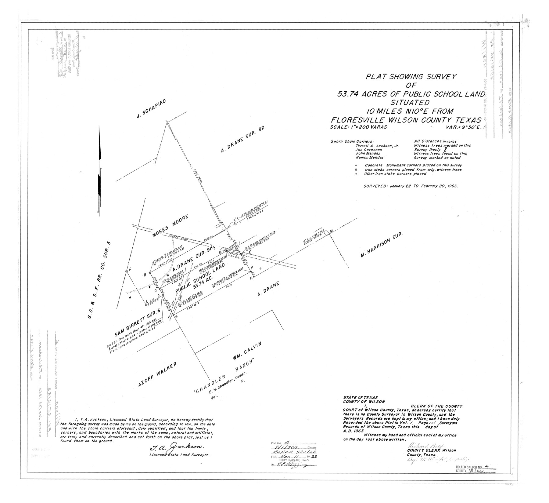
Plat showing survey of 53.74 acres of Public School Land situated north from Floresville, Wilson County, Texas
-
Map/Doc
8370
-
Collection
General Map Collection
-
Object Dates
1963 (Survey Date)
1963/3/11 (File Date)
-
People and Organizations
T.A. Jackson (Surveyor/Engineer)
-
Counties
Wilson
-
Subjects
Surveying Rolled Sketch
-
Height x Width
27.1 x 29.6 inches
68.8 x 75.2 cm
-
Scale
1" = 200 varas
Part of: General Map Collection
Flight Mission No. DAH-9M, Frame 86, Orange County

Print $20.00
- Digital $50.00
Flight Mission No. DAH-9M, Frame 86, Orange County
1953
Size 18.4 x 22.2 inches
Map/Doc 86850
Van Zandt County Working Sketch 3

Print $20.00
- Digital $50.00
Van Zandt County Working Sketch 3
1923
Size 20.1 x 16.4 inches
Map/Doc 72252
Zapata County Sketch File 13b

Print $6.00
- Digital $50.00
Zapata County Sketch File 13b
1936
Size 11.4 x 8.9 inches
Map/Doc 40954
Map of Wheeler County

Print $20.00
- Digital $50.00
Map of Wheeler County
1899
Size 40.1 x 32.7 inches
Map/Doc 63120
Taylor County Sketch File 17

Print $40.00
- Digital $50.00
Taylor County Sketch File 17
Size 14.5 x 17.7 inches
Map/Doc 37811
Flight Mission No. CUG-1P, Frame 161, Kleberg County

Print $20.00
- Digital $50.00
Flight Mission No. CUG-1P, Frame 161, Kleberg County
1956
Size 18.5 x 22.3 inches
Map/Doc 86168
Map showing the Distribution of Slaves in the Southern States

Print $20.00
- Digital $50.00
Map showing the Distribution of Slaves in the Southern States
1861
Size 15.2 x 18.3 inches
Map/Doc 96634
[Surveys in Austin's Colony on both sides of the Navidad River]
![217, [Surveys in Austin's Colony on both sides of the Navidad River], General Map Collection](https://historictexasmaps.com/wmedia_w700/maps/217.tif.jpg)
Print $20.00
- Digital $50.00
[Surveys in Austin's Colony on both sides of the Navidad River]
1831
Size 18.8 x 12.7 inches
Map/Doc 217
Flight Mission No. DAG-21K, Frame 38, Matagorda County

Print $20.00
- Digital $50.00
Flight Mission No. DAG-21K, Frame 38, Matagorda County
1952
Size 18.6 x 22.3 inches
Map/Doc 86405
Harris County Sketch File 30

Print $21.00
- Digital $50.00
Harris County Sketch File 30
Size 11.3 x 8.5 inches
Map/Doc 25416
Flight Mission No. DQO-8K, Frame 53, Galveston County

Print $20.00
- Digital $50.00
Flight Mission No. DQO-8K, Frame 53, Galveston County
1952
Size 18.6 x 22.3 inches
Map/Doc 85160
Marion County Working Sketch 11

Print $20.00
- Digital $50.00
Marion County Working Sketch 11
1952
Size 23.8 x 28.7 inches
Map/Doc 70786
You may also like
Frio County Working Sketch 11

Print $20.00
- Digital $50.00
Frio County Working Sketch 11
1952
Size 22.9 x 20.0 inches
Map/Doc 69285
Louisiana and Texas Intracoastal Waterway, Section 7, Galveston Bay to Brazos River and Section 8, Brazos River to Matagorda Bay

Print $20.00
- Digital $50.00
Louisiana and Texas Intracoastal Waterway, Section 7, Galveston Bay to Brazos River and Section 8, Brazos River to Matagorda Bay
1937
Size 30.7 x 42.7 inches
Map/Doc 73064
Williamson County Sketch File 19

Print $24.00
- Digital $50.00
Williamson County Sketch File 19
Size 12.8 x 8.0 inches
Map/Doc 40345
Burleson County Working Sketch 17

Print $20.00
- Digital $50.00
Burleson County Working Sketch 17
1980
Size 20.5 x 37.6 inches
Map/Doc 67736
Hydrographic Survey H-1288B Corpus Christi Pass

Print $40.00
- Digital $50.00
Hydrographic Survey H-1288B Corpus Christi Pass
1875
Size 31.0 x 52.6 inches
Map/Doc 2691
Jefferson County Working Sketch 11

Print $20.00
- Digital $50.00
Jefferson County Working Sketch 11
1943
Size 46.6 x 43.0 inches
Map/Doc 66554
Van Zandt County Sketch File 39

Print $6.00
- Digital $50.00
Van Zandt County Sketch File 39
1871
Size 10.8 x 13.4 inches
Map/Doc 39484
Val Verde County Sketch File Z4

Print $8.00
- Digital $50.00
Val Verde County Sketch File Z4
1885
Size 14.3 x 8.9 inches
Map/Doc 39134
Trinity River, White Rock Creek Sheet

Print $6.00
- Digital $50.00
Trinity River, White Rock Creek Sheet
1923
Size 33.0 x 24.2 inches
Map/Doc 65198
Polk County Rolled Sketch 26

Print $20.00
- Digital $50.00
Polk County Rolled Sketch 26
Size 26.3 x 38.0 inches
Map/Doc 7314
Flight Mission No. CRC-4R, Frame 102, Chambers County

Print $20.00
- Digital $50.00
Flight Mission No. CRC-4R, Frame 102, Chambers County
1956
Size 18.5 x 22.4 inches
Map/Doc 84899
