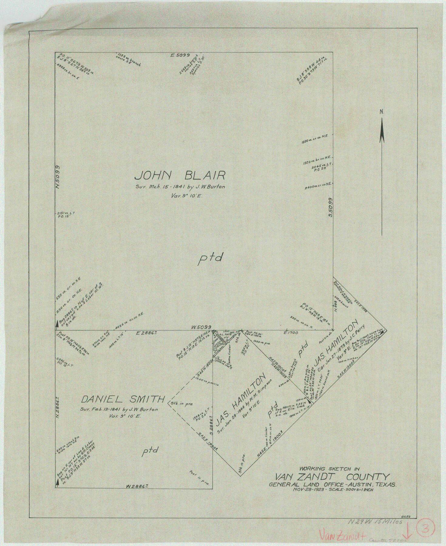
Van Zandt County Working Sketch 3
-
Map/Doc
72252
-
Collection
General Map Collection
-
Object Dates
11/28/1923 (Creation Date)
-
People and Organizations
J. Bascom Giles (Draftsman)
-
Counties
Van Zandt
-
Subjects
Surveying Working Sketch
-
Height x Width
20.1 x 16.4 inches
51.1 x 41.7 cm
-
Scale
1" = 500 varas
Part of: General Map Collection
Chambers County Rolled Sketch 7

Print $20.00
- Digital $50.00
Chambers County Rolled Sketch 7
Size 39.8 x 23.1 inches
Map/Doc 8611
Dickens County Sketch File 16

Print $4.00
- Digital $50.00
Dickens County Sketch File 16
Size 7.4 x 11.1 inches
Map/Doc 20975
Kaufman County Boundary File 6

Print $14.00
- Digital $50.00
Kaufman County Boundary File 6
Size 11.2 x 8.7 inches
Map/Doc 55956
Erath County Working Sketch 11

Print $20.00
- Digital $50.00
Erath County Working Sketch 11
1951
Size 45.1 x 36.2 inches
Map/Doc 69092
Terrell County

Print $20.00
- Digital $50.00
Terrell County
1905
Size 40.5 x 32.3 inches
Map/Doc 4075
Kinney County Working Sketch 50

Print $20.00
- Digital $50.00
Kinney County Working Sketch 50
1980
Size 19.4 x 26.9 inches
Map/Doc 70232
Tom Green County Rolled Sketch 23

Print $20.00
- Digital $50.00
Tom Green County Rolled Sketch 23
Size 19.1 x 21.9 inches
Map/Doc 8005
Floyd County Rolled Sketch 11

Print $20.00
- Digital $50.00
Floyd County Rolled Sketch 11
2000
Size 15.5 x 20.9 inches
Map/Doc 5884
Brewster County Sketch File NS-15

Print $40.00
- Digital $50.00
Brewster County Sketch File NS-15
1977
Size 16.7 x 14.4 inches
Map/Doc 16298
Dawson County Boundary File 3 (2)

Print $40.00
- Digital $50.00
Dawson County Boundary File 3 (2)
Size 13.2 x 33.5 inches
Map/Doc 52367
Aransas County Rolled Sketch 16

Print $40.00
- Digital $50.00
Aransas County Rolled Sketch 16
1965
Size 49.9 x 97.2 inches
Map/Doc 9004
Flight Mission No. CRC-2R, Frame 192, Chambers County

Print $20.00
- Digital $50.00
Flight Mission No. CRC-2R, Frame 192, Chambers County
1956
Size 18.6 x 22.3 inches
Map/Doc 84770
You may also like
Hudspeth County Sketch File 7

Print $6.00
- Digital $50.00
Hudspeth County Sketch File 7
1900
Size 14.2 x 8.7 inches
Map/Doc 26892
[G. B. & C. Blocks K3 and K4]
![90512, [G. B. & C. Blocks K3 and K4], Twichell Survey Records](https://historictexasmaps.com/wmedia_w700/maps/90512-1.tif.jpg)
Print $20.00
- Digital $50.00
[G. B. & C. Blocks K3 and K4]
Size 14.0 x 14.5 inches
Map/Doc 90512
Fort Bend County State Real Property Sketch 12

Print $40.00
- Digital $50.00
Fort Bend County State Real Property Sketch 12
1986
Size 43.2 x 35.0 inches
Map/Doc 61686
Haskell County Sketch File A

Print $4.00
- Digital $50.00
Haskell County Sketch File A
Size 7.8 x 11.9 inches
Map/Doc 26117
Galveston County NRC Article 33.136 Sketch 84

Print $62.00
- Digital $50.00
Galveston County NRC Article 33.136 Sketch 84
2017
Size 17.2 x 22.0 inches
Map/Doc 94854
Mitchell County Working Sketch 4

Print $20.00
- Digital $50.00
Mitchell County Working Sketch 4
1926
Size 28.5 x 31.5 inches
Map/Doc 71061
[County School Land for Shackelford, Reeves, Hardeman, Val Verde, Hood, Martin, Rusk, Atascosa, and Edwards Counties]
![91114, [County School Land for Shackelford, Reeves, Hardeman, Val Verde, Hood, Martin, Rusk, Atascosa, and Edwards Counties], Twichell Survey Records](https://historictexasmaps.com/wmedia_w700/maps/91114-1.tif.jpg)
Print $2.00
- Digital $50.00
[County School Land for Shackelford, Reeves, Hardeman, Val Verde, Hood, Martin, Rusk, Atascosa, and Edwards Counties]
Size 8.2 x 5.9 inches
Map/Doc 91114
San Patricio County Sketch File 3

Print $10.00
- Digital $50.00
San Patricio County Sketch File 3
1850
Size 11.0 x 15.6 inches
Map/Doc 36029
Wichita County Rolled Sketch 9A

Print $20.00
- Digital $50.00
Wichita County Rolled Sketch 9A
1917
Size 32.4 x 27.9 inches
Map/Doc 8247
Hardeman County Working Sketch 10

Print $20.00
- Digital $50.00
Hardeman County Working Sketch 10
1960
Size 21.9 x 29.9 inches
Map/Doc 63391
[Map of Henderson County]
![76767, [Map of Henderson County], General Map Collection](https://historictexasmaps.com/wmedia_w700/maps/76767.tif.jpg)
Print $20.00
- Digital $50.00
[Map of Henderson County]
1854
Size 29.7 x 22.0 inches
Map/Doc 76767
Cottle County Sketch File 13

Print $20.00
- Digital $50.00
Cottle County Sketch File 13
1904
Size 15.8 x 15.8 inches
Map/Doc 11195