Hudspeth County Sketch File 7
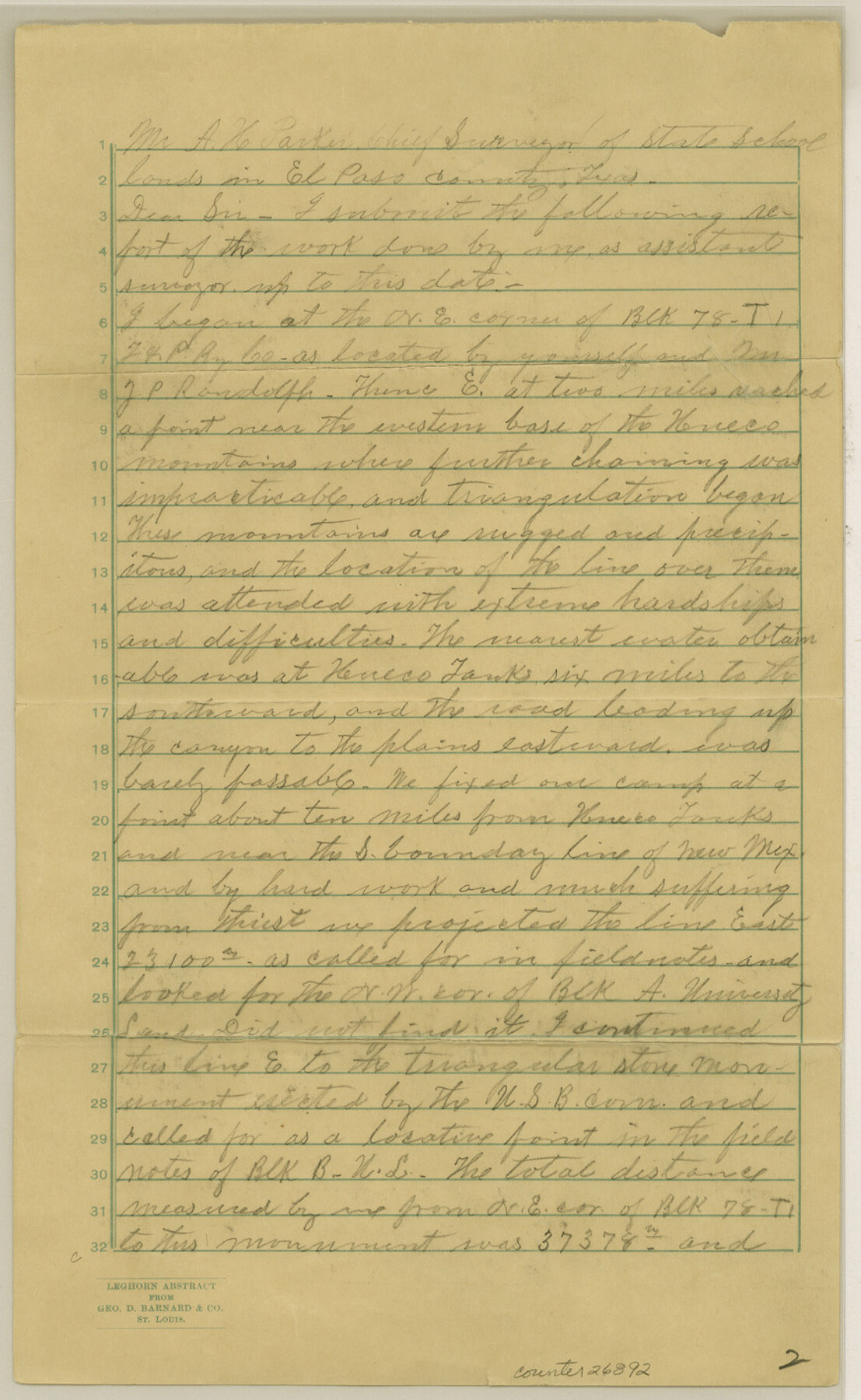
[A. S. Howren's report to A. H. Parker]
-
Map/Doc
26892
-
Collection
General Map Collection
-
Object Dates
6/27/1900 (Creation Date)
-
People and Organizations
A.S. Howren (Surveyor/Engineer)
A.H. Parker (Surveyor/Engineer)
J.P. Randolph (Surveyor/Engineer)
-
Counties
Hudspeth El Paso
-
Subjects
Surveying Sketch File
-
Height x Width
14.2 x 8.7 inches
36.1 x 22.1 cm
-
Medium
paper, manuscript
-
Features
Nueces Mountains
Hueco Tanks
Related maps
PSL Field Notes for Blocks 1, 5, 6, and 7 in El Paso County and Blocks 2, 3, 4, 8, 9, 10, 11, 12, 13, and 14 in Hudspeth County

PSL Field Notes for Blocks 1, 5, 6, and 7 in El Paso County and Blocks 2, 3, 4, 8, 9, 10, 11, 12, 13, and 14 in Hudspeth County
Map/Doc 81653
PSL Field Notes for Blocks 15 through 29 in Hudspeth County

PSL Field Notes for Blocks 15 through 29 in Hudspeth County
Map/Doc 81659
PSF Field Notes for Blocks 42 1/2 and 43 in Culberson and Hudspeth Counties, and Blocks 30 through 41 in Hudspeth County

PSF Field Notes for Blocks 42 1/2 and 43 in Culberson and Hudspeth Counties, and Blocks 30 through 41 in Hudspeth County
Map/Doc 81660
PSL Field Notes for Block 54 1/2 in Culberson and Hudspeth Counties, and Blocks 44, 45 1/2, 46, 47 1/2, 48, 49, 50, 51, 52 1/2, 53 1/2, 55 1/2, 56, and 57 in Hudspeth County

PSL Field Notes for Block 54 1/2 in Culberson and Hudspeth Counties, and Blocks 44, 45 1/2, 46, 47 1/2, 48, 49, 50, 51, 52 1/2, 53 1/2, 55 1/2, 56, and 57 in Hudspeth County
Map/Doc 81661
PSL Field Notes for Blocks 58, 59, 60 1/2, 61 1/2, 62 1/2, 63 1/2, 64 1/2, 65 1/2, 66 1/2, 67 1/2, 68 1/2, 69 1/2, 70, 71, and 72 in Hudspeth County

PSL Field Notes for Blocks 58, 59, 60 1/2, 61 1/2, 62 1/2, 63 1/2, 64 1/2, 65 1/2, 66 1/2, 67 1/2, 68 1/2, 69 1/2, 70, 71, and 72 in Hudspeth County
Map/Doc 81662
PSL Field Notes for Blocks 77 through 86 in Culberson County and Blocks 73 through 76 in Hudspeth County

PSL Field Notes for Blocks 77 through 86 in Culberson County and Blocks 73 through 76 in Hudspeth County
Map/Doc 81663
PSL Field Notes for Blocks 87 through 98 in Culberson County

PSL Field Notes for Blocks 87 through 98 in Culberson County
Map/Doc 81664
PSL Field Notes for Blocks 99, 100, 101, 103, 104, 105, 106, 107, 108, and 109 in Culberson County

PSL Field Notes for Blocks 99, 100, 101, 103, 104, 105, 106, 107, 108, and 109 in Culberson County
Map/Doc 81665
PSL Field Notes for Blocks 110 through 122 in Culberson County and Block 123 in Hudspeth County

PSL Field Notes for Blocks 110 through 122 in Culberson County and Block 123 in Hudspeth County
Map/Doc 81666
Part of: General Map Collection
Map of San Patricio County

Print $40.00
- Digital $50.00
Map of San Patricio County
1896
Size 31.6 x 51.2 inches
Map/Doc 63018
Lipscomb County Working Sketch 3

Print $20.00
- Digital $50.00
Lipscomb County Working Sketch 3
1965
Size 27.8 x 46.1 inches
Map/Doc 70579
Hardeman County Working Sketch 13

Print $20.00
- Digital $50.00
Hardeman County Working Sketch 13
1966
Size 35.8 x 45.7 inches
Map/Doc 63394
Reeves County Rolled Sketch 8

Print $40.00
- Digital $50.00
Reeves County Rolled Sketch 8
Size 22.6 x 64.6 inches
Map/Doc 9848
Austin County Sketch File 6b

Print $50.00
- Digital $50.00
Austin County Sketch File 6b
1894
Size 11.3 x 8.6 inches
Map/Doc 13872
Brewster County Sketch File S-36

Print $80.00
- Digital $50.00
Brewster County Sketch File S-36
1986
Size 14.4 x 8.8 inches
Map/Doc 15865
Webb County Rolled Sketch 60

Print $20.00
- Digital $50.00
Webb County Rolled Sketch 60
1947
Size 30.0 x 33.8 inches
Map/Doc 8211
Flight Mission No. DIX-3P, Frame 164, Aransas County

Print $20.00
- Digital $50.00
Flight Mission No. DIX-3P, Frame 164, Aransas County
1956
Size 17.8 x 18.0 inches
Map/Doc 83770
Wharton County Rolled Sketch 11

Print $20.00
- Digital $50.00
Wharton County Rolled Sketch 11
Size 27.7 x 37.1 inches
Map/Doc 8236
Stephens County Sketch File 7

Print $4.00
- Digital $50.00
Stephens County Sketch File 7
1875
Size 8.1 x 9.9 inches
Map/Doc 37025
Atascosa County Working Sketch 1a

Print $20.00
- Digital $50.00
Atascosa County Working Sketch 1a
1908
Size 35.8 x 40.2 inches
Map/Doc 67194
[Gulf, Colorado & Santa Fe Railway Company]
![64411, [Gulf, Colorado & Santa Fe Railway Company], General Map Collection](https://historictexasmaps.com/wmedia_w700/maps/64411.tif.jpg)
Print $20.00
- Digital $50.00
[Gulf, Colorado & Santa Fe Railway Company]
1893
Size 20.1 x 41.5 inches
Map/Doc 64411
You may also like
Rusk County Sketch File 26

Print $20.00
Rusk County Sketch File 26
1932
Size 38.1 x 22.6 inches
Map/Doc 10595
[Blk. M, T. & P. Blocks 33-36, Townships 5N and 6N]
![90548, [Blk. M, T. & P. Blocks 33-36, Townships 5N and 6N], Twichell Survey Records](https://historictexasmaps.com/wmedia_w700/maps/90548-1.tif.jpg)
Print $20.00
- Digital $50.00
[Blk. M, T. & P. Blocks 33-36, Townships 5N and 6N]
Size 12.3 x 16.1 inches
Map/Doc 90548
[Palmer and Castro Counties]
![1763, [Palmer and Castro Counties], General Map Collection](https://historictexasmaps.com/wmedia_w700/maps/1763-1.tif.jpg)
Print $20.00
- Digital $50.00
[Palmer and Castro Counties]
1910
Size 19.3 x 26.3 inches
Map/Doc 1763
Crockett County Working Sketch 35

Print $20.00
- Digital $50.00
Crockett County Working Sketch 35
1927
Size 20.2 x 25.5 inches
Map/Doc 68368
Flight Mission No. DCL-4C, Frame 122, Kenedy County

Print $20.00
- Digital $50.00
Flight Mission No. DCL-4C, Frame 122, Kenedy County
1943
Size 18.6 x 22.3 inches
Map/Doc 85821
Freestone County

Print $40.00
- Digital $50.00
Freestone County
1918
Size 49.0 x 41.0 inches
Map/Doc 4951

Kendall County Boundary File 2a

Print $12.00
- Digital $50.00
Kendall County Boundary File 2a
Size 10.0 x 7.9 inches
Map/Doc 55748

Cherokee County Sketch File 1

Print $6.00
- Digital $50.00
Cherokee County Sketch File 1
1857
Size 10.6 x 8.0 inches
Map/Doc 18109
Austin County Rolled Sketch 7

Print $47.00
- Digital $50.00
Austin County Rolled Sketch 7
1974
Size 10.4 x 15.3 inches
Map/Doc 42340
Current Miscellaneous File 107

Print $4.00
- Digital $50.00
Current Miscellaneous File 107
1994
Size 9.2 x 12.4 inches
Map/Doc 74707