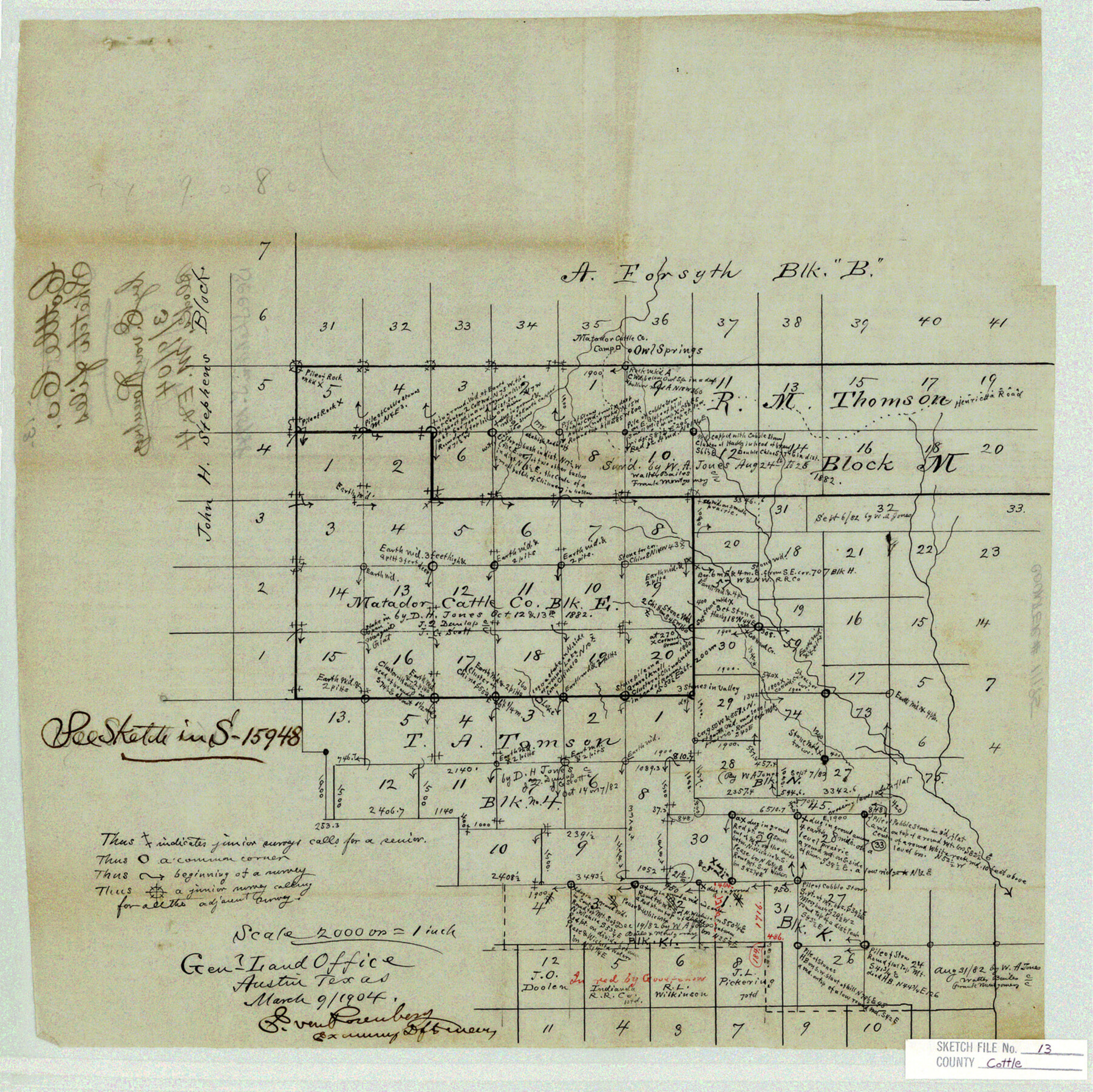
Cottle County Sketch File 13
[Office sketch of Matador Cattle Co. Block E and surrounding area north and east from Paducah]
-
Map/Doc
11195
-
Collection
General Map Collection
-
Object Dates
3/9/1904 (Creation Date)
-
People and Organizations
E. von Rosenberg (Draftsman)
-
Counties
Cottle
-
Subjects
Surveying Sketch File
-
Height x Width
15.8 x 15.8 inches
40.1 x 40.1 cm
-
Medium
paper, manuscript
-
Scale
1" = 2000 varas
-
Features
Owl Springs
Matador Cattle Co. Camp
Henrietta Road
Cottonwood Creek
Part of: General Map Collection
Brewster County Working Sketch 61

Print $20.00
- Digital $50.00
Brewster County Working Sketch 61
1955
Size 32.1 x 43.3 inches
Map/Doc 67662
Flight Mission No. DQN-1K, Frame 155, Calhoun County

Print $20.00
- Digital $50.00
Flight Mission No. DQN-1K, Frame 155, Calhoun County
1953
Size 18.5 x 22.2 inches
Map/Doc 84214
Young County Sketch File 8a

Print $4.00
- Digital $50.00
Young County Sketch File 8a
1858
Size 9.8 x 8.0 inches
Map/Doc 40862
Map of Hill County

Print $20.00
- Digital $50.00
Map of Hill County
1862
Size 22.1 x 24.7 inches
Map/Doc 3671
1882 Map of the Texas & Pacific R-Y Reserve

Print $20.00
- Digital $50.00
1882 Map of the Texas & Pacific R-Y Reserve
1887
Size 44.5 x 31.7 inches
Map/Doc 83559
Goliad County Working Sketch 10

Print $20.00
- Digital $50.00
Goliad County Working Sketch 10
1939
Size 39.9 x 42.4 inches
Map/Doc 63200
Jackson County Rolled Sketch 11

Print $20.00
- Digital $50.00
Jackson County Rolled Sketch 11
1941
Size 45.9 x 34.3 inches
Map/Doc 9260
Blanco County Working Sketch 12

Print $3.00
- Digital $50.00
Blanco County Working Sketch 12
1943
Size 11.9 x 10.9 inches
Map/Doc 67372
Stephens County Working Sketch 6

Print $20.00
- Digital $50.00
Stephens County Working Sketch 6
1919
Size 13.1 x 22.0 inches
Map/Doc 63949

Jack County Working Sketch 23

Print $20.00
- Digital $50.00
Jack County Working Sketch 23
2006
Size 18.4 x 22.0 inches
Map/Doc 83606
Flight Mission No. DAG-18K, Frame 73, Matagorda County

Print $20.00
- Digital $50.00
Flight Mission No. DAG-18K, Frame 73, Matagorda County
1952
Size 18.5 x 22.2 inches
Map/Doc 86366
You may also like
Webb County Sketch File EF

Print $38.00
- Digital $50.00
Webb County Sketch File EF
1932
Size 9.2 x 8.5 inches
Map/Doc 39681
Sutton County Working Sketch Graphic Index, Sheet 2 (Sketches 25 to Most Recent)

Print $40.00
- Digital $50.00
Sutton County Working Sketch Graphic Index, Sheet 2 (Sketches 25 to Most Recent)
1941
Size 41.2 x 55.2 inches
Map/Doc 76706
Bailey County

Print $40.00
- Digital $50.00
Bailey County
1956
Size 49.4 x 31.4 inches
Map/Doc 95423
Flight Mission No. CLL-1N, Frame 191, Willacy County

Print $20.00
- Digital $50.00
Flight Mission No. CLL-1N, Frame 191, Willacy County
1954
Size 18.3 x 22.0 inches
Map/Doc 87061
Kimble County Working Sketch 34

Print $20.00
- Digital $50.00
Kimble County Working Sketch 34
1945
Size 34.4 x 26.7 inches
Map/Doc 70102
Trails made and routes used by the Fourth U.S. Cavalry under command of General R.S. Mackenzie in its operations against hostile indians in Texas, Indian-Territory (now Oklahoma), New Mexico and Old Mexico during the period of 1871-2-3-4 and 5

Print $20.00
- Digital $50.00
Trails made and routes used by the Fourth U.S. Cavalry under command of General R.S. Mackenzie in its operations against hostile indians in Texas, Indian-Territory (now Oklahoma), New Mexico and Old Mexico during the period of 1871-2-3-4 and 5
1927
Size 37.0 x 34.2 inches
Map/Doc 62973
General Highway Map, Maverick County, Texas

Print $20.00
General Highway Map, Maverick County, Texas
1961
Size 18.2 x 24.6 inches
Map/Doc 79587
Flight Mission No. CRC-2R, Frame 121, Chambers County

Print $20.00
- Digital $50.00
Flight Mission No. CRC-2R, Frame 121, Chambers County
1956
Size 18.7 x 22.4 inches
Map/Doc 84745
Houston County

Print $20.00
- Digital $50.00
Houston County
1877
Size 25.9 x 26.2 inches
Map/Doc 3684
[Map of Terrell County]
![4074, [Map of Terrell County], General Map Collection](https://historictexasmaps.com/wmedia_w700/maps/4074.tif.jpg)
Print $20.00
- Digital $50.00
[Map of Terrell County]
Size 38.0 x 24.0 inches
Map/Doc 4074
Lamb County Sketch File C

Print $18.00
- Digital $50.00
Lamb County Sketch File C
1904
Size 10.2 x 8.4 inches
Map/Doc 29347
Crane County Rolled Sketch 5A

Print $20.00
- Digital $50.00
Crane County Rolled Sketch 5A
1927
Size 38.0 x 46.4 inches
Map/Doc 8678