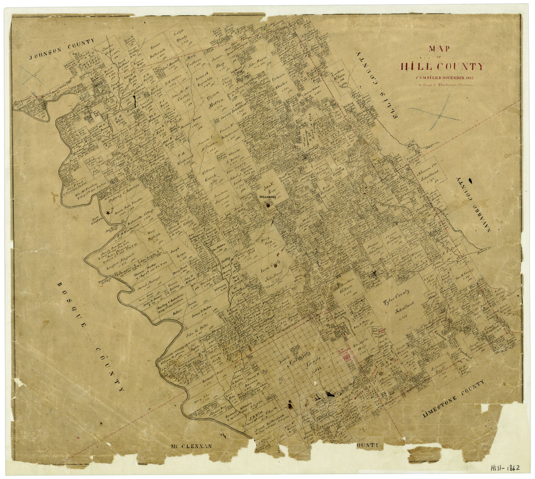
Map of Hill County
-
Map/Doc
3671
-
Collection
General Map Collection
-
Object Dates
11/1862 (Creation Date)
-
People and Organizations
George J. Thielepape (Compiler)
-
Counties
Hill
-
Subjects
County
-
Height x Width
22.1 x 24.7 inches
56.1 x 62.7 cm
-
Features
North Fork of Richland Creek
Wolf Creek
Bold Springs
Cottonwood Creek
Pin Oak Creek
Post Oak Creek
East Fork of Tahuacano Creek
Elingtons Creek
Towash Village
South Fork of Richland Creek
Aquilla Creek
Cobb Creek
Ash Creek
Rock Creek
Richland Creek
Caney's Creek
East Fork of Noland's Creek
Brumfield Creek
Hackberry Creek
Hillsboro
Bear Creek
Cedar Creek
Jose Maria Village
Camp Creek
Fort Graham
Battle Creek
Mill Creek
Uguila Creek
Noland's Creek
Part of: General Map Collection
Flight Mission No. DIX-3P, Frame 173, Aransas County

Print $20.00
- Digital $50.00
Flight Mission No. DIX-3P, Frame 173, Aransas County
1956
Size 17.8 x 17.9 inches
Map/Doc 83779
[Sketch for Mineral Application 19560 - 19588 - San Bernard River]
![65579, [Sketch for Mineral Application 19560 - 19588 - San Bernard River], General Map Collection](https://historictexasmaps.com/wmedia_w700/maps/65579.tif.jpg)
Print $40.00
- Digital $50.00
[Sketch for Mineral Application 19560 - 19588 - San Bernard River]
1928
Size 33.0 x 98.6 inches
Map/Doc 65579
Lynn County Boundary File 10

Print $110.00
- Digital $50.00
Lynn County Boundary File 10
Size 14.3 x 8.7 inches
Map/Doc 56709
Flight Mission No. DIX-8P, Frame 89, Aransas County

Print $20.00
- Digital $50.00
Flight Mission No. DIX-8P, Frame 89, Aransas County
1956
Size 18.7 x 22.4 inches
Map/Doc 83914
Trinity County Working Sketch 25

Print $20.00
- Digital $50.00
Trinity County Working Sketch 25
2010
Size 39.7 x 28.7 inches
Map/Doc 89600
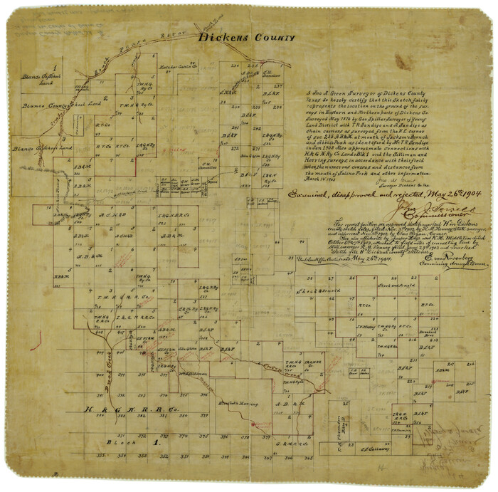
Dickens County Rolled Sketch 1/2
Print $20.00
- Digital $50.00
Dickens County Rolled Sketch 1/2
1903
Size 23.3 x 22.6 inches
Map/Doc 5705
Culberson County Rolled Sketch 45

Print $20.00
- Digital $50.00
Culberson County Rolled Sketch 45
1954
Size 19.1 x 23.4 inches
Map/Doc 5667
Fractional Township No. 7 South Range No. 4 East of the Indian Meridian, Indian Territory

Print $20.00
- Digital $50.00
Fractional Township No. 7 South Range No. 4 East of the Indian Meridian, Indian Territory
1898
Size 19.3 x 24.4 inches
Map/Doc 75207
[Cameron County]
![3365, [Cameron County], General Map Collection](https://historictexasmaps.com/wmedia_w700/maps/3365-2.tif.jpg)
Print $20.00
- Digital $50.00
[Cameron County]
Size 19.2 x 21.8 inches
Map/Doc 3365
Hemphill County Working Sketch 3

Print $40.00
- Digital $50.00
Hemphill County Working Sketch 3
1940
Size 51.8 x 27.4 inches
Map/Doc 66098
Hood County Rolled Sketch 3

Print $20.00
- Digital $50.00
Hood County Rolled Sketch 3
1967
Size 33.2 x 36.2 inches
Map/Doc 9179
El Paso County Working Sketch 13

Print $20.00
- Digital $50.00
El Paso County Working Sketch 13
1956
Size 33.4 x 39.7 inches
Map/Doc 69035
You may also like

Bailey County Working Sketch 2

Print $20.00
- Digital $50.00
Bailey County Working Sketch 2
1920
Size 17.8 x 16.2 inches
Map/Doc 67589
Atascosa County Sketch File 27a

Print $4.00
- Digital $50.00
Atascosa County Sketch File 27a
Size 8.4 x 14.3 inches
Map/Doc 13799
Flight Mission No. CUG-1P, Frame 112, Kleberg County

Print $20.00
- Digital $50.00
Flight Mission No. CUG-1P, Frame 112, Kleberg County
1956
Size 18.5 x 22.3 inches
Map/Doc 86162
Webb County Working Sketch 80

Print $40.00
- Digital $50.00
Webb County Working Sketch 80
1979
Size 43.0 x 97.9 inches
Map/Doc 72447
[Surveying Sketch of Jesse McGee, Jas McKim, W. S. Kennard, et al in Sabine and Newton Counties, Texas]
![5066, [Surveying Sketch of Jesse McGee, Jas McKim, W. S. Kennard, et al in Sabine and Newton Counties, Texas], Maddox Collection](https://historictexasmaps.com/wmedia_w700/maps/5066.tif.jpg)
Print $20.00
- Digital $50.00
[Surveying Sketch of Jesse McGee, Jas McKim, W. S. Kennard, et al in Sabine and Newton Counties, Texas]
1916
Size 32.0 x 37.5 inches
Map/Doc 5066
Flight Mission No. DAG-22K, Frame 84, Matagorda County

Print $20.00
- Digital $50.00
Flight Mission No. DAG-22K, Frame 84, Matagorda County
1953
Size 15.7 x 15.6 inches
Map/Doc 86468
Outer Continental Shelf Leasing Maps (Louisiana Offshore Operations)

Print $20.00
- Digital $50.00
Outer Continental Shelf Leasing Maps (Louisiana Offshore Operations)
1959
Size 18.0 x 14.0 inches
Map/Doc 76118
Gillespie County

Print $20.00
- Digital $50.00
Gillespie County
1945
Size 36.7 x 45.6 inches
Map/Doc 77289
Upton County Sketch File 11

Print $20.00
- Digital $50.00
Upton County Sketch File 11
1919
Size 22.5 x 27.6 inches
Map/Doc 12511
Shackelford County Sketch File 1

Print $4.00
- Digital $50.00
Shackelford County Sketch File 1
1877
Size 12.8 x 8.0 inches
Map/Doc 36570
Flight Mission No. DIX-6P, Frame 185, Aransas County

Print $20.00
- Digital $50.00
Flight Mission No. DIX-6P, Frame 185, Aransas County
1956
Size 19.1 x 22.8 inches
Map/Doc 83847