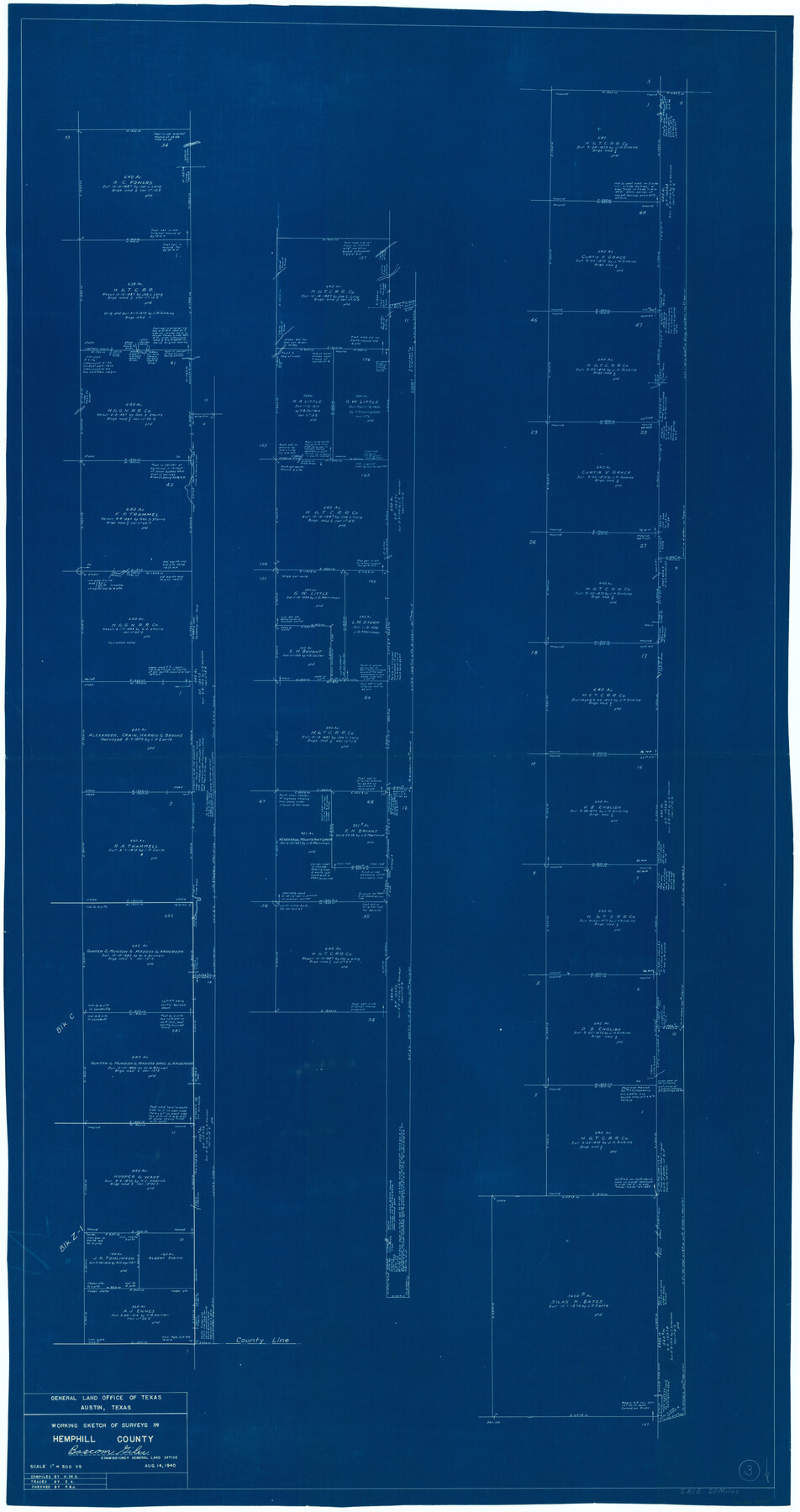
Hemphill County Working Sketch 3
-
Map/Doc
66098
-
Collection
General Map Collection
-
Object Dates
8/14/1940 (Creation Date)
-
People and Organizations
Herbert de Synek (Compiler)
Eltea Armstrong (Tracer)
-
Counties
Hemphill
-
Subjects
Surveying Working Sketch
-
Height x Width
51.8 x 27.4 inches
131.6 x 69.6 cm
-
Scale
1" = 500 varas
Part of: General Map Collection
Ector County Boundary File 4

Print $4.00
- Digital $50.00
Ector County Boundary File 4
Size 13.3 x 8.2 inches
Map/Doc 52845
Bandera County Working Sketch 13

Print $20.00
- Digital $50.00
Bandera County Working Sketch 13
1932
Size 29.1 x 25.3 inches
Map/Doc 67606
Flight Mission No. BRA-16M, Frame 50, Jefferson County

Print $20.00
- Digital $50.00
Flight Mission No. BRA-16M, Frame 50, Jefferson County
1953
Size 18.5 x 22.5 inches
Map/Doc 85667
Flight Mission No. CRK-3P, Frame 129, Refugio County

Print $20.00
- Digital $50.00
Flight Mission No. CRK-3P, Frame 129, Refugio County
1956
Size 18.5 x 22.4 inches
Map/Doc 86917
Morris County Rolled Sketch 2

Print $40.00
- Digital $50.00
Morris County Rolled Sketch 2
1944
Size 59.4 x 43.5 inches
Map/Doc 9550
Flight Mission No. BQR-13K, Frame 23, Brazoria County

Print $20.00
- Digital $50.00
Flight Mission No. BQR-13K, Frame 23, Brazoria County
1952
Size 18.9 x 22.4 inches
Map/Doc 84071
Red River County Sketch File A

Print $40.00
- Digital $50.00
Red River County Sketch File A
1900
Size 20.1 x 23.8 inches
Map/Doc 12236
Polk County Rolled Sketch TS

Print $40.00
- Digital $50.00
Polk County Rolled Sketch TS
1937
Size 37.9 x 58.9 inches
Map/Doc 9755
Brazos River, Brazos River Sheet 7

Print $20.00
- Digital $50.00
Brazos River, Brazos River Sheet 7
1926
Size 22.8 x 27.8 inches
Map/Doc 69671
Taylor County Working Sketch 12

Print $20.00
- Digital $50.00
Taylor County Working Sketch 12
1956
Size 25.5 x 26.9 inches
Map/Doc 69622
Aransas County NRC Article 33.136 Sketch 11

Print $54.00
- Digital $50.00
Aransas County NRC Article 33.136 Sketch 11
2012
Size 36.0 x 48.0 inches
Map/Doc 94502
Matagorda County Sketch File 15

Print $48.00
- Digital $50.00
Matagorda County Sketch File 15
Size 8.7 x 11.2 inches
Map/Doc 30774
You may also like
Duval County Boundary File 1b

Print $48.00
- Digital $50.00
Duval County Boundary File 1b
1877
Size 12.6 x 8.0 inches
Map/Doc 52679
Potter County Boundary File 5

Print $24.00
- Digital $50.00
Potter County Boundary File 5
Size 15.0 x 9.4 inches
Map/Doc 58013
General Highway Map, Harrison County, Texas

Print $20.00
General Highway Map, Harrison County, Texas
1961
Size 18.3 x 24.8 inches
Map/Doc 79509
Harrison County Rolled Sketch 4

Print $20.00
- Digital $50.00
Harrison County Rolled Sketch 4
1938
Size 28.2 x 34.9 inches
Map/Doc 6150
Crockett County Working Sketch 30

Print $20.00
- Digital $50.00
Crockett County Working Sketch 30
1924
Size 30.1 x 22.1 inches
Map/Doc 68363
Controlled Mosaic by Jack Amman Photogrammetric Engineers, Inc - Sheet 10

Print $20.00
- Digital $50.00
Controlled Mosaic by Jack Amman Photogrammetric Engineers, Inc - Sheet 10
1954
Size 20.0 x 24.0 inches
Map/Doc 83454
Map of Hays County

Print $20.00
- Digital $50.00
Map of Hays County
1880
Size 26.0 x 21.8 inches
Map/Doc 4562
Sutton County Sketch File 38

Print $20.00
- Digital $50.00
Sutton County Sketch File 38
1935
Size 18.2 x 28.3 inches
Map/Doc 12388
Genl. Austins Map of Texas With Parts of the Adjoining States

Print $20.00
- Digital $50.00
Genl. Austins Map of Texas With Parts of the Adjoining States
1840
Size 28.5 x 23.4 inches
Map/Doc 2116
Travis County

Print $40.00
- Digital $50.00
Travis County
1936
Size 46.9 x 54.1 inches
Map/Doc 95479
Plat of Surveys in Hidalgo Co.

Print $20.00
- Digital $50.00
Plat of Surveys in Hidalgo Co.
Size 18.3 x 9.2 inches
Map/Doc 75548
