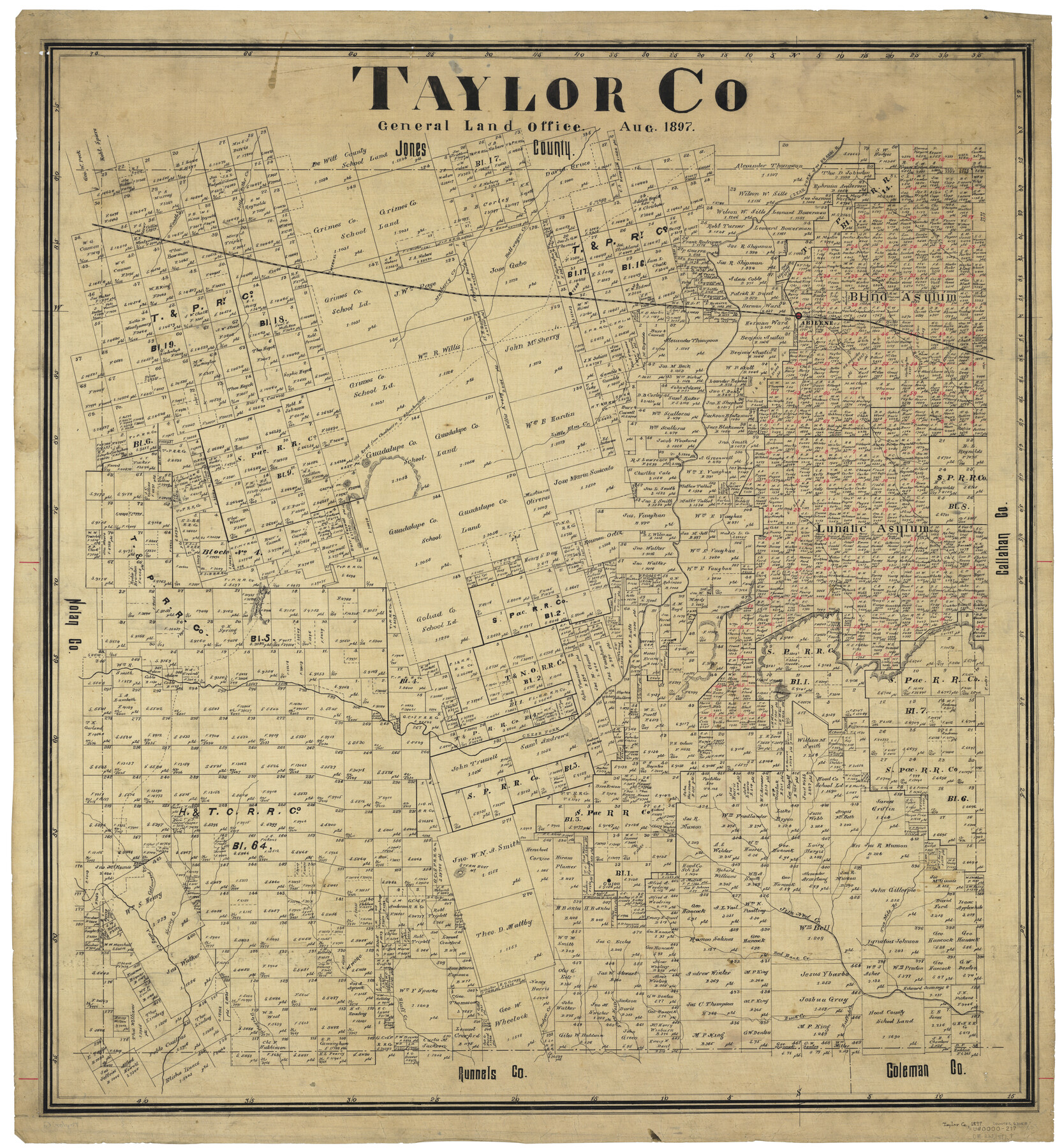
Taylor Co.
-
Map/Doc
63058
-
Collection
General Map Collection
-
Object Dates
8/1897 (Creation Date)
-
Counties
Taylor
-
Subjects
County
-
Height x Width
37.6 x 34.8 inches
95.5 x 88.4 cm
Part of: General Map Collection
Texas & Pacific Ry Reserve west of the Pecos River

Print $40.00
- Digital $50.00
Texas & Pacific Ry Reserve west of the Pecos River
1880
Size 43.9 x 90.6 inches
Map/Doc 3047
Somervell County Working Sketch 2

Print $20.00
- Digital $50.00
Somervell County Working Sketch 2
1951
Size 22.4 x 23.8 inches
Map/Doc 63906
Hardeman County Sketch File 13

Print $20.00
- Digital $50.00
Hardeman County Sketch File 13
Size 26.3 x 23.7 inches
Map/Doc 11625
Montague County Working Sketch 24

Print $20.00
- Digital $50.00
Montague County Working Sketch 24
1953
Size 21.9 x 27.6 inches
Map/Doc 71090
Mitchell County

Print $20.00
- Digital $50.00
Mitchell County
1889
Size 42.3 x 35.7 inches
Map/Doc 10792
Anderson County Sketch File 4a

Print $9.00
- Digital $50.00
Anderson County Sketch File 4a
1849
Size 9.5 x 12.0 inches
Map/Doc 12746
Map of Fort Worth

Print $40.00
- Digital $50.00
Map of Fort Worth
1902
Size 61.3 x 34.8 inches
Map/Doc 93274
Eastland County Working Sketch 1

Print $3.00
- Digital $50.00
Eastland County Working Sketch 1
1907
Size 13.8 x 11.0 inches
Map/Doc 68782
Anderson County Working Sketch 7

Print $20.00
- Digital $50.00
Anderson County Working Sketch 7
1920
Size 27.3 x 30.2 inches
Map/Doc 67006
[Beaumont, Sour Lake and Western Ry. Right of Way and Alignment - Frisco]
![64118, [Beaumont, Sour Lake and Western Ry. Right of Way and Alignment - Frisco], General Map Collection](https://historictexasmaps.com/wmedia_w700/maps/64118.tif.jpg)
Print $20.00
- Digital $50.00
[Beaumont, Sour Lake and Western Ry. Right of Way and Alignment - Frisco]
1910
Size 20.1 x 46.1 inches
Map/Doc 64118
Real County Rolled Sketch 12

Print $40.00
- Digital $50.00
Real County Rolled Sketch 12
Size 42.7 x 54.6 inches
Map/Doc 9836
Pecos County Working Sketch 57

Print $20.00
- Digital $50.00
Pecos County Working Sketch 57
1949
Size 24.2 x 26.4 inches
Map/Doc 71529
You may also like
Hudspeth County Working Sketch 14

Print $20.00
- Digital $50.00
Hudspeth County Working Sketch 14
1953
Size 24.2 x 41.2 inches
Map/Doc 66296
Flight Mission No. CRC-2R, Frame 187, Chambers County

Print $20.00
- Digital $50.00
Flight Mission No. CRC-2R, Frame 187, Chambers County
1956
Size 18.6 x 22.4 inches
Map/Doc 84765
Comanche County Boundary File 2a

Print $4.00
- Digital $50.00
Comanche County Boundary File 2a
Size 14.3 x 8.8 inches
Map/Doc 51788
Palo Pinto County Sketch File 4

Print $4.00
- Digital $50.00
Palo Pinto County Sketch File 4
1870
Size 8.2 x 12.9 inches
Map/Doc 33394
Palo Pinto County Rolled Sketch 10

Print $20.00
- Digital $50.00
Palo Pinto County Rolled Sketch 10
1954
Size 35.4 x 34.1 inches
Map/Doc 9676
Trinity County Sketch File 43

Print $40.00
- Digital $50.00
Trinity County Sketch File 43
1854
Size 19.2 x 23.6 inches
Map/Doc 12495
Clay County Sketch File 40

Print $12.00
- Digital $50.00
Clay County Sketch File 40
Size 11.3 x 8.5 inches
Map/Doc 18476
Outer Continental Shelf Leasing Maps (Texas Offshore Operations)

Print $20.00
- Digital $50.00
Outer Continental Shelf Leasing Maps (Texas Offshore Operations)
Size 19.4 x 18.5 inches
Map/Doc 75849
Gregg County Working Sketch Graphic Index

Print $20.00
- Digital $50.00
Gregg County Working Sketch Graphic Index
1933
Size 32.4 x 29.5 inches
Map/Doc 76559
H No. 2 - Preliminary Sketch of Mobile Bay

Print $20.00
- Digital $50.00
H No. 2 - Preliminary Sketch of Mobile Bay
1852
Size 19.4 x 15.2 inches
Map/Doc 97223
Plat of a survey of the North part of section 16, Block 362, Martha McBride, Presidio County, Texas

Print $20.00
- Digital $50.00
Plat of a survey of the North part of section 16, Block 362, Martha McBride, Presidio County, Texas
1989
Size 24.3 x 36.1 inches
Map/Doc 60523
Dawson County Sketch File 25

Print $4.00
- Digital $50.00
Dawson County Sketch File 25
1950
Size 11.9 x 8.9 inches
Map/Doc 20581