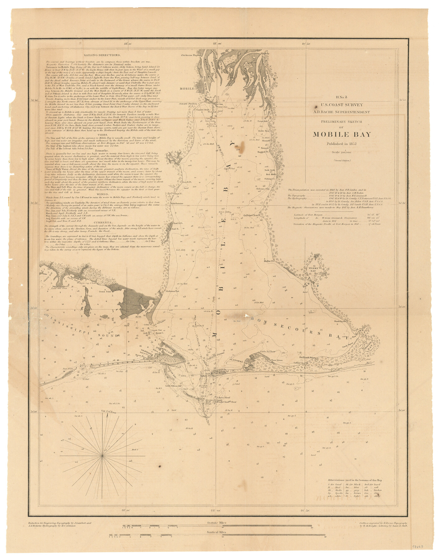
H No. 2 - Preliminary Sketch of Mobile Bay
-
Map/Doc
97223
-
Collection
General Map Collection
-
Object Dates
1852 (Creation Date)
-
People and Organizations
A.D. Bache (Superintendent)
U.S. Coast Survey (Publisher)
-
Subjects
Coastal
-
Height x Width
19.4 x 15.2 inches
49.3 x 38.6 cm
-
Comments
Sketch from the book "Report of the Superintendent of the Coast Survey Showing the Progress of the Survey in the year 1852" (81738)
Related maps
Report of the Superintendent of the Coast Survey showing the progress of the survey during the year 1852

Report of the Superintendent of the Coast Survey showing the progress of the survey during the year 1852
1853
Map/Doc 81738
Part of: General Map Collection
Flight Mission No. CGI-4N, Frame 27, Cameron County

Print $20.00
- Digital $50.00
Flight Mission No. CGI-4N, Frame 27, Cameron County
1954
Size 18.6 x 22.5 inches
Map/Doc 84660
Freestone County Working Sketch 23

Print $20.00
- Digital $50.00
Freestone County Working Sketch 23
1982
Size 20.1 x 17.0 inches
Map/Doc 69265
Bowie County Sketch File 8e

Print $12.00
- Digital $50.00
Bowie County Sketch File 8e
1928
Size 8.0 x 5.2 inches
Map/Doc 14896
Caddo Lake and Subdivision

Print $20.00
- Digital $50.00
Caddo Lake and Subdivision
1918
Size 35.0 x 29.8 inches
Map/Doc 93283
Flight Mission No. CRC-2R, Frame 109, Chambers County

Print $20.00
- Digital $50.00
Flight Mission No. CRC-2R, Frame 109, Chambers County
1956
Size 18.6 x 22.3 inches
Map/Doc 84736
Bee County Rolled Sketch 1

Print $20.00
- Digital $50.00
Bee County Rolled Sketch 1
2022
Size 24.4 x 36.0 inches
Map/Doc 97029
Shelby County Working Sketch 1

Print $20.00
- Digital $50.00
Shelby County Working Sketch 1
1917
Size 26.2 x 30.0 inches
Map/Doc 63854
Val Verde County Working Sketch 31

Print $20.00
- Digital $50.00
Val Verde County Working Sketch 31
1938
Size 19.2 x 15.3 inches
Map/Doc 72166
Colorado County Sketch File 5

Print $4.00
- Digital $50.00
Colorado County Sketch File 5
Size 12.5 x 8.3 inches
Map/Doc 18919
Terrell County Rolled Sketch 56

Print $20.00
- Digital $50.00
Terrell County Rolled Sketch 56
1986
Size 36.6 x 42.0 inches
Map/Doc 9992
Flight Mission No. CUG-1P, Frame 27, Kleberg County

Print $20.00
- Digital $50.00
Flight Mission No. CUG-1P, Frame 27, Kleberg County
1956
Size 18.4 x 22.1 inches
Map/Doc 86117
Starr County Sketch File 33

Print $8.00
- Digital $50.00
Starr County Sketch File 33
1938
Size 14.3 x 8.8 inches
Map/Doc 36971
You may also like
Jeff Davis County Working Sketch 30

Print $20.00
- Digital $50.00
Jeff Davis County Working Sketch 30
1969
Size 36.1 x 31.2 inches
Map/Doc 66525
Township 15 South Range 15 West and Fractional Township 16 South Range 15 West, South Western District, Louisiana

Print $20.00
- Digital $50.00
Township 15 South Range 15 West and Fractional Township 16 South Range 15 West, South Western District, Louisiana
1875
Size 19.6 x 24.7 inches
Map/Doc 65861
[B. S. & F. Block M7]
![90393, [B. S. & F. Block M7], Twichell Survey Records](https://historictexasmaps.com/wmedia_w700/maps/90393-1.tif.jpg)
Print $20.00
- Digital $50.00
[B. S. & F. Block M7]
1905
Size 21.7 x 17.9 inches
Map/Doc 90393
Maps of Gulf Intracoastal Waterway, Texas - Sabine River to the Rio Grande and connecting waterways including ship channels

Print $20.00
- Digital $50.00
Maps of Gulf Intracoastal Waterway, Texas - Sabine River to the Rio Grande and connecting waterways including ship channels
1966
Size 15.7 x 22.0 inches
Map/Doc 61983
Map of Sabine County

Print $20.00
- Digital $50.00
Map of Sabine County
1896
Size 25.8 x 17.9 inches
Map/Doc 63012
[Southeast Corner of Glasscock County]
![90786, [Southeast Corner of Glasscock County], Twichell Survey Records](https://historictexasmaps.com/wmedia_w700/maps/90786-1.tif.jpg)
Print $20.00
- Digital $50.00
[Southeast Corner of Glasscock County]
Size 19.2 x 22.5 inches
Map/Doc 90786

Nueces River, Bluntzer Sheet

Print $20.00
- Digital $50.00
Nueces River, Bluntzer Sheet
1927
Size 35.3 x 42.9 inches
Map/Doc 65088
Gulf Intracoastal Waterway, Tex. - Aransas Bay to Corpus Christi Bay - Modified Route of Main Channel/Dredging

Print $20.00
- Digital $50.00
Gulf Intracoastal Waterway, Tex. - Aransas Bay to Corpus Christi Bay - Modified Route of Main Channel/Dredging
1958
Size 31.0 x 42.8 inches
Map/Doc 61893
Map of east part of West Bay & SW part of Galveston Bay, Galveston County showing subdivision for mineral development

Print $40.00
- Digital $50.00
Map of east part of West Bay & SW part of Galveston Bay, Galveston County showing subdivision for mineral development
1963
Size 64.1 x 45.4 inches
Map/Doc 3079
Cottle County Working Sketch 9

Print $20.00
- Digital $50.00
Cottle County Working Sketch 9
1919
Size 33.3 x 32.1 inches
Map/Doc 68319
Reeves County Working Sketch 14

Print $20.00
- Digital $50.00
Reeves County Working Sketch 14
1960
Size 26.5 x 24.9 inches
Map/Doc 63457