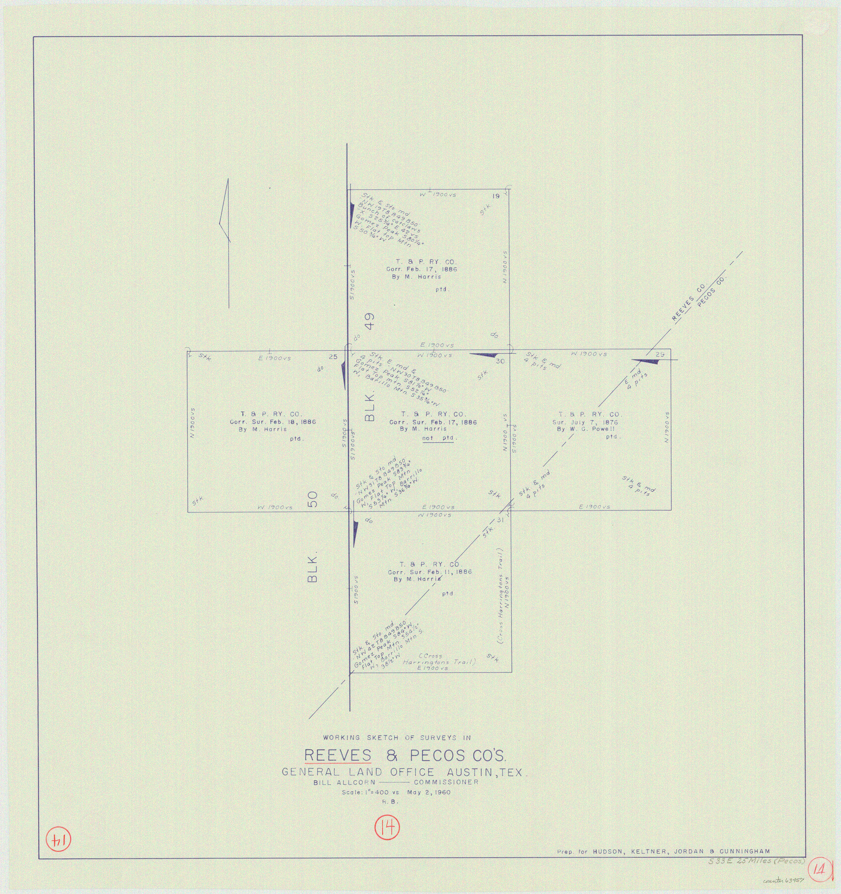
Reeves County Working Sketch 14
-
Map/Doc
63457
-
Collection
General Map Collection
-
Object Dates
5/2/1960 (Creation Date)
-
People and Organizations
Roy Buckholts (Draftsman)
-
Counties
Reeves Pecos
-
Subjects
Surveying Working Sketch
-
Height x Width
26.5 x 24.9 inches
67.3 x 63.3 cm
-
Scale
1" = 400 varas
Part of: General Map Collection
Montgomery County Working Sketch 62

Print $20.00
- Digital $50.00
Montgomery County Working Sketch 62
1963
Size 18.1 x 21.3 inches
Map/Doc 71169
Flight Mission No. BRE-2P, Frame 10, Nueces County

Print $20.00
- Digital $50.00
Flight Mission No. BRE-2P, Frame 10, Nueces County
1956
Size 17.9 x 21.5 inches
Map/Doc 86719
Wharton County Working Sketch 2

Print $20.00
- Digital $50.00
Wharton County Working Sketch 2
Size 29.3 x 37.3 inches
Map/Doc 72466
Flight Mission No. BQY-4M, Frame 119, Harris County

Print $20.00
- Digital $50.00
Flight Mission No. BQY-4M, Frame 119, Harris County
1953
Size 18.7 x 22.4 inches
Map/Doc 85287
Pecos County Working Sketch 137

Print $20.00
- Digital $50.00
Pecos County Working Sketch 137
1981
Size 32.3 x 28.4 inches
Map/Doc 71611
Flight Mission No. CLL-3N, Frame 4, Willacy County

Print $20.00
- Digital $50.00
Flight Mission No. CLL-3N, Frame 4, Willacy County
1954
Size 18.5 x 22.0 inches
Map/Doc 87070
Reagan County Rolled Sketch 27

Print $40.00
- Digital $50.00
Reagan County Rolled Sketch 27
Size 66.0 x 47.2 inches
Map/Doc 9821
Val Verde County Working Sketch 39

Print $20.00
- Digital $50.00
Val Verde County Working Sketch 39
1943
Size 26.0 x 26.5 inches
Map/Doc 72174
Hardin County Working Sketch 11

Print $20.00
- Digital $50.00
Hardin County Working Sketch 11
1929
Size 25.4 x 24.1 inches
Map/Doc 63409
General Chart of the Coast No. XXI Gulf Coast from Galveston to the Rio Grande

Print $20.00
- Digital $50.00
General Chart of the Coast No. XXI Gulf Coast from Galveston to the Rio Grande
1883
Size 27.1 x 18.2 inches
Map/Doc 72730
Crockett County Sketch File 56

Print $20.00
- Digital $50.00
Crockett County Sketch File 56
Size 19.6 x 19.0 inches
Map/Doc 11224
Map of Hill County

Print $40.00
- Digital $50.00
Map of Hill County
1884
Size 48.4 x 37.7 inches
Map/Doc 4979
You may also like
Flight Mission No. BRE-3P, Frame 93, Nueces County

Print $20.00
- Digital $50.00
Flight Mission No. BRE-3P, Frame 93, Nueces County
1956
Size 18.6 x 22.6 inches
Map/Doc 86824
Webb County Working Sketch 5

Print $20.00
- Digital $50.00
Webb County Working Sketch 5
1909
Size 20.1 x 15.4 inches
Map/Doc 72370
Map of Val Verde County

Print $40.00
- Digital $50.00
Map of Val Verde County
1898
Size 81.6 x 30.7 inches
Map/Doc 82013
Hood County Rolled Sketch 2

Print $20.00
- Digital $50.00
Hood County Rolled Sketch 2
1958
Size 18.0 x 27.4 inches
Map/Doc 6219
Notes for map of Montgomery County

Print $20.00
- Digital $50.00
Notes for map of Montgomery County
1844
Size 17.6 x 21.9 inches
Map/Doc 78370
Kendall County Working Sketch 27

Print $20.00
- Digital $50.00
Kendall County Working Sketch 27
1994
Size 30.8 x 42.6 inches
Map/Doc 66699
[East Part of Block 37, Township 2 North]
![91395, [East Part of Block 37, Township 2 North], Twichell Survey Records](https://historictexasmaps.com/wmedia_w700/maps/91395-1.tif.jpg)
Print $3.00
- Digital $50.00
[East Part of Block 37, Township 2 North]
Size 9.6 x 17.6 inches
Map/Doc 91395
Collin County Sketch File 3

Print $20.00
- Digital $50.00
Collin County Sketch File 3
1852
Size 19.5 x 21.4 inches
Map/Doc 11126
Dimmit County Sketch File 45

Print $20.00
- Digital $50.00
Dimmit County Sketch File 45
1905
Size 24.9 x 25.5 inches
Map/Doc 11355
Tom Green County Rolled Sketch 16

Print $20.00
- Digital $50.00
Tom Green County Rolled Sketch 16
1954
Size 38.2 x 44.6 inches
Map/Doc 10004
Fort Bend County Sketch File 21

Print $4.00
- Digital $50.00
Fort Bend County Sketch File 21
1882
Size 8.8 x 13.4 inches
Map/Doc 22954
Karnes County, Texas

Print $20.00
- Digital $50.00
Karnes County, Texas
1880
Size 28.9 x 23.0 inches
Map/Doc 524