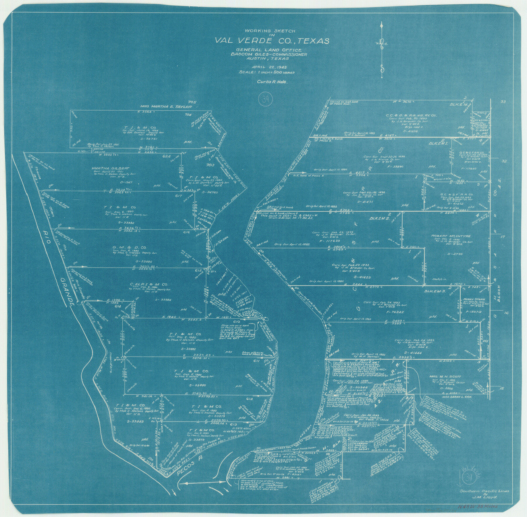
Val Verde County Working Sketch 39
-
Map/Doc
72174
-
Collection
General Map Collection
-
Object Dates
4/22/1943 (Creation Date)
-
People and Organizations
Curtis R. Hale (Draftsman)
-
Counties
Val Verde
-
Subjects
Surveying Working Sketch
-
Height x Width
26.0 x 26.5 inches
66.0 x 67.3 cm
-
Scale
1" = 500 varas
Part of: General Map Collection
Webb County Sketch File 7-2

Print $20.00
- Digital $50.00
Webb County Sketch File 7-2
1927
Size 31.6 x 23.7 inches
Map/Doc 12618

Flight Mission No. DQN-7K, Frame 11, Calhoun County

Print $20.00
- Digital $50.00
Flight Mission No. DQN-7K, Frame 11, Calhoun County
1953
Size 18.6 x 22.3 inches
Map/Doc 84462
Kent County Sketch File 3

Print $4.00
- Digital $50.00
Kent County Sketch File 3
Size 14.2 x 8.7 inches
Map/Doc 28825
Concho County Sketch File 47

Print $20.00
- Digital $50.00
Concho County Sketch File 47
1950
Size 16.8 x 21.0 inches
Map/Doc 11165
Hutchinson County Rolled Sketch 42

Print $40.00
- Digital $50.00
Hutchinson County Rolled Sketch 42
1993
Size 38.0 x 49.5 inches
Map/Doc 6310
Brazoria County Sketch File 9

Print $6.00
- Digital $50.00
Brazoria County Sketch File 9
Size 14.0 x 9.0 inches
Map/Doc 14936
Stephens County Sketch File 2

Print $4.00
- Digital $50.00
Stephens County Sketch File 2
1870
Size 12.9 x 8.2 inches
Map/Doc 37013
Coast Chart No. 211 - Padre I. and Laguna Madre, Lat. 27° 12' to Lat. 26° 33', Texas

Print $20.00
- Digital $50.00
Coast Chart No. 211 - Padre I. and Laguna Madre, Lat. 27° 12' to Lat. 26° 33', Texas
1890
Size 40.1 x 33.7 inches
Map/Doc 73500
Morris County Working Sketch 5

Print $20.00
- Digital $50.00
Morris County Working Sketch 5
1965
Size 24.7 x 18.9 inches
Map/Doc 71204
Presidio County Working Sketch 28

Print $20.00
- Digital $50.00
Presidio County Working Sketch 28
1945
Size 19.9 x 13.4 inches
Map/Doc 71704
Cameron County Rolled Sketch 13

Print $40.00
- Digital $50.00
Cameron County Rolled Sketch 13
1952
Size 39.2 x 62.1 inches
Map/Doc 8567
You may also like
Montague County Sketch File 4

Print $22.00
- Digital $50.00
Montague County Sketch File 4
1855
Size 12.7 x 16.1 inches
Map/Doc 31715
Subdivisions of Hall County School Land situated in Bailey and Cockran (sic) Counties, Texas owned by G. T. Oliver, Amarillo, Tex.

Print $2.00
- Digital $50.00
Subdivisions of Hall County School Land situated in Bailey and Cockran (sic) Counties, Texas owned by G. T. Oliver, Amarillo, Tex.
1907
Size 8.2 x 15.7 inches
Map/Doc 90477
Pecos County Rolled Sketch 141

Print $40.00
- Digital $50.00
Pecos County Rolled Sketch 141
1927
Size 60.5 x 20.4 inches
Map/Doc 10722
Childress County Sketch File 1

Print $16.00
- Digital $50.00
Childress County Sketch File 1
1877
Size 12.8 x 8.3 inches
Map/Doc 18235
Atascosa County Sketch File 11

Print $4.00
- Digital $50.00
Atascosa County Sketch File 11
1856
Size 10.8 x 8.6 inches
Map/Doc 13767
Winkler County Working Sketch Graphic Index

Print $20.00
- Digital $50.00
Winkler County Working Sketch Graphic Index
1932
Size 36.4 x 36.4 inches
Map/Doc 76744
Liberty County Rolled Sketch Q

Print $20.00
- Digital $50.00
Liberty County Rolled Sketch Q
1890
Size 31.7 x 25.1 inches
Map/Doc 6625
Sketch of coast of Texas, Laguna Madre from Pt. of Rocks to Corpus Christi [and accompanying letter]
![72962, Sketch of coast of Texas, Laguna Madre from Pt. of Rocks to Corpus Christi [and accompanying letter], General Map Collection](https://historictexasmaps.com/wmedia_w700/maps/72962.tif.jpg)
Print $20.00
- Digital $50.00
Sketch of coast of Texas, Laguna Madre from Pt. of Rocks to Corpus Christi [and accompanying letter]
1881
Size 26.5 x 18.3 inches
Map/Doc 72962
Kimble County Working Sketch 50

Print $20.00
- Digital $50.00
Kimble County Working Sketch 50
1952
Size 34.8 x 22.1 inches
Map/Doc 70118
Maps of Gulf Intracoastal Waterway, Texas - Sabine River to the Rio Grande and connecting waterways including ship channels

Print $20.00
- Digital $50.00
Maps of Gulf Intracoastal Waterway, Texas - Sabine River to the Rio Grande and connecting waterways including ship channels
1966
Size 14.6 x 22.4 inches
Map/Doc 61924
Sulphur River, North Extension, Turner Lake Sheet

Print $4.00
- Digital $50.00
Sulphur River, North Extension, Turner Lake Sheet
1922
Size 17.8 x 18.6 inches
Map/Doc 65158
![90713, [Capitol Lands], Twichell Survey Records](https://historictexasmaps.com/wmedia_w700/maps/90713-1.tif.jpg)