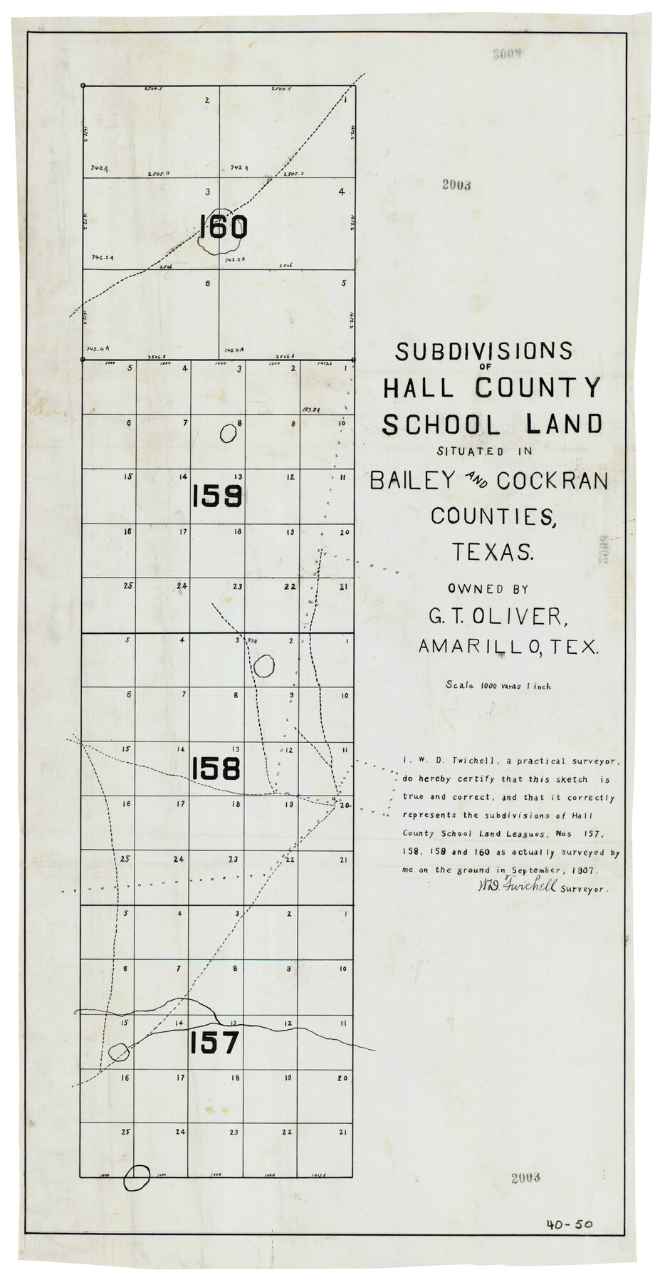
Subdivisions of Hall County School Land situated in Bailey and Cockran (sic) Counties, Texas owned by G. T. Oliver, Amarillo, Tex.
40-50
-
Map/Doc
90477
-
Collection
Twichell Survey Records
-
Object Dates
9/1907 (Creation Date)
-
People and Organizations
W.D. Twichell (Surveyor/Engineer)
-
Counties
Cochran
-
Height x Width
8.2 x 15.7 inches
20.8 x 39.9 cm
Part of: Twichell Survey Records
[PSL A31-A26-A23]
![92451, [PSL A31-A26-A23], Twichell Survey Records](https://historictexasmaps.com/wmedia_w700/maps/92451-1.tif.jpg)
Print $20.00
- Digital $50.00
[PSL A31-A26-A23]
Size 23.7 x 19.3 inches
Map/Doc 92451
Reagan County Working Sketch

Print $20.00
- Digital $50.00
Reagan County Working Sketch
1923
Size 27.0 x 17.5 inches
Map/Doc 92971
Glasscock Public Roads

Print $20.00
- Digital $50.00
Glasscock Public Roads
Size 38.3 x 36.8 inches
Map/Doc 89944
Scrivener's North-west Sub-division, Wichita County, Texas

Print $20.00
- Digital $50.00
Scrivener's North-west Sub-division, Wichita County, Texas
Size 20.0 x 26.0 inches
Map/Doc 91994

[T. & P. Blocks 43-44, Townships 1S, 2S and 1N]
![90830, [T. & P. Blocks 43-44, Townships 1S, 2S and 1N], Twichell Survey Records](https://historictexasmaps.com/wmedia_w700/maps/90830-2.tif.jpg)
Print $20.00
- Digital $50.00
[T. & P. Blocks 43-44, Townships 1S, 2S and 1N]
Size 18.8 x 22.6 inches
Map/Doc 90830
Map of Andrews

Print $20.00
- Digital $50.00
Map of Andrews
1928
Size 20.8 x 17.7 inches
Map/Doc 92452
[West and North lines of the Panhandle]
![90576, [West and North lines of the Panhandle], Twichell Survey Records](https://historictexasmaps.com/wmedia_w700/maps/90576-1.tif.jpg)
Print $20.00
- Digital $50.00
[West and North lines of the Panhandle]
1885
Size 22.0 x 32.1 inches
Map/Doc 90576
Revised Map of Pep Located on Labor 11, League 699 Texas State Capitol Lands Hockley County, Texas

Print $20.00
- Digital $50.00
Revised Map of Pep Located on Labor 11, League 699 Texas State Capitol Lands Hockley County, Texas
1927
Size 16.9 x 15.7 inches
Map/Doc 92204
[Sketch showing H. and T. C. Blocks 46 and 47]
![91735, [Sketch showing H. and T. C. Blocks 46 and 47], Twichell Survey Records](https://historictexasmaps.com/wmedia_w700/maps/91735-1.tif.jpg)
Print $20.00
- Digital $50.00
[Sketch showing H. and T. C. Blocks 46 and 47]
1884
Size 38.5 x 24.7 inches
Map/Doc 91735
![92804, [Block O], Twichell Survey Records](https://historictexasmaps.com/wmedia_w700/maps/92804-1.tif.jpg)
[R. M. Thompson Blk. T]
![90409, [R. M. Thompson Blk. T], Twichell Survey Records](https://historictexasmaps.com/wmedia_w700/maps/90409-1.tif.jpg)
Print $20.00
- Digital $50.00
[R. M. Thompson Blk. T]
Size 16.6 x 21.7 inches
Map/Doc 90409
You may also like
Kimble County Working Sketch 87

Print $20.00
- Digital $50.00
Kimble County Working Sketch 87
1974
Size 24.1 x 30.0 inches
Map/Doc 70155
Wood County Boundary File 3

Print $10.00
- Digital $50.00
Wood County Boundary File 3
Size 12.4 x 8.5 inches
Map/Doc 60162
Cooke County Boundary File 2a

Print $8.00
- Digital $50.00
Cooke County Boundary File 2a
Size 12.2 x 7.7 inches
Map/Doc 51849
Engineer's Office, Department of the Gulf Map No. 59, Texas prepared by order of Maj. Gen. N. P. Banks under direction of Capt. P. C. Hains, U. S. Engr. & Chief Engr., Dept. of the Gulf

Print $20.00
- Digital $50.00
Engineer's Office, Department of the Gulf Map No. 59, Texas prepared by order of Maj. Gen. N. P. Banks under direction of Capt. P. C. Hains, U. S. Engr. & Chief Engr., Dept. of the Gulf
1865
Size 18.2 x 27.5 inches
Map/Doc 72716
Map of Parmer County

Print $20.00
- Digital $50.00
Map of Parmer County
1900
Size 47.8 x 41.3 inches
Map/Doc 16786
Galveston County NRC Article 33.136 Sketch 60

Print $88.00
- Digital $50.00
Galveston County NRC Article 33.136 Sketch 60
2009
Size 24.0 x 36.0 inches
Map/Doc 89263
[Part of west line of I. & C. N. Block 8]
![91823, [Part of west line of I. & C. N. Block 8], Twichell Survey Records](https://historictexasmaps.com/wmedia_w700/maps/91823-1.tif.jpg)
Print $20.00
- Digital $50.00
[Part of west line of I. & C. N. Block 8]
1915
Size 20.1 x 7.3 inches
Map/Doc 91823
Crane County Working Sketch 3

Print $20.00
- Digital $50.00
Crane County Working Sketch 3
1924
Size 36.2 x 34.4 inches
Map/Doc 68280
Jefferson County Sketch File 20

Print $40.00
- Digital $50.00
Jefferson County Sketch File 20
1872
Size 12.3 x 15.0 inches
Map/Doc 28169
Upshur County Working Sketch 1

Print $20.00
- Digital $50.00
Upshur County Working Sketch 1
1934
Size 28.9 x 32.6 inches
Map/Doc 69557
Runnels County Working Sketch 18

Print $20.00
- Digital $50.00
Runnels County Working Sketch 18
1950
Size 27.9 x 31.2 inches
Map/Doc 63614
Zapata County Working Sketch 20

Print $20.00
- Digital $50.00
Zapata County Working Sketch 20
1979
Size 20.9 x 18.5 inches
Map/Doc 62071