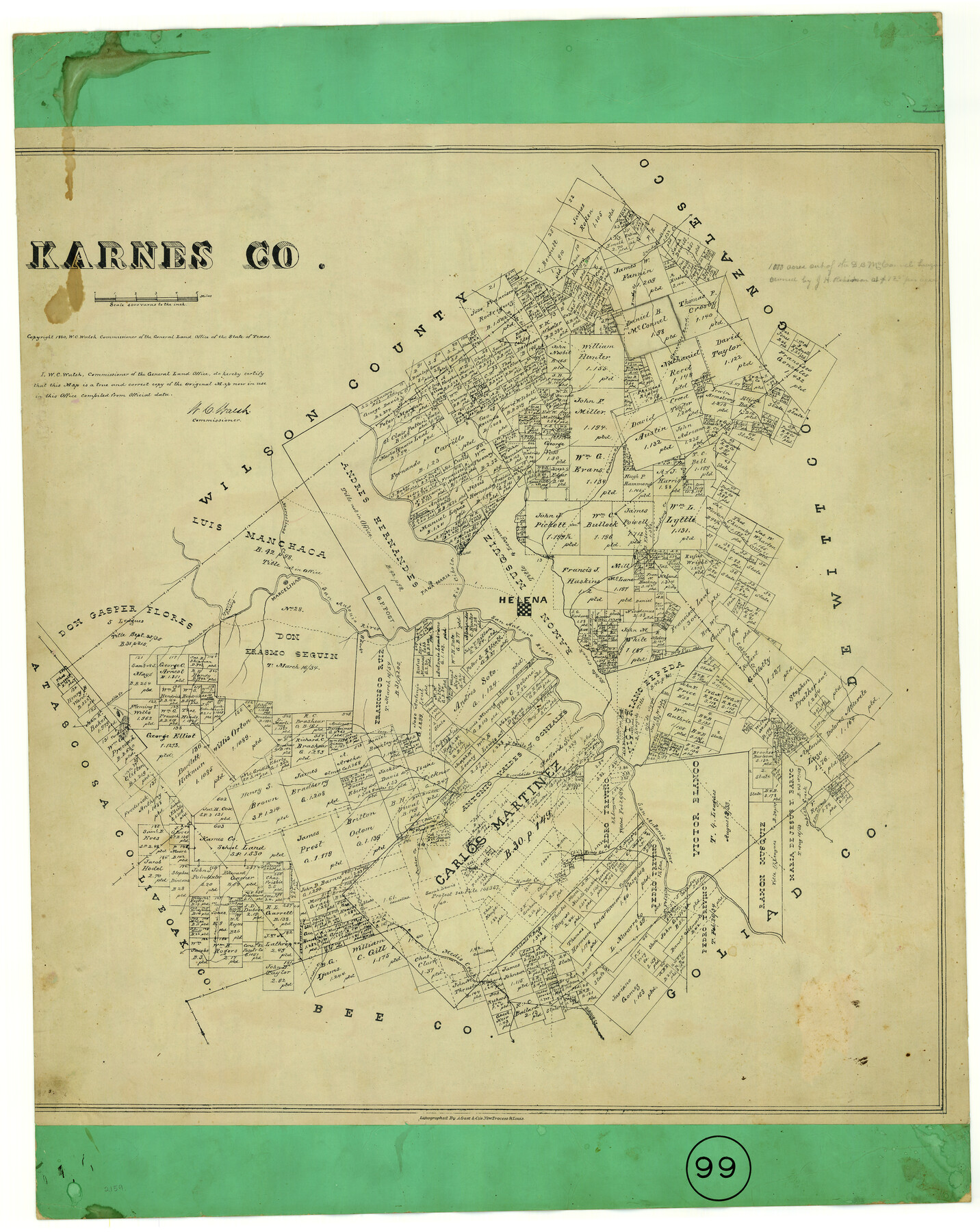
Karnes County, Texas
-
Map/Doc
524
-
Collection
Maddox Collection
-
Object Dates
1880 (Creation Date)
1880 (Copyright Date)
-
People and Organizations
General Land Office (Publisher)
W.C. Walsh (GLO Commissioner)
August Gast & Co. (Lithographer)
-
Counties
Karnes
-
Subjects
County
-
Height x Width
28.9 x 23.0 inches
73.4 x 58.4 cm
-
Medium
paper, etching/engraving/lithograph
-
Scale
1:4000
-
Comments
Conservation funded in 2002 with donation from the Time Walkers Ranch
-
Features
Cabesa [sic] Creek
Espanto Parris [Creek]
Tordillo Creek
Tordillo Mountain
Escondido Creek
Bucker Creek
Parita Creek
Ojo de Agua [Creek]
Elm Creek
Ecleto Creek
Hondo Creek
Panther Creek
San Christoval Creek
Medio Creek
Cottonwood Creek
Blanco Creek
Pedro Creek
Sandy Creek
Salt Branch [of Ecleto Creek]
Cabesa [sic] Creek
Mustang Creek
Helena
Rio Cibolo
Pana Maria
San Antonio River
Conquista Crossing
Marcelinas
Marcelinas Creek
Tonkara Creek
Carbajal Creek
Belito Creek
Brushy Creek
Gonzales Road
Part of: Maddox Collection
[Sketch showing County School Land Surveys in Throckmorton Counties, Texas]
![628, [Sketch showing County School Land Surveys in Throckmorton Counties, Texas], Maddox Collection](https://historictexasmaps.com/wmedia_w700/maps/628-GC.tif.jpg)
Print $20.00
- Digital $50.00
[Sketch showing County School Land Surveys in Throckmorton Counties, Texas]
1889
Size 15.9 x 20.2 inches
Map/Doc 628
Survey in South Austin for Mr. R.N. Graham

Print $20.00
- Digital $50.00
Survey in South Austin for Mr. R.N. Graham
1915
Size 22.6 x 33.8 inches
Map/Doc 564
Gillespie County, Texas

Print $20.00
- Digital $50.00
Gillespie County, Texas
1879
Size 21.2 x 26.9 inches
Map/Doc 547
Map of Townsite of Swearingen, Cottle County, Texas

Print $20.00
- Digital $50.00
Map of Townsite of Swearingen, Cottle County, Texas
1918
Size 28.8 x 17.4 inches
Map/Doc 4464
[Sketch Showing Surveys Adjacent to Richmond, Fort Bend County, Texas]
![395, [Sketch Showing Surveys Adjacent to Richmond, Fort Bend County, Texas], Maddox Collection](https://historictexasmaps.com/wmedia_w700/maps/0395.tif.jpg)
Print $2.00
- Digital $50.00
[Sketch Showing Surveys Adjacent to Richmond, Fort Bend County, Texas]
Size 9.9 x 7.7 inches
Map/Doc 395
Copy of sketch in Nacogdoches Donation 724 on file in GLO

Print $20.00
- Digital $50.00
Copy of sketch in Nacogdoches Donation 724 on file in GLO
1890
Size 18.0 x 10.9 inches
Map/Doc 75803
Map showing the John B. Pier Survey, Near Houston

Print $3.00
- Digital $50.00
Map showing the John B. Pier Survey, Near Houston
Size 11.9 x 17.8 inches
Map/Doc 478
Sketch compiled from records of Collin County in General Land Office

Print $3.00
- Digital $50.00
Sketch compiled from records of Collin County in General Land Office
1878
Size 11.5 x 13.5 inches
Map/Doc 504
Subdivision of the East Half of Lot No. 1 in Division "Z" of the Out-Lots adjoining the City of Austin

Print $20.00
- Digital $50.00
Subdivision of the East Half of Lot No. 1 in Division "Z" of the Out-Lots adjoining the City of Austin
Size 32.1 x 42.6 inches
Map/Doc 648
Plat of Surveys in Hidalgo Co.

Print $20.00
- Digital $50.00
Plat of Surveys in Hidalgo Co.
Size 17.3 x 8.4 inches
Map/Doc 75547
Map Showing the position of surveys 1 & 2, B.S. & F. Cert 1/356

Print $20.00
- Digital $50.00
Map Showing the position of surveys 1 & 2, B.S. & F. Cert 1/356
1915
Size 22.0 x 11.1 inches
Map/Doc 10768
Hemphill County, Texas

Print $20.00
- Digital $50.00
Hemphill County, Texas
1880
Size 19.7 x 18.6 inches
Map/Doc 549
You may also like
Kendall County Sketch File 13

Print $4.00
- Digital $50.00
Kendall County Sketch File 13
1860
Size 10.1 x 8.0 inches
Map/Doc 28699
Flight Mission No. BRA-7M, Frame 144, Jefferson County

Print $20.00
- Digital $50.00
Flight Mission No. BRA-7M, Frame 144, Jefferson County
1953
Size 18.5 x 22.3 inches
Map/Doc 85538
Lavaca County Working Sketch 1

Print $20.00
- Digital $50.00
Lavaca County Working Sketch 1
1905
Size 18.0 x 22.5 inches
Map/Doc 70354
Dickens County Sketch File G2

Print $26.00
- Digital $50.00
Dickens County Sketch File G2
1914
Size 11.4 x 8.9 inches
Map/Doc 20858
Cameron County Rolled Sketch 15

Print $40.00
- Digital $50.00
Cameron County Rolled Sketch 15
1958
Size 53.0 x 32.0 inches
Map/Doc 8568
Sterling County Rolled Sketch 19

Print $40.00
- Digital $50.00
Sterling County Rolled Sketch 19
1953
Size 53.7 x 47.7 inches
Map/Doc 9951
Richardson's New Map of the State of Texas Corrected for the Texas Almanac

Print $20.00
Richardson's New Map of the State of Texas Corrected for the Texas Almanac
1870
Size 17.8 x 25.9 inches
Map/Doc 76192
Flight Mission No. DCL-6C, Frame 181, Kenedy County

Print $20.00
- Digital $50.00
Flight Mission No. DCL-6C, Frame 181, Kenedy County
1943
Size 18.5 x 22.2 inches
Map/Doc 85993
Flight Mission No. DQN-7K, Frame 14, Calhoun County

Print $20.00
- Digital $50.00
Flight Mission No. DQN-7K, Frame 14, Calhoun County
1953
Size 17.2 x 19.1 inches
Map/Doc 84465
Map of Pass Cavallo, Texas, Showing the position of the Rebel fortifications and rifle pits.

Print $20.00
Map of Pass Cavallo, Texas, Showing the position of the Rebel fortifications and rifle pits.
1863
Size 23.8 x 21.0 inches
Map/Doc 88595
Map of Lampasas Co.

Print $20.00
- Digital $50.00
Map of Lampasas Co.
1888
Size 34.4 x 42.4 inches
Map/Doc 5080
Brewster County Sketch File NS-7

Print $14.00
- Digital $50.00
Brewster County Sketch File NS-7
1945
Size 11.3 x 8.8 inches
Map/Doc 15992