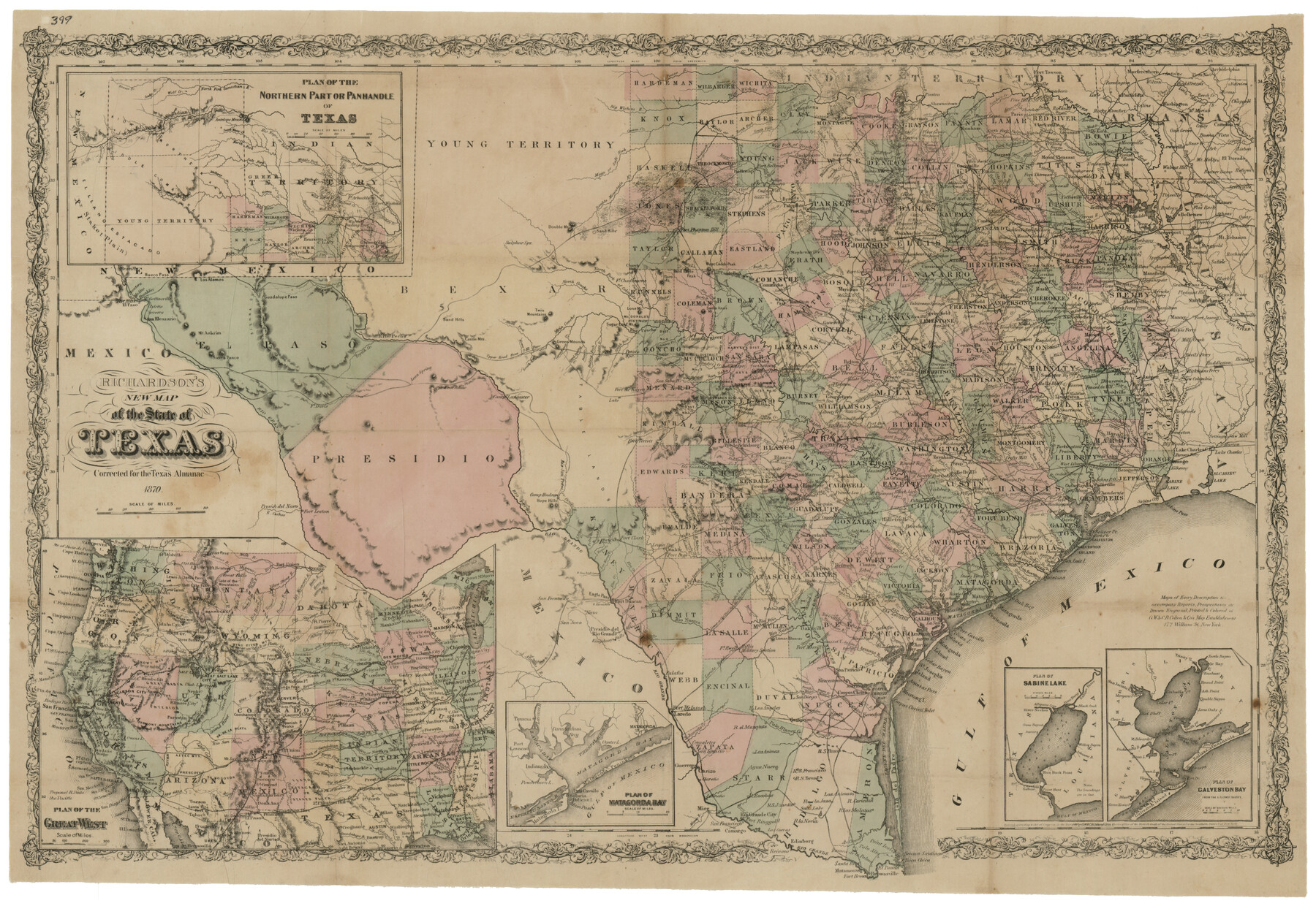
Richardson's New Map of the State of Texas Corrected for the Texas Almanac
-
Map/Doc
76192
-
Collection
Texas State Library and Archives
-
Object Dates
1870 (Creation Date)
-
People and Organizations
Richardson and Company (Publisher)
-
Subjects
State of Texas
-
Height x Width
17.8 x 25.9 inches
45.2 x 65.8 cm
-
Comments
Prints available courtesy of the Texas State Library and Archives.
More info can be found here: TSLAC Map 00399
Part of: Texas State Library and Archives
General Highway Map, Coleman County, Texas

Print $20.00
General Highway Map, Coleman County, Texas
1961
Size 24.6 x 18.3 inches
Map/Doc 79412

General Highway Map, Williamson County, Texas

Print $20.00
General Highway Map, Williamson County, Texas
1961
Size 24.8 x 18.2 inches
Map/Doc 79713
General Highway Map, Scurry County, Texas

Print $20.00
General Highway Map, Scurry County, Texas
1961
Size 18.1 x 24.8 inches
Map/Doc 79650
General Highway Map, Johnson County, Texas

Print $20.00
General Highway Map, Johnson County, Texas
1961
Size 18.2 x 24.8 inches
Map/Doc 79545
General Highway Map. Detail of Cities and Towns in Bexar County, Texas [San Antonio and vicinity]
![79018, General Highway Map. Detail of Cities and Towns in Bexar County, Texas [San Antonio and vicinity], Texas State Library and Archives](https://historictexasmaps.com/wmedia_w700/maps/79018.tif.jpg)
Print $20.00
General Highway Map. Detail of Cities and Towns in Bexar County, Texas [San Antonio and vicinity]
1940
Size 18.6 x 25.2 inches
Map/Doc 79018
General Highway Map, Wheeler County, Texas

Print $20.00
General Highway Map, Wheeler County, Texas
1961
Size 18.1 x 24.9 inches
Map/Doc 79708
General Highway Map, Brewster County, Texas

Print $20.00
General Highway Map, Brewster County, Texas
1961
Size 18.2 x 24.9 inches
Map/Doc 79385
General Highway Map, Wharton County, Texas

Print $20.00
General Highway Map, Wharton County, Texas
1940
Size 18.5 x 24.9 inches
Map/Doc 79274
Map of the River Sabine from its Mouth on the Gulf of Mexico in the Sea to Logan's Ferry in Latitude 31° 58' 25" North

Print $20.00
Map of the River Sabine from its Mouth on the Gulf of Mexico in the Sea to Logan's Ferry in Latitude 31° 58' 25" North
1840
Size 35.5 x 9.1 inches
Map/Doc 79294

General Highway Map. Detail of Cities and Towns in Smith County, Texas

Print $20.00
General Highway Map. Detail of Cities and Towns in Smith County, Texas
1961
Size 18.3 x 24.6 inches
Map/Doc 79655
You may also like
[Blocks DT, P, CK, C2, and D7]
![91307, [Blocks DT, P, CK, C2, and D7], Twichell Survey Records](https://historictexasmaps.com/wmedia_w700/maps/91307-1.tif.jpg)
Print $20.00
- Digital $50.00
[Blocks DT, P, CK, C2, and D7]
Size 23.6 x 9.6 inches
Map/Doc 91307
Lavaca County Working Sketch 2

Print $20.00
- Digital $50.00
Lavaca County Working Sketch 2
1904
Size 19.2 x 31.2 inches
Map/Doc 70355
Mills County Boundary File 5

Print $8.00
- Digital $50.00
Mills County Boundary File 5
Size 14.2 x 8.7 inches
Map/Doc 57296
Old Miscellaneous File 16

Print $28.00
- Digital $50.00
Old Miscellaneous File 16
1908
Size 9.8 x 2.6 inches
Map/Doc 75457
Map of State University Land, Pecos County, Texas

Print $20.00
- Digital $50.00
Map of State University Land, Pecos County, Texas
1929
Size 42.1 x 33.5 inches
Map/Doc 91626
Andrews County Working Sketch 5

Print $20.00
- Digital $50.00
Andrews County Working Sketch 5
1954
Size 21.7 x 43.0 inches
Map/Doc 67051
Map of Starr County

Print $40.00
- Digital $50.00
Map of Starr County
1900
Size 51.6 x 25.8 inches
Map/Doc 4046
R. H. Fulton Lands

Print $20.00
- Digital $50.00
R. H. Fulton Lands
Size 39.9 x 14.3 inches
Map/Doc 92509

Harris County Sketch File 105

Print $28.00
- Digital $50.00
Harris County Sketch File 105
1925
Size 11.2 x 9.0 inches
Map/Doc 42929
Midland County Working Sketch 32

Print $40.00
- Digital $50.00
Midland County Working Sketch 32
1971
Size 51.3 x 35.5 inches
Map/Doc 71013
Orange County Working Sketch 16

Print $20.00
- Digital $50.00
Orange County Working Sketch 16
1929
Size 25.0 x 24.2 inches
Map/Doc 71348