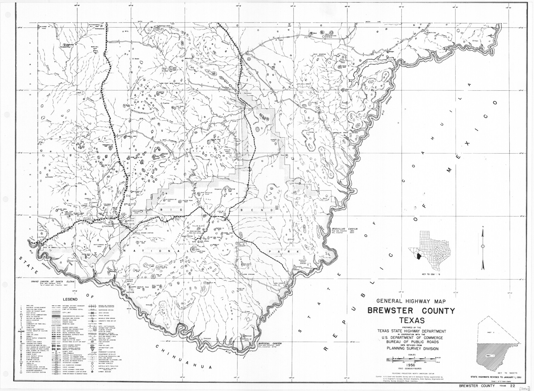
General Highway Map, Brewster County, Texas
-
Map/Doc
79385
-
Collection
Texas State Library and Archives
-
Object Dates
1961 (Creation Date)
-
People and Organizations
Texas State Highway Department (Publisher)
-
Counties
Brewster
-
Subjects
County
-
Height x Width
18.2 x 24.9 inches
46.2 x 63.3 cm
-
Comments
Prints available courtesy of the Texas State Library and Archives.
More info can be found here: TSLAC Map 05065
Part of: Texas State Library and Archives
General Highway Map, Runnels County, Texas

Print $20.00
General Highway Map, Runnels County, Texas
1940
Size 24.7 x 18.3 inches
Map/Doc 79231
General Highway Map, Hall County, Texas

Print $20.00
General Highway Map, Hall County, Texas
1961
Size 18.2 x 24.6 inches
Map/Doc 79495
General Highway Map, Borden County, Texas

Print $20.00
General Highway Map, Borden County, Texas
1940
Size 18.5 x 25.0 inches
Map/Doc 79021
General Highway Map, Roberts County, Texas

Print $20.00
General Highway Map, Roberts County, Texas
1940
Size 18.4 x 25.0 inches
Map/Doc 79229
General Highway Map. Detail of Cities and Towns in Bexar County, Texas. City Map of San Antonio, Alamo Heights, Olmos Park, Terrell Hills, Castle Hills, Balcones Heights, and vicinity, Bexar County, Texas

Print $20.00
General Highway Map. Detail of Cities and Towns in Bexar County, Texas. City Map of San Antonio, Alamo Heights, Olmos Park, Terrell Hills, Castle Hills, Balcones Heights, and vicinity, Bexar County, Texas
1961
Size 18.2 x 25.0 inches
Map/Doc 79375
General Highway Map. Detail of Cities and Towns in Dallas County, Texas [Dallas and vicinity]
![79069, General Highway Map. Detail of Cities and Towns in Dallas County, Texas [Dallas and vicinity], Texas State Library and Archives](https://historictexasmaps.com/wmedia_w700/maps/79069.tif.jpg)
Print $20.00
General Highway Map. Detail of Cities and Towns in Dallas County, Texas [Dallas and vicinity]
1936
Size 18.4 x 25.2 inches
Map/Doc 79069
General Highway Map, Jackson County, Texas

Print $20.00
General Highway Map, Jackson County, Texas
1940
Size 18.3 x 24.8 inches
Map/Doc 79140
General Highway Map, Erath County, Texas

Print $20.00
General Highway Map, Erath County, Texas
1961
Size 24.6 x 18.2 inches
Map/Doc 79460
Map of the County and City of Galveston, Texas

Print $20.00
Map of the County and City of Galveston, Texas
1891
Size 24.5 x 34.4 inches
Map/Doc 79290
General Highway Map, Hunt County, Texas

Print $20.00
General Highway Map, Hunt County, Texas
1961
Size 24.7 x 18.2 inches
Map/Doc 79528
General Highway Map. Detail of Cities and Towns in Williamson County, Texas [Round Rock, Taylor, Georgetown]
![79714, General Highway Map. Detail of Cities and Towns in Williamson County, Texas [Round Rock, Taylor, Georgetown], Texas State Library and Archives](https://historictexasmaps.com/wmedia_w700/maps/79714.tif.jpg)
Print $20.00
General Highway Map. Detail of Cities and Towns in Williamson County, Texas [Round Rock, Taylor, Georgetown]
1961
Size 18.2 x 24.8 inches
Map/Doc 79714
General Highway Map. Detail of Cities and Towns in Harris County, Texas

Print $20.00
General Highway Map. Detail of Cities and Towns in Harris County, Texas
1961
Size 18.2 x 24.6 inches
Map/Doc 79503
You may also like
[Wm. Lewis No. 254 and Surrounding Surveys, Aransas County, Texas]
![82557, [Wm. Lewis No. 254 and Surrounding Surveys, Aransas County, Texas], Maddox Collection](https://historictexasmaps.com/wmedia_w700/maps/82557.tif.jpg)
Print $20.00
- Digital $50.00
[Wm. Lewis No. 254 and Surrounding Surveys, Aransas County, Texas]
Size 18.8 x 35.2 inches
Map/Doc 82557
Flight Mission No. CGI-4N, Frame 179, Cameron County

Print $20.00
- Digital $50.00
Flight Mission No. CGI-4N, Frame 179, Cameron County
1955
Size 18.5 x 22.2 inches
Map/Doc 84682
Jefferson County Working Sketch 12

Print $20.00
- Digital $50.00
Jefferson County Working Sketch 12
1947
Size 29.9 x 39.4 inches
Map/Doc 66555
Dallas County Boundary File 9

Print $6.00
- Digital $50.00
Dallas County Boundary File 9
2008
Map/Doc 88850
Panola County Working Sketch 4

Print $20.00
- Digital $50.00
Panola County Working Sketch 4
1938
Map/Doc 71413
Plat of South Side Addition on Section 37 Block 17, Wheeler County, Texas

Print $20.00
- Digital $50.00
Plat of South Side Addition on Section 37 Block 17, Wheeler County, Texas
Size 12.0 x 16.9 inches
Map/Doc 92103
Duval County Rolled Sketch 17

Print $20.00
- Digital $50.00
Duval County Rolled Sketch 17
1940
Size 18.9 x 17.9 inches
Map/Doc 5738

Howard County Boundary File 4

Print $16.00
- Digital $50.00
Howard County Boundary File 4
Size 9.4 x 4.3 inches
Map/Doc 55158
Coleman County Working Sketch 19

Print $20.00
- Digital $50.00
Coleman County Working Sketch 19
1953
Size 18.1 x 15.4 inches
Map/Doc 68085
Travis County Rolled Sketch 11

Print $20.00
- Digital $50.00
Travis County Rolled Sketch 11
Size 23.3 x 37.9 inches
Map/Doc 8014
Kent County Boundary File 6

Print $4.00
- Digital $50.00
Kent County Boundary File 6
Size 14.1 x 8.8 inches
Map/Doc 55868