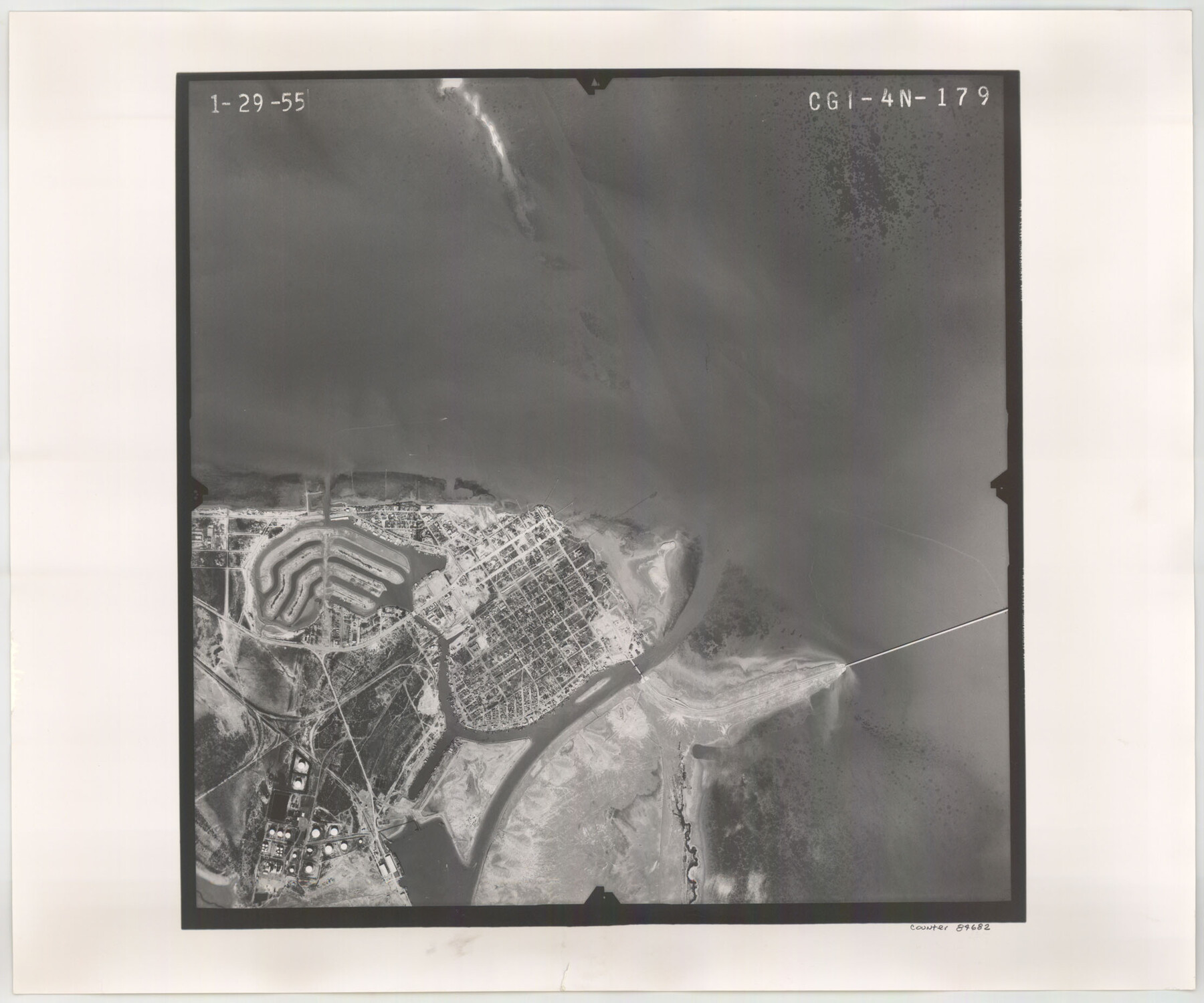
Flight Mission No. CGI-4N, Frame 179, Cameron County
CGI-4N-179
-
Map/Doc
84682
-
Collection
General Map Collection
-
Object Dates
1955/1/29 (Creation Date)
-
People and Organizations
U. S. Department of Agriculture (Publisher)
-
Counties
Cameron
-
Subjects
Aerial Photograph
-
Height x Width
18.5 x 22.2 inches
47.0 x 56.4 cm
-
Comments
Flown by Puckett Aerial Surveys, Inc. of Jackson, Mississippi.
Part of: General Map Collection
Jasper County Working Sketch 30

Print $20.00
- Digital $50.00
Jasper County Working Sketch 30
1956
Size 33.5 x 38.6 inches
Map/Doc 66492
Williamson County Working Sketch 10

Print $20.00
- Digital $50.00
Williamson County Working Sketch 10
1961
Size 31.1 x 20.0 inches
Map/Doc 72570
Fayette County Working Sketch 7

Print $20.00
- Digital $50.00
Fayette County Working Sketch 7
1981
Size 24.1 x 15.6 inches
Map/Doc 69171

Wise County Sketch File 26

Print $22.00
- Digital $50.00
Wise County Sketch File 26
1855
Size 8.1 x 14.3 inches
Map/Doc 40574
San Saba County Sketch File 5

Print $4.00
- Digital $50.00
San Saba County Sketch File 5
Size 12.8 x 8.0 inches
Map/Doc 36412
Map of Houston, Harris County, Texas

Print $20.00
- Digital $50.00
Map of Houston, Harris County, Texas
1900
Size 38.5 x 32.0 inches
Map/Doc 93390
Castro County Sketch File 8

Print $20.00
- Digital $50.00
Castro County Sketch File 8
1908
Size 27.2 x 24.0 inches
Map/Doc 11060
Flight Mission No. DQO-3K, Frame 81, Galveston County

Print $20.00
- Digital $50.00
Flight Mission No. DQO-3K, Frame 81, Galveston County
1952
Size 18.7 x 22.5 inches
Map/Doc 85086
Navarro County Working Sketch 11

Print $40.00
- Digital $50.00
Navarro County Working Sketch 11
1978
Size 53.7 x 44.4 inches
Map/Doc 71241
McCulloch County Boundary File 3

Print $16.00
- Digital $50.00
McCulloch County Boundary File 3
Size 11.1 x 8.6 inches
Map/Doc 56911
Concho County Rolled Sketch 22

Print $20.00
- Digital $50.00
Concho County Rolled Sketch 22
1971
Size 24.6 x 28.8 inches
Map/Doc 5555
You may also like
Ector County Working Sketch 18

Print $20.00
- Digital $50.00
Ector County Working Sketch 18
1957
Size 42.0 x 39.1 inches
Map/Doc 68861
Wichita County Rolled Sketch 18

Print $20.00
- Digital $50.00
Wichita County Rolled Sketch 18
1923
Size 25.7 x 38.0 inches
Map/Doc 8254
Knox County Rolled Sketch 25

Print $20.00
- Digital $50.00
Knox County Rolled Sketch 25
2007
Size 11.4 x 10.8 inches
Map/Doc 88749
Gillespie County Sketch File 3

Print $4.00
- Digital $50.00
Gillespie County Sketch File 3
1847
Size 11.2 x 8.0 inches
Map/Doc 24129
Pecos County Sketch File 27A

Print $20.00
- Digital $50.00
Pecos County Sketch File 27A
Size 26.7 x 19.8 inches
Map/Doc 12166
Atascosa County Working Sketch 30

Print $20.00
- Digital $50.00
Atascosa County Working Sketch 30
1980
Size 16.4 x 20.6 inches
Map/Doc 67226
Brazoria County Rolled Sketch 30

Print $20.00
- Digital $50.00
Brazoria County Rolled Sketch 30
1940
Size 17.8 x 22.9 inches
Map/Doc 5168
Flight Mission No. DQN-2K, Frame 7, Calhoun County

Print $20.00
- Digital $50.00
Flight Mission No. DQN-2K, Frame 7, Calhoun County
1953
Size 18.4 x 22.1 inches
Map/Doc 84224
[Sketch for Mineral Application 26501 - Sabine River, T. A. Oldhausen]
![2846, [Sketch for Mineral Application 26501 - Sabine River, T. A. Oldhausen], General Map Collection](https://historictexasmaps.com/wmedia_w700/maps/2846.tif.jpg)
Print $20.00
- Digital $50.00
[Sketch for Mineral Application 26501 - Sabine River, T. A. Oldhausen]
1931
Size 24.4 x 37.0 inches
Map/Doc 2846
Gregg County Boundary File 4

Print $14.00
- Digital $50.00
Gregg County Boundary File 4
Size 14.1 x 8.6 inches
Map/Doc 53992
Map of Brewster Co.

Print $40.00
- Digital $50.00
Map of Brewster Co.
1896
Size 58.4 x 17.3 inches
Map/Doc 4892
[Blocks S2, K3, K, and S1]
![90415, [Blocks S2, K3, K, and S1], Twichell Survey Records](https://historictexasmaps.com/wmedia_w700/maps/90415-1.tif.jpg)
Print $20.00
- Digital $50.00
[Blocks S2, K3, K, and S1]
1906
Size 17.9 x 16.4 inches
Map/Doc 90415