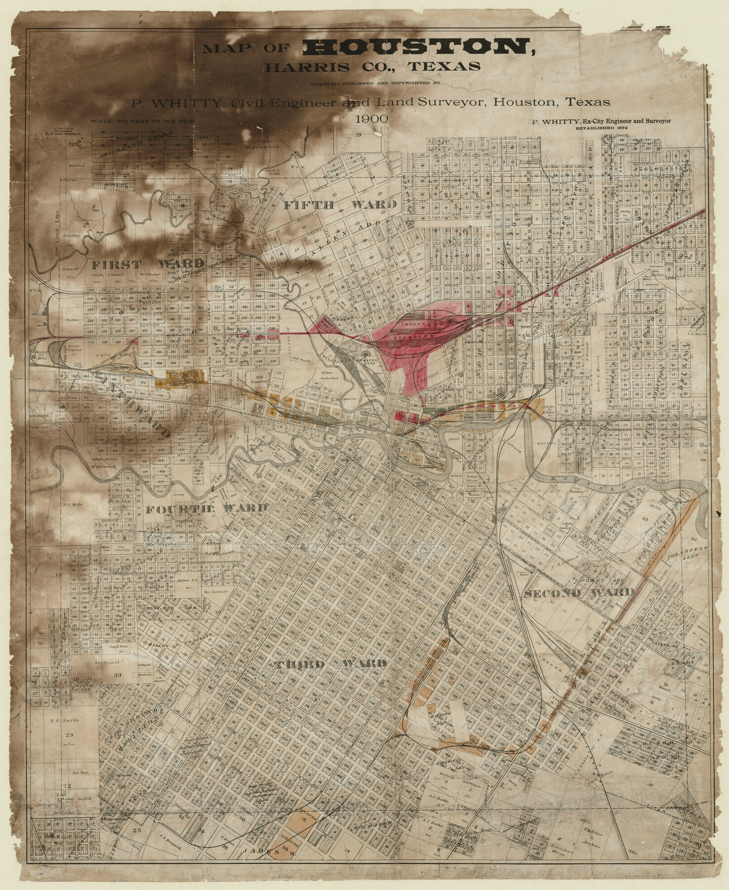
Map of Houston, Harris County, Texas
-
Map/Doc
93390
-
Collection
General Map Collection
-
Object Dates
1900 (Creation Date)
11/5/2012 (File Date)
-
People and Organizations
P. Whitty (Publisher)
Warren H. Outlaw, Jr. (Donor)
P. Whitty (Compiler)
-
Counties
Harris
-
Subjects
City
-
Height x Width
38.5 x 32.0 inches
97.8 x 81.3 cm
-
Scale
1" = 600 ft.
-
Comments
Donated by Warren H. Outlaw, Jr. in memory of Warren H. Outlaw III and conservation funded in 2012 by Friends of the Texas General Land Office.
-
Features
Presb[yterian] Ch[urch]
Proposed Extension of SA&AP RR
Rice Institute
City Cemetery
SA&AP
City Park
Episcopal Cemetery
German Methodist Church
Longfellow School
H&GN Depot
H&GN
GC&SF
Union Depot
Church of Anunciation
Houston
German Ch[urch]
Hebrew Cemetery
Bering's Mill
City Cremetory
Catholic Cemetery
Buffalo Bayou
Glenwood Cemetery
H&TC
Old Channel
GH&SA
T&NO
Bayland Orphan Home
-
URLs
https://medium.com/save-texas-history/map-of-houston-harris-county-texas-1900-aa14590fb51b
Part of: General Map Collection
Red River County Sketch File 8

Print $22.00
- Digital $50.00
Red River County Sketch File 8
Size 14.7 x 16.8 inches
Map/Doc 35112
Cooke County Sketch File 47

Print $24.00
- Digital $50.00
Cooke County Sketch File 47
2003
Size 26.6 x 18.4 inches
Map/Doc 78650
Starr County Working Sketch 1

Print $40.00
- Digital $50.00
Starr County Working Sketch 1
Size 26.7 x 65.5 inches
Map/Doc 63917
[Map of Block 97, Borden and Scurry Co (Exhibit A); Map of Southeastern part of Young Territory; Map of part of of Borden, Fisher, Kent, Mitchell, Scurry and Garza Cos. Showing the north boundary line of the T&P 80 mile reservation]
![65693, [Map of Block 97, Borden and Scurry Co (Exhibit A); Map of Southeastern part of Young Territory; Map of part of of Borden, Fisher, Kent, Mitchell, Scurry and Garza Cos. Showing the north boundary line of the T&P 80 mile reservation], General Map Collection](https://historictexasmaps.com/wmedia_w700/maps/65693.tif.jpg)
Print $20.00
- Digital $50.00
[Map of Block 97, Borden and Scurry Co (Exhibit A); Map of Southeastern part of Young Territory; Map of part of of Borden, Fisher, Kent, Mitchell, Scurry and Garza Cos. Showing the north boundary line of the T&P 80 mile reservation]
1901
Size 31.2 x 23.3 inches
Map/Doc 65693
Jeff Davis County Sketch File 8

Print $20.00
- Digital $50.00
Jeff Davis County Sketch File 8
1889
Size 19.5 x 28.5 inches
Map/Doc 11857
Potter County Working Sketch 5

Print $20.00
- Digital $50.00
Potter County Working Sketch 5
1920
Size 41.3 x 37.1 inches
Map/Doc 71665
El Paso County Rolled Sketch 45

Print $20.00
- Digital $50.00
El Paso County Rolled Sketch 45
Size 21.0 x 24.3 inches
Map/Doc 5831
Bandera County

Print $40.00
- Digital $50.00
Bandera County
1947
Size 34.2 x 54.7 inches
Map/Doc 1777
Flight Mission No. DQN-5K, Frame 47, Calhoun County

Print $20.00
- Digital $50.00
Flight Mission No. DQN-5K, Frame 47, Calhoun County
1953
Size 18.5 x 22.2 inches
Map/Doc 84392
Montgomery County

Print $20.00
- Digital $50.00
Montgomery County
1901
Size 21.9 x 25.3 inches
Map/Doc 3898
Galveston County NRC Article 33.136 Sketch 81

Print $202.00
- Digital $50.00
Galveston County NRC Article 33.136 Sketch 81
2015
Size 34.0 x 22.0 inches
Map/Doc 94976
Tom Green County Sketch File XXX

Print $20.00
- Digital $50.00
Tom Green County Sketch File XXX
Size 17.0 x 20.5 inches
Map/Doc 12457
You may also like
Harrison County Working Sketch 25

Print $20.00
- Digital $50.00
Harrison County Working Sketch 25
1983
Size 21.9 x 24.0 inches
Map/Doc 66045
The Republic County of Galveston. December 29, 1845

Print $20.00
The Republic County of Galveston. December 29, 1845
2020
Size 14.7 x 21.9 inches
Map/Doc 96146
The Republic County of Milam. December 29, 1845

Print $20.00
The Republic County of Milam. December 29, 1845
2020
Size 17.4 x 21.6 inches
Map/Doc 96233
Live Oak County Rolled Sketch 9

Print $20.00
- Digital $50.00
Live Oak County Rolled Sketch 9
1982
Size 25.6 x 23.3 inches
Map/Doc 6636
Wise County Sketch File 30

Print $6.00
- Digital $50.00
Wise County Sketch File 30
1876
Size 12.7 x 8.1 inches
Map/Doc 40579
Bee County Working Sketch 9

Print $20.00
- Digital $50.00
Bee County Working Sketch 9
1940
Size 15.6 x 16.8 inches
Map/Doc 67259
Schleicher County Sketch File 14

Print $12.00
- Digital $50.00
Schleicher County Sketch File 14
1917
Size 12.9 x 8.3 inches
Map/Doc 36498
San Jacinto County Working Sketch 13

Print $20.00
- Digital $50.00
San Jacinto County Working Sketch 13
1935
Size 25.0 x 18.8 inches
Map/Doc 63726
Crane County Rolled Sketch 18

Print $20.00
- Digital $50.00
Crane County Rolled Sketch 18
1950
Size 37.8 x 37.2 inches
Map/Doc 8683

San Patricio County Rolled Sketch 34

Print $20.00
- Digital $50.00
San Patricio County Rolled Sketch 34
Size 25.8 x 26.2 inches
Map/Doc 7584
Nueces County Sketch File 68

Print $8.00
- Digital $50.00
Nueces County Sketch File 68
Size 11.0 x 8.7 inches
Map/Doc 33000