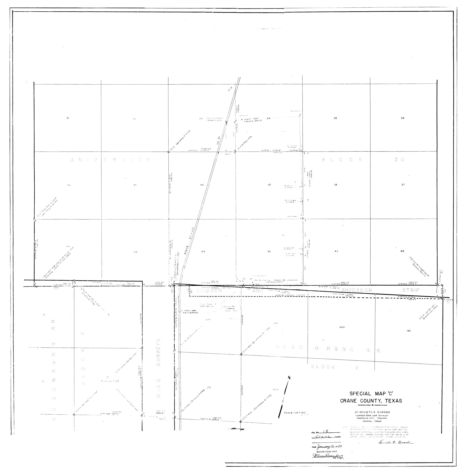
Crane County Rolled Sketch 18
Special map 'C', Crane County, Texas
-
Map/Doc
8683
-
Collection
General Map Collection
-
Object Dates
1950/1/4 (Creation Date)
1950/1/12 (File Date)
-
People and Organizations
Kenneth E. Esmond (Surveyor/Engineer)
-
Counties
Crane
-
Subjects
Surveying Rolled Sketch
-
Height x Width
37.8 x 37.2 inches
96.0 x 94.5 cm
-
Scale
1" = 100 feet
Part of: General Map Collection
Burnet County Working Sketch 17

Print $20.00
- Digital $50.00
Burnet County Working Sketch 17
1979
Size 41.1 x 34.4 inches
Map/Doc 67860
Mills County Working Sketch 9

Print $20.00
- Digital $50.00
Mills County Working Sketch 9
1915
Size 13.3 x 13.7 inches
Map/Doc 71039

Terrell County Working Sketch 19

Print $20.00
- Digital $50.00
Terrell County Working Sketch 19
1932
Size 18.6 x 25.6 inches
Map/Doc 69801
Kerr County Rolled Sketch 11

Print $20.00
- Digital $50.00
Kerr County Rolled Sketch 11
1950
Size 28.1 x 36.9 inches
Map/Doc 6495
Runnels County Rolled Sketch 34

Print $20.00
- Digital $50.00
Runnels County Rolled Sketch 34
Size 30.1 x 35.1 inches
Map/Doc 7522
Flight Mission No. BQR-20K, Frame 7, Brazoria County

Print $20.00
- Digital $50.00
Flight Mission No. BQR-20K, Frame 7, Brazoria County
1952
Size 18.6 x 22.4 inches
Map/Doc 84109
Flight Mission No. DIX-7P, Frame 83, Aransas County

Print $20.00
- Digital $50.00
Flight Mission No. DIX-7P, Frame 83, Aransas County
1956
Size 18.8 x 22.5 inches
Map/Doc 83877
Culberson County Working Sketch 10

Print $20.00
- Digital $50.00
Culberson County Working Sketch 10
1915
Size 28.9 x 31.0 inches
Map/Doc 68462
Atascosa County Working Sketch 38

Print $40.00
- Digital $50.00
Atascosa County Working Sketch 38
2011
Size 31.1 x 60.6 inches
Map/Doc 90031
[Surveys in Austin's Colony along the east side of the Brazos River]
![191, [Surveys in Austin's Colony along the east side of the Brazos River], General Map Collection](https://historictexasmaps.com/wmedia_w700/maps/191-1.tif.jpg)
Print $20.00
- Digital $50.00
[Surveys in Austin's Colony along the east side of the Brazos River]
1824
Size 26.7 x 8.4 inches
Map/Doc 191
Gregg County Working Sketch 3

Print $20.00
- Digital $50.00
Gregg County Working Sketch 3
1931
Size 18.6 x 14.2 inches
Map/Doc 63269
You may also like
Flight Mission No. CRC-3R, Frame 23, Chambers County

Print $20.00
- Digital $50.00
Flight Mission No. CRC-3R, Frame 23, Chambers County
1956
Size 18.6 x 22.3 inches
Map/Doc 84797
Bailey County Sketch File 8

Print $6.00
- Digital $50.00
Bailey County Sketch File 8
1913
Size 8.8 x 14.3 inches
Map/Doc 13962
Pecos County Rolled Sketch 85

Print $20.00
- Digital $50.00
Pecos County Rolled Sketch 85
1931
Size 36.7 x 24.4 inches
Map/Doc 7243

Map of the Central States to illustrate Olney's school geography

Print $20.00
- Digital $50.00
Map of the Central States to illustrate Olney's school geography
1844
Size 12.1 x 19.0 inches
Map/Doc 93539
Flight Mission No. CRC-3R, Frame 196, Chambers County

Print $20.00
- Digital $50.00
Flight Mission No. CRC-3R, Frame 196, Chambers County
1956
Size 18.7 x 22.3 inches
Map/Doc 84851
Pecos County Working Sketch 88

Print $20.00
- Digital $50.00
Pecos County Working Sketch 88
1963
Size 34.5 x 27.5 inches
Map/Doc 71560
Webb County Working Sketch 23

Print $20.00
- Digital $50.00
Webb County Working Sketch 23
1927
Size 15.1 x 17.3 inches
Map/Doc 72388
Jefferson County Working Sketch 20

Print $20.00
- Digital $50.00
Jefferson County Working Sketch 20
1960
Size 43.0 x 31.8 inches
Map/Doc 66563
Map of Block KS in Oldham and Hartley County, Texas

Print $20.00
- Digital $50.00
Map of Block KS in Oldham and Hartley County, Texas
1902
Size 16.7 x 21.5 inches
Map/Doc 90768
Castro County

Print $20.00
- Digital $50.00
Castro County
1932
Size 43.4 x 38.6 inches
Map/Doc 73102
[T. J. Chambers' grant]
![319, [T. J. Chambers' grant], General Map Collection](https://historictexasmaps.com/wmedia_w700/maps/319.tif.jpg)
Print $2.00
- Digital $50.00
[T. J. Chambers' grant]
1847
Size 7.1 x 7.1 inches
Map/Doc 319