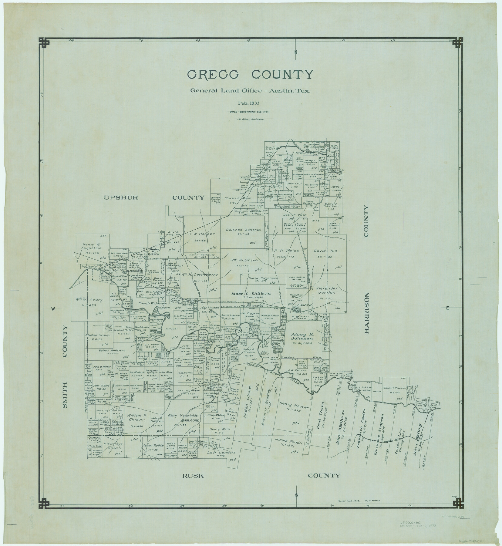
Gregg County
-
Map/Doc
66841
-
Collection
General Map Collection
-
Object Dates
1933 (Creation Date)
-
People and Organizations
Texas General Land Office (Publisher)
J. Bascom Giles (Draftsman)
J. Bascom Giles (Compiler)
-
Counties
Gregg
-
Subjects
County
-
Height x Width
36.1 x 33.2 inches
91.7 x 84.3 cm
-
Comments
Traced June 1, 1933 by W. M. Beck.
Part of: General Map Collection
Kleberg County Rolled Sketch 10-32

Print $20.00
- Digital $50.00
Kleberg County Rolled Sketch 10-32
1952
Size 36.2 x 34.5 inches
Map/Doc 9369
Culberson County Working Sketch 75

Print $40.00
- Digital $50.00
Culberson County Working Sketch 75
1975
Size 48.1 x 32.8 inches
Map/Doc 68529
Andrews County Sketch File 13

Print $12.00
- Digital $50.00
Andrews County Sketch File 13
1979
Size 14.2 x 8.7 inches
Map/Doc 12863
Starr County Rolled Sketch 38

Print $40.00
- Digital $50.00
Starr County Rolled Sketch 38
1944
Size 97.9 x 25.0 inches
Map/Doc 10297
Panola County Working Sketch 36

Print $40.00
- Digital $50.00
Panola County Working Sketch 36
1984
Map/Doc 71445
Aransas County Sketch File 21

Print $2.00
- Digital $50.00
Aransas County Sketch File 21
Size 8.0 x 8.9 inches
Map/Doc 13157
Cameron County Rolled Sketch 33

Print $20.00
- Digital $50.00
Cameron County Rolled Sketch 33
1996
Size 40.2 x 21.9 inches
Map/Doc 5396
Hall County Sketch File 6

Print $20.00
- Digital $50.00
Hall County Sketch File 6
1885
Size 28.2 x 37.9 inches
Map/Doc 10473
Brewster County Rolled Sketch 27

Print $40.00
- Digital $50.00
Brewster County Rolled Sketch 27
Size 35.1 x 48.8 inches
Map/Doc 8474
Taylor County Rolled Sketch 30

Print $20.00
- Digital $50.00
Taylor County Rolled Sketch 30
1999
Size 29.7 x 29.7 inches
Map/Doc 7923
Briscoe County Sketch File 13

Print $168.00
- Digital $50.00
Briscoe County Sketch File 13
1982
Size 11.2 x 8.7 inches
Map/Doc 16428
Nautical Chart 152-SC - Galveston Bay, Texas

Print $20.00
- Digital $50.00
Nautical Chart 152-SC - Galveston Bay, Texas
1972
Size 15.4 x 18.5 inches
Map/Doc 75908
You may also like
Castro County Sketch File 5a

Print $8.00
- Digital $50.00
Castro County Sketch File 5a
1904
Size 11.2 x 8.7 inches
Map/Doc 17491
Flight Mission No. CRC-3R, Frame 211, Chambers County

Print $20.00
- Digital $50.00
Flight Mission No. CRC-3R, Frame 211, Chambers County
1956
Size 18.6 x 22.2 inches
Map/Doc 84866
Gray County Sketch File 7c

Print $20.00
- Digital $50.00
Gray County Sketch File 7c
1885
Size 26.5 x 19.6 inches
Map/Doc 11576
Wise County Sketch File 39

Print $4.00
- Digital $50.00
Wise County Sketch File 39
1860
Size 9.3 x 8.1 inches
Map/Doc 40595
Navigation Maps of Gulf Intracoastal Waterway, Port Arthur to Brownsville, Texas

Print $4.00
- Digital $50.00
Navigation Maps of Gulf Intracoastal Waterway, Port Arthur to Brownsville, Texas
1951
Size 16.6 x 21.3 inches
Map/Doc 65431
Lipscomb County Boundary File 1

Print $16.00
- Digital $50.00
Lipscomb County Boundary File 1
Size 9.0 x 8.0 inches
Map/Doc 56307
Kinney County Sketch File E1

Print $20.00
- Digital $50.00
Kinney County Sketch File E1
1885
Size 29.8 x 31.9 inches
Map/Doc 10619
[Leagues 464-467 and vicinity]
![91649, [Leagues 464-467 and vicinity], Twichell Survey Records](https://historictexasmaps.com/wmedia_w700/maps/91649-1.tif.jpg)
Print $2.00
- Digital $50.00
[Leagues 464-467 and vicinity]
Size 10.6 x 8.1 inches
Map/Doc 91649
Flight Mission No. CRE-2R, Frame 168, Jackson County

Print $20.00
- Digital $50.00
Flight Mission No. CRE-2R, Frame 168, Jackson County
1956
Size 18.5 x 22.3 inches
Map/Doc 85378

Flight Mission No. BRA-16M, Frame 127, Jefferson County

Print $20.00
- Digital $50.00
Flight Mission No. BRA-16M, Frame 127, Jefferson County
1953
Size 18.6 x 22.6 inches
Map/Doc 85737
Rains County Working Sketch 7

Print $20.00
- Digital $50.00
Rains County Working Sketch 7
1964
Size 32.6 x 38.6 inches
Map/Doc 71833