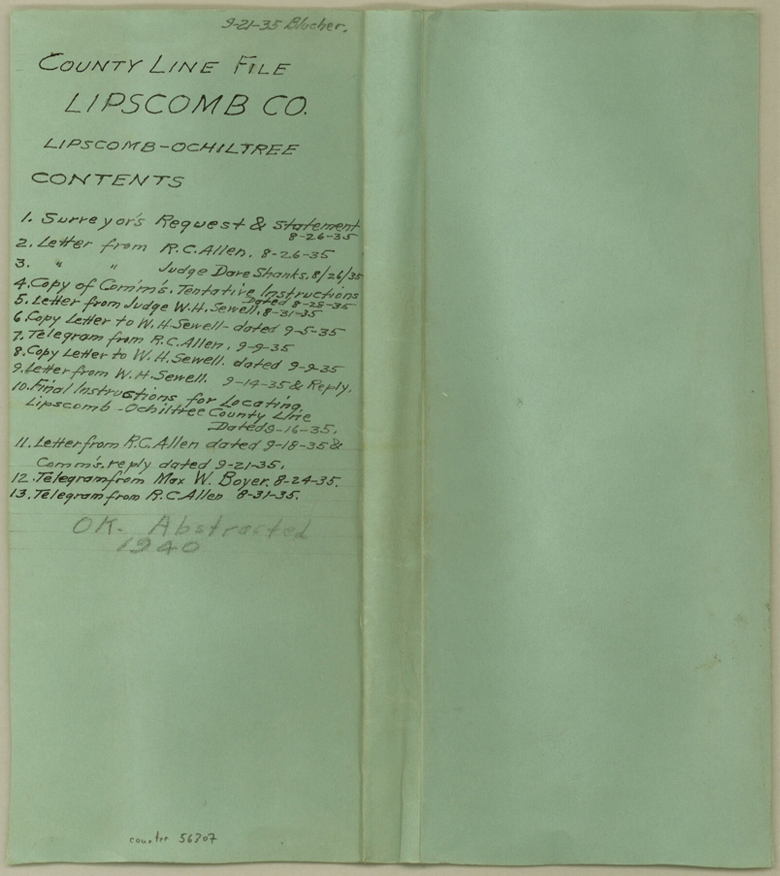
Lipscomb County Boundary File 1
Lipscomb-Ochiltree statement by E. H. Ervin, Surveyor for Lipscomb Co.
-
Map/Doc
56307
-
Collection
General Map Collection
-
Counties
Lipscomb
-
Subjects
County Boundaries
-
Height x Width
9.0 x 8.0 inches
22.9 x 20.3 cm
Part of: General Map Collection
Map of the Central and Montgomery Railroad

Print $20.00
- Digital $50.00
Map of the Central and Montgomery Railroad
1881
Size 12.6 x 36.8 inches
Map/Doc 64141
El Paso County Sketch File 35 (5)

Print $6.00
- Digital $50.00
El Paso County Sketch File 35 (5)
1886
Size 14.6 x 8.9 inches
Map/Doc 22218
Fisher County Boundary File 3

Print $32.00
- Digital $50.00
Fisher County Boundary File 3
Size 8.2 x 4.2 inches
Map/Doc 53428
Bosque County Working Sketch 8

Print $20.00
- Digital $50.00
Bosque County Working Sketch 8
1942
Size 23.1 x 33.4 inches
Map/Doc 67441
Cameron County Rolled Sketch 7A

Print $20.00
- Digital $50.00
Cameron County Rolled Sketch 7A
1926
Size 30.2 x 34.0 inches
Map/Doc 5384
Burnet County Boundary File 6

Print $14.00
- Digital $50.00
Burnet County Boundary File 6
Size 14.1 x 8.6 inches
Map/Doc 50886
Zavala County Sketch File 15a

Print $6.00
- Digital $50.00
Zavala County Sketch File 15a
1886
Size 14.4 x 9.0 inches
Map/Doc 41321
Jim Hogg County Sketch File 8

Print $20.00
- Digital $50.00
Jim Hogg County Sketch File 8
1941
Size 21.9 x 27.0 inches
Map/Doc 11887
Flight Mission No. BRA-7M, Frame 130, Jefferson County

Print $20.00
- Digital $50.00
Flight Mission No. BRA-7M, Frame 130, Jefferson County
1953
Size 16.2 x 16.0 inches
Map/Doc 85524
Brazos River, Harlem-Imperial Farms Project

Print $4.00
- Digital $50.00
Brazos River, Harlem-Imperial Farms Project
1931
Size 29.4 x 26.6 inches
Map/Doc 65285
Navarro County Working Sketch 6

Print $20.00
- Digital $50.00
Navarro County Working Sketch 6
1950
Size 25.3 x 33.7 inches
Map/Doc 71236
Deaf Smith County Working Sketch Graphic Index

Print $40.00
- Digital $50.00
Deaf Smith County Working Sketch Graphic Index
1926
Size 40.1 x 52.6 inches
Map/Doc 76519
You may also like
Chambers County Working Sketch 13

Print $20.00
- Digital $50.00
Chambers County Working Sketch 13
1956
Size 30.1 x 24.6 inches
Map/Doc 67996
[Surveys in the Jefferson District]
![275, [Surveys in the Jefferson District], General Map Collection](https://historictexasmaps.com/wmedia_w700/maps/275.tif.jpg)
Print $2.00
- Digital $50.00
[Surveys in the Jefferson District]
1841
Size 8.3 x 8.0 inches
Map/Doc 275
Culberson County Rolled Sketch 43A

Print $20.00
- Digital $50.00
Culberson County Rolled Sketch 43A
1947
Size 21.7 x 37.2 inches
Map/Doc 5665
St. Louis, Brownsville & Mexico Railway Location Map from Mile 80 to Mile 100

Print $40.00
- Digital $50.00
St. Louis, Brownsville & Mexico Railway Location Map from Mile 80 to Mile 100
1905
Size 19.5 x 64.6 inches
Map/Doc 64166
Angelina County Sketch File 21a

Print $24.00
- Digital $50.00
Angelina County Sketch File 21a
1883
Size 8.3 x 12.6 inches
Map/Doc 13041
[Anderson County]
![5051, [Anderson County], General Map Collection](https://historictexasmaps.com/wmedia_w700/maps/5051-GC.tif.jpg)
Print $20.00
- Digital $50.00
[Anderson County]
1848
Size 26.0 x 19.9 inches
Map/Doc 5051
Brazoria County Rolled Sketch CL

Print $20.00
- Digital $50.00
Brazoria County Rolled Sketch CL
1934
Size 22.0 x 32.8 inches
Map/Doc 8463
Hamilton County Working Sketch 26

Print $20.00
- Digital $50.00
Hamilton County Working Sketch 26
1964
Size 22.8 x 29.6 inches
Map/Doc 63364
Montgomery County Working Sketch 19

Print $20.00
- Digital $50.00
Montgomery County Working Sketch 19
1935
Size 31.8 x 36.6 inches
Map/Doc 71126
Mason County Sketch File 2

Print $22.00
- Digital $50.00
Mason County Sketch File 2
1847
Size 8.0 x 14.2 inches
Map/Doc 30680
Walker County Miscellaneous Sketch 1

Print $20.00
- Digital $50.00
Walker County Miscellaneous Sketch 1
2003
Size 36.0 x 31.3 inches
Map/Doc 88868
Flight Mission No. DQO-12K, Frame 42, Galveston County

Print $20.00
- Digital $50.00
Flight Mission No. DQO-12K, Frame 42, Galveston County
1952
Size 18.6 x 22.3 inches
Map/Doc 85232