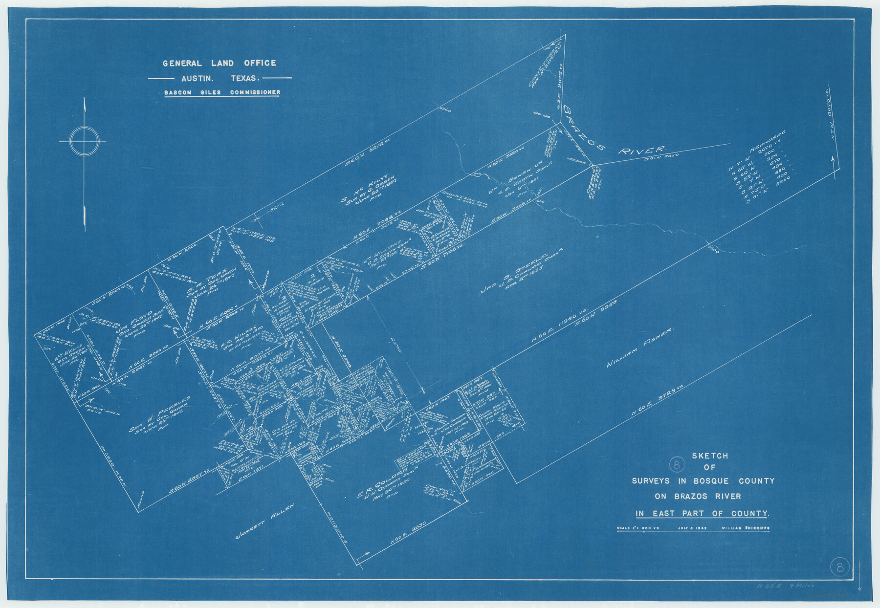
Bosque County Working Sketch 8
-
Map/Doc
67441
-
Collection
General Map Collection
-
Object Dates
7/8/1942 (Creation Date)
-
People and Organizations
Bascom Giles (GLO Commissioner)
William Shirriffs (Draftsman)
-
Counties
Bosque
-
Subjects
Surveying Working Sketch
-
Height x Width
23.1 x 33.4 inches
58.7 x 84.8 cm
-
Scale
1" = 600 varas
-
Comments
Surveys located about nine miles North 65 degrees East of Meridian, Texas.
Part of: General Map Collection
Galveston County Rolled Sketch 30

Print $20.00
- Digital $50.00
Galveston County Rolled Sketch 30
1979
Size 28.0 x 39.8 inches
Map/Doc 5964
Brazoria County Working Sketch 7

Print $20.00
- Digital $50.00
Brazoria County Working Sketch 7
1930
Size 40.9 x 21.1 inches
Map/Doc 67492
Fifteenth Census 1930 Population - Texas

Print $20.00
- Digital $50.00
Fifteenth Census 1930 Population - Texas
1930
Size 19.5 x 22.6 inches
Map/Doc 2146
Reagan County Working Sketch 35

Print $40.00
- Digital $50.00
Reagan County Working Sketch 35
1966
Size 29.7 x 51.4 inches
Map/Doc 71877
Map of Baffin & Alazan Bays, Cayo Infiernillo in Kenedy & Kleberg Counties Showing Subdivision for Mineral Development

Print $20.00
- Digital $50.00
Map of Baffin & Alazan Bays, Cayo Infiernillo in Kenedy & Kleberg Counties Showing Subdivision for Mineral Development
1937
Size 42.4 x 40.4 inches
Map/Doc 3016
Map of Austin's Little Colony

Print $20.00
- Digital $50.00
Map of Austin's Little Colony
Size 19.0 x 23.3 inches
Map/Doc 76007
Sterling County Sketch File 11

Print $40.00
- Digital $50.00
Sterling County Sketch File 11
1929
Size 14.2 x 17.2 inches
Map/Doc 37148
Marion County Working Sketch 27

Print $20.00
- Digital $50.00
Marion County Working Sketch 27
1971
Size 44.8 x 41.0 inches
Map/Doc 70803
San Jacinto County Rolled Sketch 13

Print $20.00
- Digital $50.00
San Jacinto County Rolled Sketch 13
1994
Size 32.2 x 23.7 inches
Map/Doc 7562
Newton County Working Sketch 26

Print $20.00
- Digital $50.00
Newton County Working Sketch 26
1953
Size 18.3 x 16.4 inches
Map/Doc 71272
Cottle County Working Sketch 18

Print $20.00
- Digital $50.00
Cottle County Working Sketch 18
1977
Size 32.2 x 41.3 inches
Map/Doc 68328
Working Sketch of surveys in Brazoria County, showing Cedar Lakes

Print $40.00
- Digital $50.00
Working Sketch of surveys in Brazoria County, showing Cedar Lakes
1950
Size 31.2 x 57.3 inches
Map/Doc 1932
You may also like
![4828, [San Diego], General Map Collection](https://historictexasmaps.com/wmedia_w700/maps/4828-1.tif.jpg)
Runnels County Rolled Sketch 30

Print $20.00
- Digital $50.00
Runnels County Rolled Sketch 30
Size 26.8 x 30.6 inches
Map/Doc 7518
Childress County Rolled Sketch 9D

Print $3.00
- Digital $50.00
Childress County Rolled Sketch 9D
1945
Size 16.0 x 10.0 inches
Map/Doc 78221
Aransas County NRC Article 33.136 Sketch 9

Print $24.00
- Digital $50.00
Aransas County NRC Article 33.136 Sketch 9
2013
Size 24.0 x 36.0 inches
Map/Doc 94469
[Plat of Survey 1, Block B]
![91448, [Plat of Survey 1, Block B], Twichell Survey Records](https://historictexasmaps.com/wmedia_w700/maps/91448-1.tif.jpg)
Print $3.00
- Digital $50.00
[Plat of Survey 1, Block B]
1907
Size 11.7 x 12.6 inches
Map/Doc 91448
Flight Mission No. DQO-11K, Frame 23, Galveston County

Print $20.00
- Digital $50.00
Flight Mission No. DQO-11K, Frame 23, Galveston County
1952
Size 18.8 x 22.4 inches
Map/Doc 85220
Harris County Rolled Sketch O

Print $20.00
- Digital $50.00
Harris County Rolled Sketch O
Size 19.3 x 28.9 inches
Map/Doc 6141
Flight Mission No. BQR-3K, Frame 156, Brazoria County

Print $20.00
- Digital $50.00
Flight Mission No. BQR-3K, Frame 156, Brazoria County
1952
Size 18.6 x 22.4 inches
Map/Doc 83983
Nueces County Rolled Sketch 36

Print $199.00
- Digital $50.00
Nueces County Rolled Sketch 36
Size 10.7 x 15.2 inches
Map/Doc 47617
Anderson County Working Sketch 24

Print $20.00
- Digital $50.00
Anderson County Working Sketch 24
1917
Size 16.6 x 15.3 inches
Map/Doc 67024
Brewster County Sketch File D

Print $4.00
- Digital $50.00
Brewster County Sketch File D
1938
Size 14.5 x 8.8 inches
Map/Doc 15738
Flight Mission No. CRC-3R, Frame 164, Chambers County

Print $20.00
- Digital $50.00
Flight Mission No. CRC-3R, Frame 164, Chambers County
1956
Size 18.7 x 22.3 inches
Map/Doc 84846