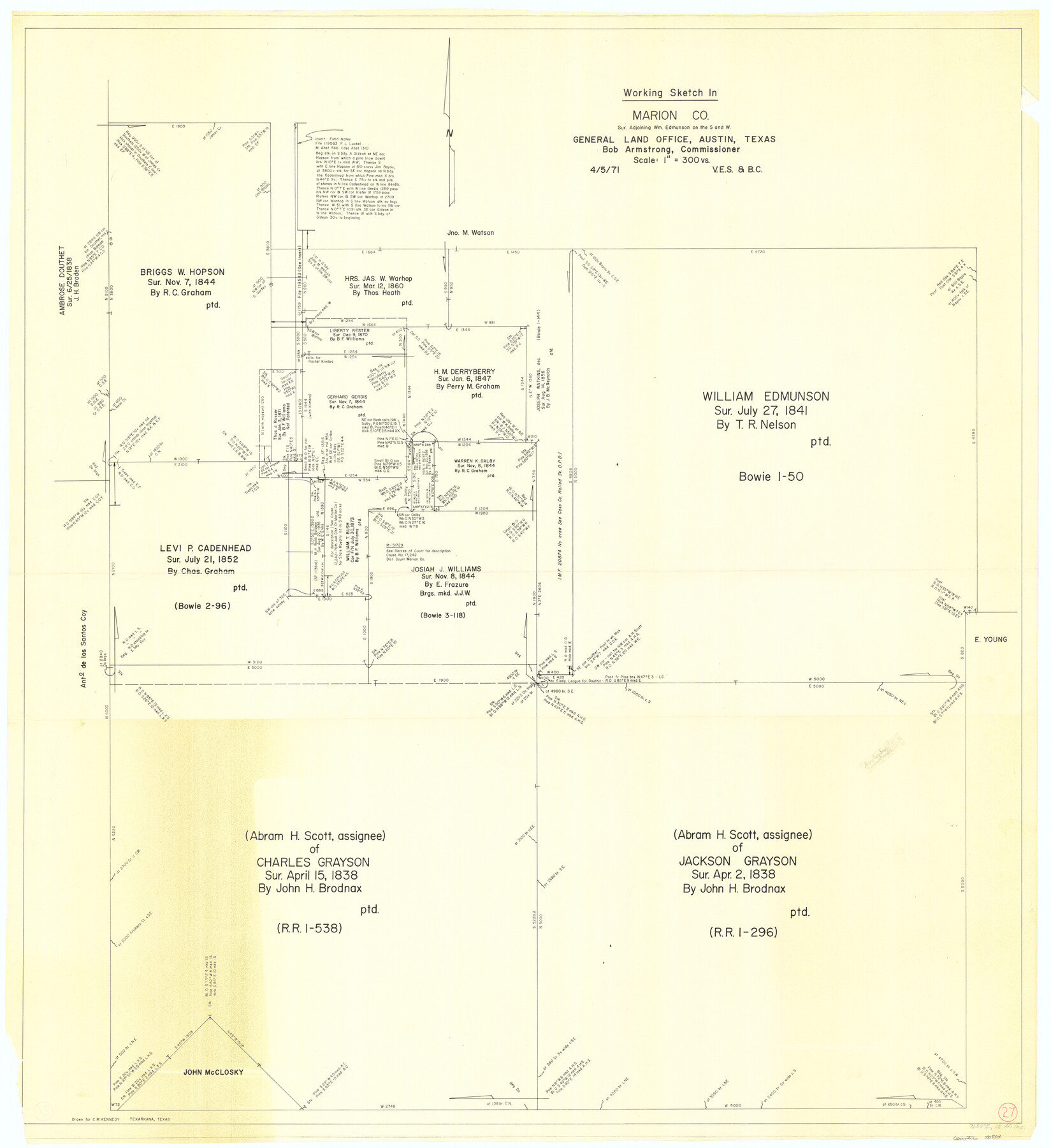
Marion County Working Sketch 27
- 
                          Map/Doc70803
- 
                            CollectionGeneral Map Collection
- 
                            Object Dates4/5/1971 (Creation Date)
- 
                            People and OrganizationsVictor E. Sterzing (Draftsman)Beverly Christian (Draftsman)
- 
                            CountiesMarion
- 
                            SubjectsSurveying Working Sketch
- 
                            Height x Width44.8 x 41.0 inches113.8 x 104.1 cm
- 
                            Scale1" = 300 varas
Part of: General Map Collection
            South Part Presidio County


                                            Print $20.00                    
                                             -                         Digital $50.00                                    
                South Part Presidio County
1975
Size 31.6 x 37.2 inches
                                Map/Doc 77400
            
            San Saba County Working Sketch 14


                                            Print $20.00                    
                                             -                         Digital $50.00                                    
                San Saba County Working Sketch 14
1998
Size 29.0 x 42.8 inches
                                Map/Doc 63802
            
            Grayson County Sketch File 7


                                            Print $40.00                    
                                             -                         Digital $50.00                                    
                Grayson County Sketch File 7
1856
Size 12.3 x 12.1 inches
                                Map/Doc 24470
            
            Culberson County Sketch File 20


                                            Print $57.00                    
                                             -                         Digital $50.00                                    
                Culberson County Sketch File 20
Size 10.2 x 15.6 inches
                                Map/Doc 20205
            
            [Topographical Map showing part of Miller Day Ranch in Southwest Part of Coleman County]
            
                                    ![81515, [Topographical Map showing part of Miller Day Ranch in Southwest Part of Coleman County], General Map Collection](https://historictexasmaps.com/wmedia_w700/maps/81515.tif.jpg) 


    ![81515, [Topographical Map showing part of Miller Day Ranch in Southwest Part of Coleman County], General Map Collection](https://historictexasmaps.com/wmedia_w700/maps/81515.tif.jpg) 
                                
            
                                            Print $3.00                    
                                             -                         Digital $50.00                                    
                [Topographical Map showing part of Miller Day Ranch in Southwest Part of Coleman County]
Size 11.3 x 17.3 inches
                                Map/Doc 81515
            
            Culberson County Rolled Sketch 43A


                                            Print $20.00                    
                                             -                         Digital $50.00                                    
                Culberson County Rolled Sketch 43A
1947
Size 21.7 x 37.2 inches
                                Map/Doc 5665
            
            Hamilton County Working Sketch 20


                                            Print $20.00                    
                                             -                         Digital $50.00                                    
                Hamilton County Working Sketch 20
1953
Size 32.5 x 30.8 inches
                                Map/Doc 63358
            
            Flight Mission No. CUG-3P, Frame 37, Kleberg County


                                            Print $20.00                    
                                             -                         Digital $50.00                                    
                Flight Mission No. CUG-3P, Frame 37, Kleberg County
1956
Size 18.5 x 22.2 inches
                                Map/Doc 86242
            
            Val Verde County Working Sketch 117


                                            Print $20.00                    
                                             -                         Digital $50.00                                    
                Val Verde County Working Sketch 117
1993
Size 30.9 x 37.0 inches
                                Map/Doc 82844
            
            Runnels County Working Sketch 15


                                            Print $20.00                    
                                             -                         Digital $50.00                                    
                Runnels County Working Sketch 15
1950
Size 22.8 x 18.5 inches
                                Map/Doc 63611
            
            Harris County Working Sketch 45


                                            Print $20.00                    
                                             -                         Digital $50.00                                    
                Harris County Working Sketch 45
1942
Size 26.6 x 31.9 inches
                                Map/Doc 65937
            
            Chambers County Boundary File 50a


                                            Print $40.00                    
                                             -                         Digital $50.00                                    
                Chambers County Boundary File 50a
Size 22.2 x 17.1 inches
                                Map/Doc 51270
            You may also like
            Ector County Working Sketch 8


                                            Print $20.00                    
                                             -                         Digital $50.00                                    
                Ector County Working Sketch 8
1944
Size 40.5 x 26.5 inches
                                Map/Doc 68851
            
            Nueces County Sketch File 47


                                            Print $17.00                    
                                             -                         Digital $50.00                                    
                Nueces County Sketch File 47
Size 14.3 x 8.5 inches
                                Map/Doc 32655
            
            Webb County Rolled Sketch 73


                                            Print $20.00                    
                                             -                         Digital $50.00                                    
                Webb County Rolled Sketch 73
1982
Size 33.2 x 17.2 inches
                                Map/Doc 8221
            
            Foard County Sketch File X


                                            Print $20.00                    
                                             -                         Digital $50.00                                    
                Foard County Sketch File X
1882
Size 15.8 x 17.3 inches
                                Map/Doc 11499
            
            Il Texas: La Ferrovia New York Texas-Messicana, La Colonizzazione Italiana della costa del Texas


                                            Print $20.00                    
                                             -                         Digital $50.00                                    
                Il Texas: La Ferrovia New York Texas-Messicana, La Colonizzazione Italiana della costa del Texas
1881
Size 17.6 x 22.0 inches
                                Map/Doc 97406
            
            Rusk County Sketch File 8


                                            Print $4.00                    
                                    
                Rusk County Sketch File 8
1856
Size 12.7 x 8.2 inches
                                Map/Doc 35503
            
            Flight Mission No. BRA-8M, Frame 25, Jefferson County


                                            Print $20.00                    
                                             -                         Digital $50.00                                    
                Flight Mission No. BRA-8M, Frame 25, Jefferson County
1953
Size 18.4 x 22.5 inches
                                Map/Doc 85580
            
            Montague County Working Sketch 30


                                            Print $4.00                    
                                             -                         Digital $50.00                                    
                Montague County Working Sketch 30
1974
Size 22.7 x 23.3 inches
                                Map/Doc 71096
            
            Connected Map of Austin's Colony (1892 tracing)


                                            Print $40.00                    
                                             -                         Digital $50.00                                    
                Connected Map of Austin's Colony (1892 tracing)
1837
Size 90.8 x 46.7 inches
                                Map/Doc 93358
            
            [Sketch highlighting Bob Reid and Fred Turner surveys]
            
                                    ![91692, [Sketch highlighting Bob Reid and Fred Turner surveys], Twichell Survey Records](https://historictexasmaps.com/wmedia_w700/maps/91692-1.tif.jpg) 


    ![91692, [Sketch highlighting Bob Reid and Fred Turner surveys], Twichell Survey Records](https://historictexasmaps.com/wmedia_w700/maps/91692-1.tif.jpg) 
                                
            
                                            Print $2.00                    
                                             -                         Digital $50.00                                    
                [Sketch highlighting Bob Reid and Fred Turner surveys]
Size 5.9 x 7.6 inches
                                Map/Doc 91692
            
            La Salle County Working Sketch 48


                                            Print $20.00                    
                                             -                         Digital $50.00                                    
                La Salle County Working Sketch 48
1983
Size 26.2 x 36.0 inches
                                Map/Doc 70349
             
                        