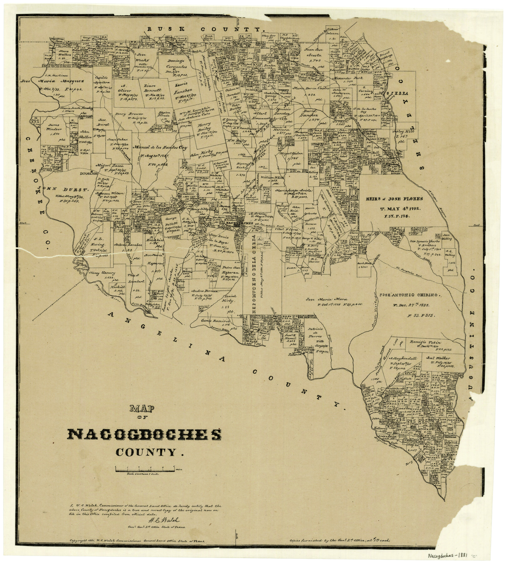
Map of Nacogdoches County
-
Map/Doc
4606
-
Collection
General Map Collection
-
Object Dates
1881 (Creation Date)
-
People and Organizations
Texas General Land Office (Publisher)
W.C. Walsh (GLO Commissioner)
G.N. Beaumont (Compiler)
G.N. Beaumont (Draftsman)
August Gast & Co. (Lithographer)
-
Counties
Nacogdoches
-
Subjects
County
-
Height x Width
24.3 x 21.9 inches
61.7 x 55.6 cm
-
Features
Lamana Bayou
Little Loco Creek
Alazon Bayou
Bayou Morell
Carozo Bayou
Melrose
Arroya Amaladero
Old Nacogdoches Road
Arrollo Visitador
Dorr Creek
Rota Creek
Angelina River
Loco Bayou
Patonia
La Vaca Creek
Durazno Bayou
Sandy Creek
Nacogdoches
Bayou Carizo
Raiz Creek
Douglass
Agillitas Creek
Bills Creek
Pen Creek
Beeck Creek
Wandes Bayou
Colondrina Bayou
Aycilas Crossing
Arroya Nasosote
Naconiche Bayou
Loco Creek
Bolija Creek
Cany Creek
Attoyac Bayou
Shelbyville Road
Red Creek
White Oak Creek
Old San Antonio Road
Part of: General Map Collection
United States Atlantic and Gulf Coasts Including Puerto Rico and the Virgin Islands

Print $40.00
- Digital $50.00
United States Atlantic and Gulf Coasts Including Puerto Rico and the Virgin Islands
1973
Size 21.5 x 60.4 inches
Map/Doc 76126
Flight Mission No. CUG-3P, Frame 36, Kleberg County

Print $20.00
- Digital $50.00
Flight Mission No. CUG-3P, Frame 36, Kleberg County
1956
Size 18.4 x 22.1 inches
Map/Doc 86241
Dickens County Sketch File H3

Print $10.00
- Digital $50.00
Dickens County Sketch File H3
1904
Size 10.9 x 8.5 inches
Map/Doc 20876
Fisher County Rolled Sketch 6

Print $20.00
- Digital $50.00
Fisher County Rolled Sketch 6
1971
Size 26.9 x 26.7 inches
Map/Doc 5877
Lampasas County Sketch File 9a

Print $4.00
- Digital $50.00
Lampasas County Sketch File 9a
1872
Size 12.8 x 8.0 inches
Map/Doc 29410
Texas-Oklahoma, Red River, Big Bend Area

Print $40.00
- Digital $50.00
Texas-Oklahoma, Red River, Big Bend Area
1921
Size 23.3 x 57.6 inches
Map/Doc 75251
Harris County Sketch File 88

Print $171.00
- Digital $50.00
Harris County Sketch File 88
1914
Size 13.8 x 12.1 inches
Map/Doc 25555
Jeff Davis County Sketch File 39

Print $10.00
- Digital $50.00
Jeff Davis County Sketch File 39
Size 14.2 x 8.7 inches
Map/Doc 28057
Flight Mission No. DQN-1K, Frame 45, Calhoun County

Print $20.00
- Digital $50.00
Flight Mission No. DQN-1K, Frame 45, Calhoun County
1953
Size 15.8 x 15.6 inches
Map/Doc 84145
Texas-Oklahoma Boundary Line: brief summary of the lands surveyed and the lands not surveyed in the dispute between Oklahoma vs. Texas

Print $356.00
- Digital $50.00
Texas-Oklahoma Boundary Line: brief summary of the lands surveyed and the lands not surveyed in the dispute between Oklahoma vs. Texas
1923
Size 6.0 x 9.2 inches
Map/Doc 3061
Flight Mission No. DCL-5C, Frame 3, Kenedy County

Print $20.00
- Digital $50.00
Flight Mission No. DCL-5C, Frame 3, Kenedy County
1943
Size 18.4 x 22.2 inches
Map/Doc 85828
Crosby County Sketch File 35

Print $4.00
- Digital $50.00
Crosby County Sketch File 35
Size 8.5 x 12.1 inches
Map/Doc 20106
You may also like
Culberson County Sketch [showing PSL Blocks 109-111, 113-115 and University Block 46]
![90500, Culberson County Sketch [showing PSL Blocks 109-111, 113-115 and University Block 46], Twichell Survey Records](https://historictexasmaps.com/wmedia_w700/maps/90500-1.tif.jpg)
Print $20.00
- Digital $50.00
Culberson County Sketch [showing PSL Blocks 109-111, 113-115 and University Block 46]
Size 25.8 x 12.7 inches
Map/Doc 90500
Flight Mission No. DCL-7C, Frame 76, Kenedy County

Print $20.00
- Digital $50.00
Flight Mission No. DCL-7C, Frame 76, Kenedy County
1943
Size 15.4 x 15.1 inches
Map/Doc 86062
Briscoe County Sketch File A

Print $40.00
- Digital $50.00
Briscoe County Sketch File A
1894
Size 17.3 x 21.1 inches
Map/Doc 10997
Harris County Historic Topographic 10

Print $20.00
- Digital $50.00
Harris County Historic Topographic 10
1916
Size 30.2 x 22.9 inches
Map/Doc 65820
Motley County Sketch File 14 (N)

Print $8.00
- Digital $50.00
Motley County Sketch File 14 (N)
Size 13.6 x 8.7 inches
Map/Doc 32048
Flight Mission No. BRA-7M, Frame 76, Jefferson County

Print $20.00
- Digital $50.00
Flight Mission No. BRA-7M, Frame 76, Jefferson County
1953
Size 18.8 x 22.3 inches
Map/Doc 85498
Brewster County Sketch File NS-8

Print $311.00
- Digital $50.00
Brewster County Sketch File NS-8
Size 15.0 x 9.1 inches
Map/Doc 15999
Callahan County Sketch File 2

Print $8.00
- Digital $50.00
Callahan County Sketch File 2
1858
Size 11.8 x 8.7 inches
Map/Doc 35853
Aransas County Sketch File 34

Print $54.00
- Digital $50.00
Aransas County Sketch File 34
1919
Size 14.3 x 8.5 inches
Map/Doc 13320
Flight Mission No. CUG-1P, Frame 170, Kleberg County

Print $20.00
- Digital $50.00
Flight Mission No. CUG-1P, Frame 170, Kleberg County
1956
Size 18.5 x 22.2 inches
Map/Doc 86177
Flight Mission No. DQN-7K, Frame 89, Calhoun County

Print $20.00
- Digital $50.00
Flight Mission No. DQN-7K, Frame 89, Calhoun County
1953
Size 18.4 x 22.2 inches
Map/Doc 84480
Johnson County Working Sketch 19

Print $20.00
- Digital $50.00
Johnson County Working Sketch 19
1990
Size 35.2 x 42.5 inches
Map/Doc 66632