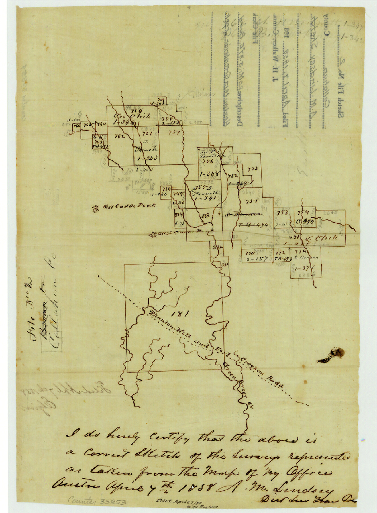
Callahan County Sketch File 2
[Sketch of surveys near headwaters of Greenbriar Creek]
-
Map/Doc
35853
-
Collection
General Map Collection
-
Object Dates
1858/4/7 (Creation Date)
1858/4/7 (File Date)
-
People and Organizations
A.M. Lindsey (Surveyor/Engineer)
-
Counties
Eastland Coleman Callahan
-
Subjects
Surveying Sketch File
-
Height x Width
11.8 x 8.7 inches
30.0 x 22.1 cm
-
Medium
paper, manuscript
-
Features
West Caddo Peak
Phantom Hill and Fort Croghan Road
Phantom Hill Road
Fort Croghan Road
Green Brier [sic] Creek
[Pecan Bayou]
Part of: General Map Collection
Webb County Working Sketch 63

Print $20.00
- Digital $50.00
Webb County Working Sketch 63
1962
Size 11.1 x 24.2 inches
Map/Doc 72429
Plat of a survey on Padre Island in Willacy and Kenedy Counties surveyed for South Padre Development Corporation by Claunch and Associates

Print $20.00
- Digital $50.00
Plat of a survey on Padre Island in Willacy and Kenedy Counties surveyed for South Padre Development Corporation by Claunch and Associates
1973
Size 46.5 x 41.6 inches
Map/Doc 61424
Red River County Working Sketch 30

Print $20.00
- Digital $50.00
Red River County Working Sketch 30
1962
Size 25.2 x 22.8 inches
Map/Doc 72013
Flight Mission No. DQO-7K, Frame 113, Galveston County

Print $20.00
- Digital $50.00
Flight Mission No. DQO-7K, Frame 113, Galveston County
1952
Size 18.7 x 22.3 inches
Map/Doc 85128
Titus County Sketch File 14

Print $4.00
- Digital $50.00
Titus County Sketch File 14
Size 9.7 x 8.3 inches
Map/Doc 38157
Chambers County Rolled Sketch 21

Print $20.00
- Digital $50.00
Chambers County Rolled Sketch 21
1940
Size 42.2 x 44.9 inches
Map/Doc 8590
Right of Way and Track Map, International & Gt. Northern Ry. Operated by the International & Gt. Northern Ry. Co., Gulf Division

Print $40.00
- Digital $50.00
Right of Way and Track Map, International & Gt. Northern Ry. Operated by the International & Gt. Northern Ry. Co., Gulf Division
1917
Size 24.8 x 57.0 inches
Map/Doc 64245
Intracoastal Waterway in Texas - Corpus Christi to Point Isabel including Arroyo Colorado to Mo. Pac. R.R. Bridge Near Harlingen

Print $20.00
- Digital $50.00
Intracoastal Waterway in Texas - Corpus Christi to Point Isabel including Arroyo Colorado to Mo. Pac. R.R. Bridge Near Harlingen
1933
Size 27.9 x 40.8 inches
Map/Doc 61878
Flight Mission No. DCL-7C, Frame 28, Kenedy County

Print $20.00
- Digital $50.00
Flight Mission No. DCL-7C, Frame 28, Kenedy County
1943
Size 15.4 x 15.4 inches
Map/Doc 86020
Chambers County Sketch File 58

Print $2.00
- Digital $50.00
Chambers County Sketch File 58
1995
Size 9.1 x 14.7 inches
Map/Doc 18108
Flight Mission No. CGI-2N, Frame 152, Cameron County

Print $20.00
- Digital $50.00
Flight Mission No. CGI-2N, Frame 152, Cameron County
1954
Size 18.7 x 22.1 inches
Map/Doc 84534
Dimmit County Working Sketch 8

Print $20.00
- Digital $50.00
Dimmit County Working Sketch 8
1930
Size 35.8 x 29.9 inches
Map/Doc 68669
You may also like
Orange County Sketch File 41

Print $40.00
- Digital $50.00
Orange County Sketch File 41
1918
Size 13.2 x 13.3 inches
Map/Doc 33381
Laguna Madre from Rainy Triangulation Station to Mosquito Triangulation Station

Print $40.00
- Digital $50.00
Laguna Madre from Rainy Triangulation Station to Mosquito Triangulation Station
1881
Size 31.4 x 53.7 inches
Map/Doc 73490
Burnet County Highway Map

Print $20.00
- Digital $50.00
Burnet County Highway Map
Size 25.5 x 18.5 inches
Map/Doc 92471
Typus Orbis Terrarum

Print $20.00
- Digital $50.00
Typus Orbis Terrarum
1575
Size 15.2 x 20.8 inches
Map/Doc 96579
Leon County Working Sketch 4

Print $20.00
- Digital $50.00
Leon County Working Sketch 4
Size 18.1 x 14.0 inches
Map/Doc 70403
Freestone County Working Sketch 7

Print $20.00
- Digital $50.00
Freestone County Working Sketch 7
1951
Size 32.8 x 24.4 inches
Map/Doc 69249
Young County Working Sketch 8

Print $20.00
- Digital $50.00
Young County Working Sketch 8
1920
Size 17.3 x 12.6 inches
Map/Doc 62031
Brewster County Sketch File NS-5

Print $22.00
- Digital $50.00
Brewster County Sketch File NS-5
Size 11.2 x 8.8 inches
Map/Doc 15983
Ellis County Boundary File 3b

Print $14.00
- Digital $50.00
Ellis County Boundary File 3b
Size 11.2 x 8.7 inches
Map/Doc 52965
Baffin and Alazan Bays, Cayo Infiernillo in Kenedy and Kleberg Counties, showing Subdivision for Mineral Development

Print $40.00
- Digital $50.00
Baffin and Alazan Bays, Cayo Infiernillo in Kenedy and Kleberg Counties, showing Subdivision for Mineral Development
1949
Size 33.0 x 52.4 inches
Map/Doc 1923
Map of Texas in 1836

Print $20.00
- Digital $50.00
Map of Texas in 1836
1936
Size 24.5 x 19.3 inches
Map/Doc 449
Galveston County NRC Article 33.136 Sketch 76

Print $26.00
- Digital $50.00
Galveston County NRC Article 33.136 Sketch 76
2014
Size 24.5 x 36.5 inches
Map/Doc 95125