Chambers County Rolled Sketch 21
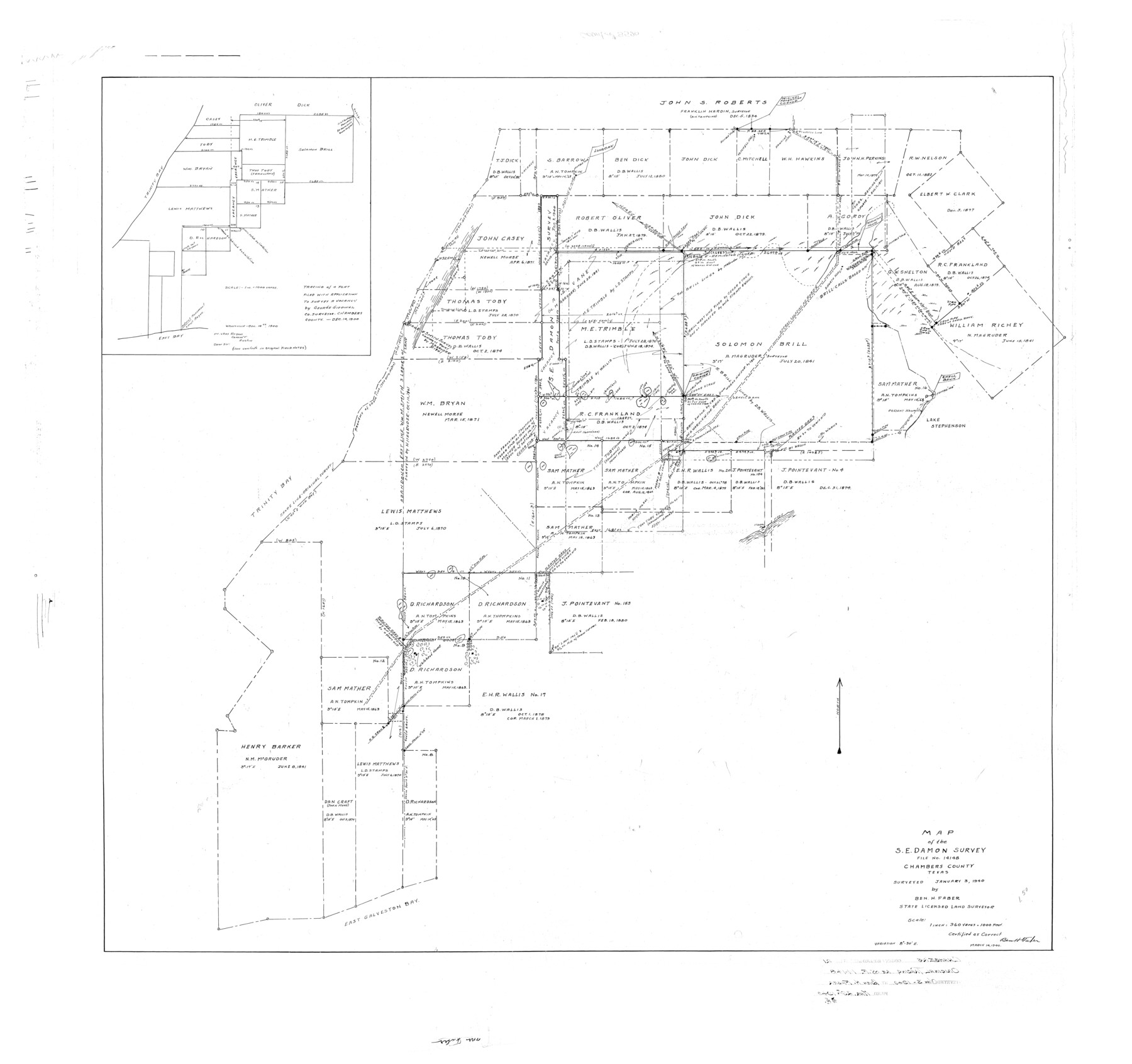
Map of the S.E. Damon survey file no. 14148 Chambers County, Texas
-
Map/Doc
8590
-
Collection
General Map Collection
-
Object Dates
1940/1/3 (Survey Date)
1940/3/25 (File Date)
1940/3/14 (Creation Date)
-
People and Organizations
Ben H. Faber (Surveyor/Engineer)
-
Counties
Chambers
-
Subjects
Surveying Rolled Sketch
-
Height x Width
42.2 x 44.9 inches
107.2 x 114.0 cm
-
Scale
1" = 360 varas = 1000 ft.
Part of: General Map Collection
Bexar County Sketch File 43

Print $4.00
- Digital $50.00
Bexar County Sketch File 43
1882
Size 8.7 x 10.2 inches
Map/Doc 14522
Map of Galveston Bay from Lawrence Cove to Stevenson's Station

Print $20.00
- Digital $50.00
Map of Galveston Bay from Lawrence Cove to Stevenson's Station
1851
Size 41.5 x 30.0 inches
Map/Doc 69922
Menard County Sketch File 11

Print $8.00
- Digital $50.00
Menard County Sketch File 11
1892
Size 12.8 x 8.3 inches
Map/Doc 31496
Flight Mission No. DCL-6C, Frame 92, Kenedy County

Print $20.00
- Digital $50.00
Flight Mission No. DCL-6C, Frame 92, Kenedy County
1943
Size 18.4 x 22.3 inches
Map/Doc 85922
Township 12 South Range 13 West, South Western District, Louisiana

Print $20.00
- Digital $50.00
Township 12 South Range 13 West, South Western District, Louisiana
1838
Size 19.5 x 24.7 inches
Map/Doc 65855
Harrison County Sketch File 15

Print $20.00
- Digital $50.00
Harrison County Sketch File 15
Size 23.2 x 23.0 inches
Map/Doc 11690
Jasper County Rolled Sketch 1

Print $20.00
- Digital $50.00
Jasper County Rolled Sketch 1
Size 11.1 x 18.0 inches
Map/Doc 6347
Dickens County Sketch File 16

Print $4.00
- Digital $50.00
Dickens County Sketch File 16
Size 7.4 x 11.1 inches
Map/Doc 20975
Brown County Working Sketch 12

Print $20.00
- Digital $50.00
Brown County Working Sketch 12
1984
Size 27.0 x 25.2 inches
Map/Doc 67777
Nueces County Rolled Sketch 75

Print $40.00
- Digital $50.00
Nueces County Rolled Sketch 75
1945
Size 56.0 x 24.0 inches
Map/Doc 9618

Navarro County Sketch File 17

Print $4.00
- Digital $50.00
Navarro County Sketch File 17
Size 12.8 x 8.4 inches
Map/Doc 32333
You may also like
Flight Mission No. DQN-2K, Frame 76, Calhoun County

Print $20.00
- Digital $50.00
Flight Mission No. DQN-2K, Frame 76, Calhoun County
1953
Size 18.8 x 22.3 inches
Map/Doc 84268
Sutton County Rolled Sketch 71

Print $20.00
- Digital $50.00
Sutton County Rolled Sketch 71
Size 23.1 x 35.3 inches
Map/Doc 83760
Garza County Rolled Sketch 11 & 11A

Print $31.00
- Digital $50.00
Garza County Rolled Sketch 11 & 11A
1915
Size 10.3 x 15.5 inches
Map/Doc 45214
Pecos County Working Sketch 23

Print $20.00
- Digital $50.00
Pecos County Working Sketch 23
1927
Size 45.6 x 40.6 inches
Map/Doc 71494
Flight Mission No. DQN-2K, Frame 116, Calhoun County

Print $20.00
- Digital $50.00
Flight Mission No. DQN-2K, Frame 116, Calhoun County
1953
Size 18.6 x 22.3 inches
Map/Doc 84292
Taylor County Sketch File 20

Print $20.00
- Digital $50.00
Taylor County Sketch File 20
1950
Size 32.1 x 46.1 inches
Map/Doc 10385
[Surveys in Austin's Colony along Chocolate Bayou and Austin Bayou]
![192, [Surveys in Austin's Colony along Chocolate Bayou and Austin Bayou], General Map Collection](https://historictexasmaps.com/wmedia_w700/maps/192.tif.jpg)
Print $20.00
- Digital $50.00
[Surveys in Austin's Colony along Chocolate Bayou and Austin Bayou]
1830
Size 32.9 x 10.8 inches
Map/Doc 192
Guadalupe County Rolled Sketch 1

Print $20.00
- Digital $50.00
Guadalupe County Rolled Sketch 1
1954
Size 33.1 x 38.8 inches
Map/Doc 6044
Journal of the Joint Commission

Print $35.00
- Digital $50.00
Journal of the Joint Commission
1838
Size 9.3 x 6.1 inches
Map/Doc 65515
Marion County Working Sketch 4

Print $20.00
- Digital $50.00
Marion County Working Sketch 4
Size 15.7 x 19.1 inches
Map/Doc 70779
From Citizens of Nacogdoches County for the Creation of a New Judicial County (Unnamed), November 16, 1840

Print $20.00
From Citizens of Nacogdoches County for the Creation of a New Judicial County (Unnamed), November 16, 1840
2020
Size 14.6 x 21.7 inches
Map/Doc 96409
Calhoun County Boundary File 2

Print $50.00
- Digital $50.00
Calhoun County Boundary File 2
Size 9.1 x 7.7 inches
Map/Doc 50968