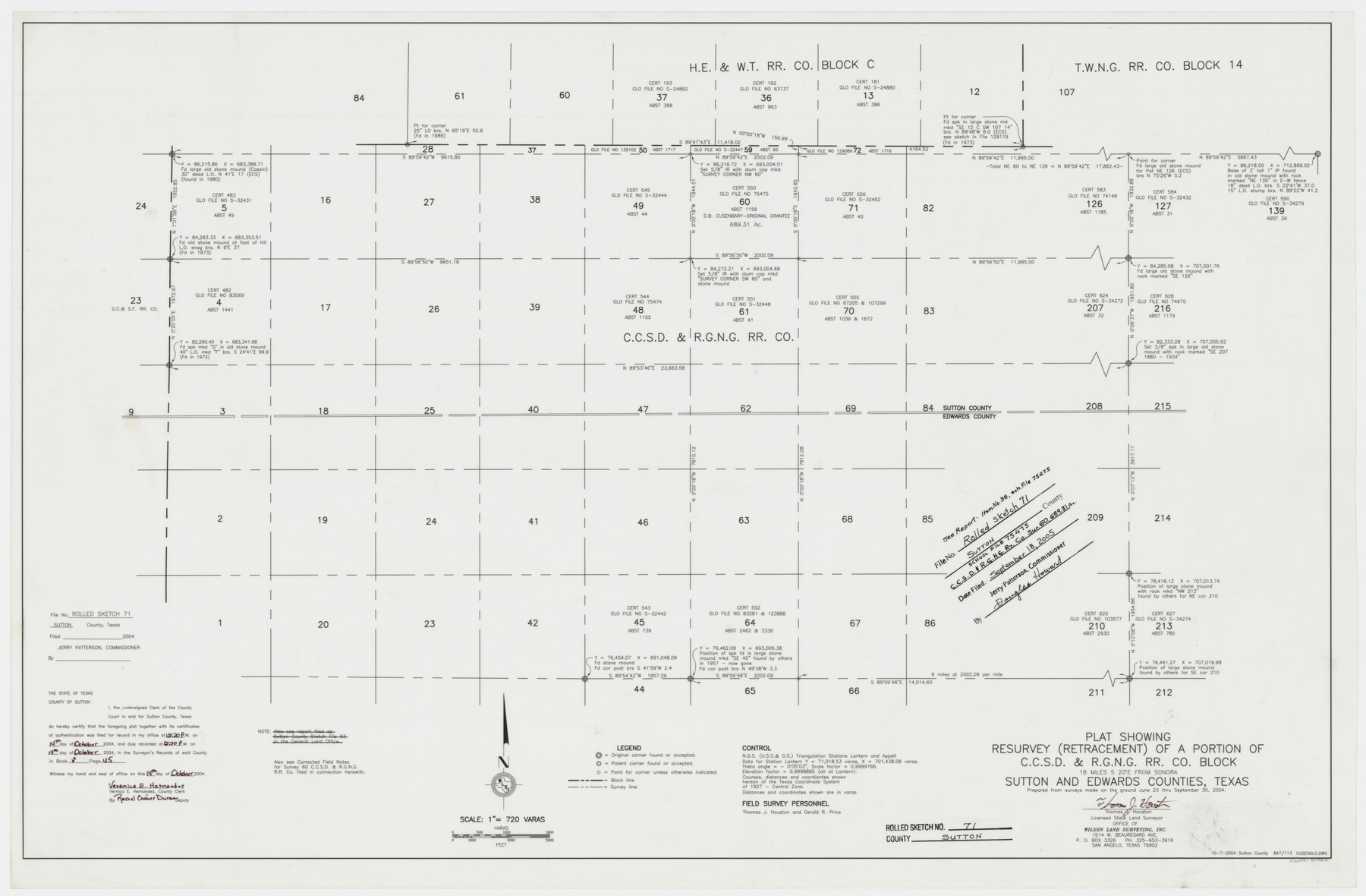
Sutton County Rolled Sketch 71
Plat showing resurvey (retracement) of a portion of C. C. S. D. & R. G. N. G. R.R. Co. Block
-
Map/Doc
83760
-
Collection
General Map Collection
-
Object Dates
2004/9/30 (Survey Date)
2005/9/18 (File Date)
-
People and Organizations
Thomas J. Houston (Surveyor/Engineer)
Gerald R. Price (Chainman/Field Personnel)
-
Counties
Sutton Edwards
-
Subjects
Surveying Rolled Sketch
-
Height x Width
23.1 x 35.3 inches
58.7 x 89.7 cm
-
Medium
mylar, print
-
Scale
1" = 720 varas
-
Comments
See School File 75475 for report.
Part of: General Map Collection
Hardeman County Rolled Sketch 25

Print $20.00
- Digital $50.00
Hardeman County Rolled Sketch 25
1985
Size 20.9 x 15.1 inches
Map/Doc 6075
Archer County Sketch File 27

Print $40.00
- Digital $50.00
Archer County Sketch File 27
Size 19.1 x 21.1 inches
Map/Doc 10833
Township No. 2 South Range No. 22 West of the Indian Meridian

Print $20.00
- Digital $50.00
Township No. 2 South Range No. 22 West of the Indian Meridian
1875
Size 19.2 x 24.3 inches
Map/Doc 75176
Uvalde County Working Sketch 7

Print $20.00
- Digital $50.00
Uvalde County Working Sketch 7
1942
Size 29.2 x 30.0 inches
Map/Doc 72077
Gulf Intracoastal Waterway, Tex. - Aransas Bay to Corpus Christi Bay - Modified Route of Main Channel/Dredging

Print $20.00
- Digital $50.00
Gulf Intracoastal Waterway, Tex. - Aransas Bay to Corpus Christi Bay - Modified Route of Main Channel/Dredging
1958
Size 31.0 x 42.8 inches
Map/Doc 61895
Montgomery County

Print $20.00
- Digital $50.00
Montgomery County
1871
Size 21.5 x 23.9 inches
Map/Doc 4598
Map of Asylum Lands

Print $20.00
- Digital $50.00
Map of Asylum Lands
1857
Size 22.0 x 29.1 inches
Map/Doc 2214
Childress County Rolled Sketch 9E

Print $20.00
- Digital $50.00
Childress County Rolled Sketch 9E
Size 23.8 x 16.6 inches
Map/Doc 78460
Harris County Rolled Sketch 83

Print $20.00
- Digital $50.00
Harris County Rolled Sketch 83
1958
Size 28.2 x 45.6 inches
Map/Doc 9139
Wise County Working Sketch 28

Print $40.00
- Digital $50.00
Wise County Working Sketch 28
1996
Size 37.5 x 48.8 inches
Map/Doc 72642

Galveston Bay

Print $20.00
- Digital $50.00
Galveston Bay
1921
Size 43.4 x 35.4 inches
Map/Doc 69872
You may also like
Duval County Sketch File 82

Print $10.00
- Digital $50.00
Duval County Sketch File 82
1933
Size 11.3 x 8.8 inches
Map/Doc 21516
Plat of Resurvey of Section 36, T. 4S., R. 14W., Indian Meridian, Oklahoma

Print $4.00
- Digital $50.00
Plat of Resurvey of Section 36, T. 4S., R. 14W., Indian Meridian, Oklahoma
1917
Size 18.1 x 22.6 inches
Map/Doc 75152

Shackelford County Working Sketch 14

Print $20.00
- Digital $50.00
Shackelford County Working Sketch 14
2008
Size 47.7 x 29.2 inches
Map/Doc 88835
The Judicial District/County of Waco. Abolished, Spring 1842

Print $20.00
The Judicial District/County of Waco. Abolished, Spring 1842
2020
Size 16.2 x 21.7 inches
Map/Doc 96353
Brewster County Rolled Sketch 22C

Print $20.00
- Digital $50.00
Brewster County Rolled Sketch 22C
1910
Size 23.7 x 18.8 inches
Map/Doc 5204
Donley County Sketch File B3

Print $20.00
- Digital $50.00
Donley County Sketch File B3
1918
Size 22.0 x 15.0 inches
Map/Doc 11373
Block No. 45 of the H. & T. C. R.R. Co. and Block No. 4T of the T. & N. O. R.R. Co. in Hansford and Ochiltree Cos. as resurveyed by J.L. Long, State Surveyor

Print $20.00
- Digital $50.00
Block No. 45 of the H. & T. C. R.R. Co. and Block No. 4T of the T. & N. O. R.R. Co. in Hansford and Ochiltree Cos. as resurveyed by J.L. Long, State Surveyor
1888
Size 34.1 x 28.1 inches
Map/Doc 75820
Polk County Working Sketch 43

Print $20.00
- Digital $50.00
Polk County Working Sketch 43
1997
Size 23.2 x 30.5 inches
Map/Doc 71660
[Texas & Pacific Railway through Callahan County]
![64238, [Texas & Pacific Railway through Callahan County], General Map Collection](https://historictexasmaps.com/wmedia_w700/maps/64238.tif.jpg)
Print $20.00
- Digital $50.00
[Texas & Pacific Railway through Callahan County]
1918
Size 22.4 x 9.4 inches
Map/Doc 64238
Palo Pinto County Sketch File 3

Print $20.00
- Digital $50.00
Palo Pinto County Sketch File 3
1850
Size 24.6 x 19.3 inches
Map/Doc 12132
Panola County Sketch File 8

Print $4.00
- Digital $50.00
Panola County Sketch File 8
1862
Size 12.8 x 7.8 inches
Map/Doc 33459