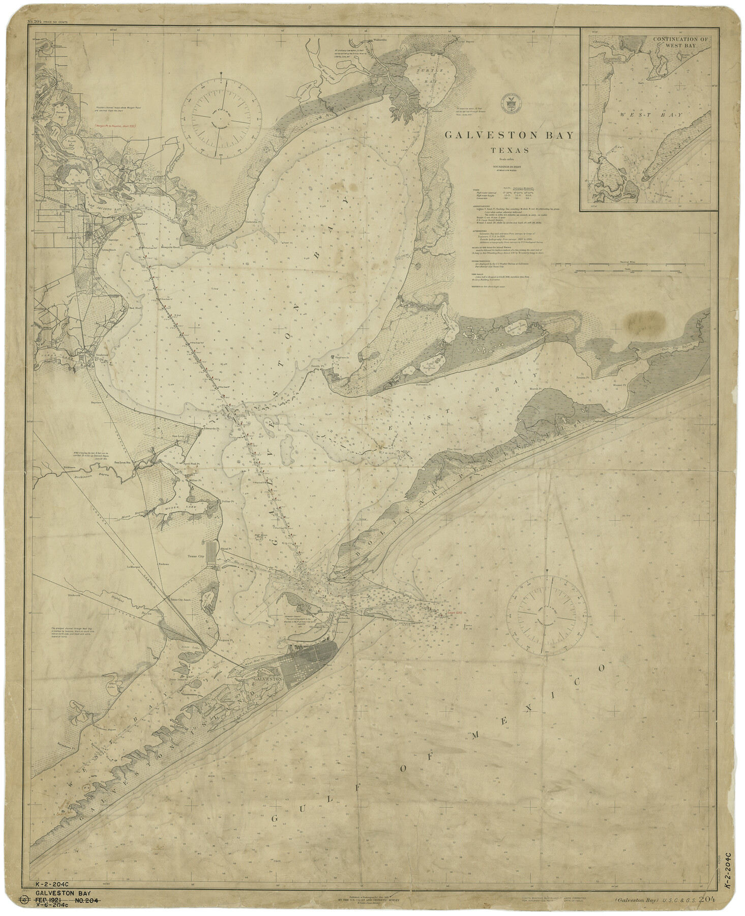
Galveston Bay
K-2-204b
-
Map/Doc
69872
-
Collection
General Map Collection
-
Object Dates
1921 (Creation Date)
-
Counties
Galveston Chambers Harris
-
Subjects
Nautical Charts
-
Height x Width
43.4 x 35.4 inches
110.2 x 89.9 cm
Part of: General Map Collection
Webb County Sketch File 1-2

Print $20.00
- Digital $50.00
Webb County Sketch File 1-2
1912
Size 21.2 x 22.6 inches
Map/Doc 12611
La Salle County Rolled Sketch 21

Print $77.00
- Digital $50.00
La Salle County Rolled Sketch 21
1955
Size 10.0 x 15.1 inches
Map/Doc 46461
Burnet County Working Sketch 27

Print $20.00
- Digital $50.00
Burnet County Working Sketch 27
2025
Size 24.5 x 36.0 inches
Map/Doc 97419
Map of Llano County

Print $20.00
- Digital $50.00
Map of Llano County
1877
Size 19.9 x 25.7 inches
Map/Doc 3824
Culberson County Sketch File 10a

Print $20.00
- Digital $50.00
Culberson County Sketch File 10a
1926
Size 11.9 x 18.3 inches
Map/Doc 11264
Denton County Sketch File 4

Print $6.00
- Digital $50.00
Denton County Sketch File 4
1858
Size 12.2 x 7.9 inches
Map/Doc 20690
Gregg County Sketch File 4

Print $20.00
- Digital $50.00
Gregg County Sketch File 4
1931
Size 22.1 x 16.6 inches
Map/Doc 11586
Refugio County Sketch File 10

Print $4.00
- Digital $50.00
Refugio County Sketch File 10
Size 8.2 x 9.4 inches
Map/Doc 35258
Dépt. des Basses-Alpes

Print $20.00
- Digital $50.00
Dépt. des Basses-Alpes
Size 13.9 x 20.3 inches
Map/Doc 94450
Lampasas County Boundary File 3

Print $10.00
- Digital $50.00
Lampasas County Boundary File 3
Size 8.4 x 7.3 inches
Map/Doc 56101
Frio County Boundary File 31

Print $19.00
- Digital $50.00
Frio County Boundary File 31
Size 9.3 x 4.4 inches
Map/Doc 53609
[Surveys along the Nacogdoches River, Richland Creek, and the Trinity River]
![85, [Surveys along the Nacogdoches River, Richland Creek, and the Trinity River], General Map Collection](https://historictexasmaps.com/wmedia_w700/maps/85.tif.jpg)
Print $20.00
- Digital $50.00
[Surveys along the Nacogdoches River, Richland Creek, and the Trinity River]
1840
Size 24.2 x 17.9 inches
Map/Doc 85
You may also like
Menard County Rolled Sketch 16

Print $20.00
- Digital $50.00
Menard County Rolled Sketch 16
1983
Size 29.8 x 36.6 inches
Map/Doc 6762
Nueces County Rolled Sketch 7

Print $20.00
- Digital $50.00
Nueces County Rolled Sketch 7
Size 37.5 x 34.6 inches
Map/Doc 9585
Crockett County Sketch File 74

Print $22.00
- Digital $50.00
Crockett County Sketch File 74
1933
Size 11.4 x 8.6 inches
Map/Doc 19872
Harris County Rolled Sketch 28(1)

Print $39.00
- Digital $50.00
Harris County Rolled Sketch 28(1)
Size 10.0 x 15.3 inches
Map/Doc 45770
Hansford County Working Sketch 1

Print $40.00
- Digital $50.00
Hansford County Working Sketch 1
1934
Size 43.0 x 54.1 inches
Map/Doc 63373
Denton County

Print $20.00
- Digital $50.00
Denton County
1947
Size 42.5 x 39.7 inches
Map/Doc 73130
Bee County Sketch File 17

Print $4.00
- Digital $50.00
Bee County Sketch File 17
1878
Size 7.9 x 9.9 inches
Map/Doc 14301
Flight Mission No. DAG-17K, Frame 129, Matagorda County

Print $20.00
- Digital $50.00
Flight Mission No. DAG-17K, Frame 129, Matagorda County
1952
Size 18.6 x 22.3 inches
Map/Doc 86349
State Prison System, Cherokee County

Print $20.00
- Digital $50.00
State Prison System, Cherokee County
Size 17.9 x 13.8 inches
Map/Doc 73561
Map of Caldwell County

Print $20.00
- Digital $50.00
Map of Caldwell County
1871
Size 16.9 x 19.8 inches
Map/Doc 4590
Sherman County Rolled Sketch 12

Print $40.00
- Digital $50.00
Sherman County Rolled Sketch 12
1951
Size 11.5 x 64.0 inches
Map/Doc 9931
Fredonia or the United States of North-America; including also Cabotia, or the Canadian Provinces; the Western Territory to the Pacific Ocean; and the Northern Part of the Mexican States

Print $20.00
- Digital $50.00
Fredonia or the United States of North-America; including also Cabotia, or the Canadian Provinces; the Western Territory to the Pacific Ocean; and the Northern Part of the Mexican States
1848
Size 26.8 x 39.9 inches
Map/Doc 93879