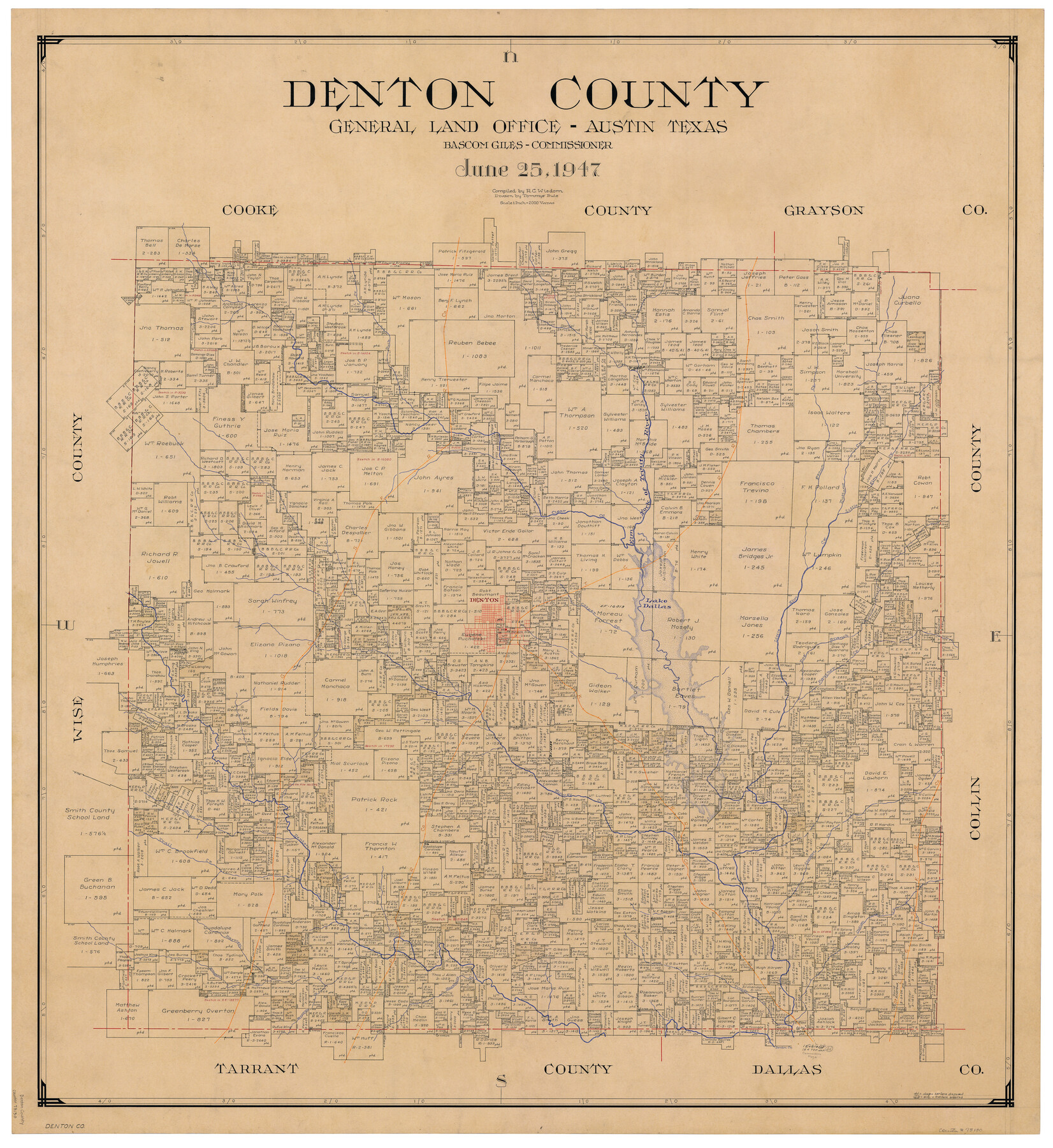
Denton County
-
Map/Doc
73130
-
Collection
General Map Collection
-
Object Dates
6/25/1947 (Creation Date)
-
People and Organizations
Bascom Giles (GLO Commissioner)
Tommye Buie (Draftsman)
R.C. Wisdom (Compiler)
-
Counties
Denton
-
Subjects
County
-
Height x Width
42.5 x 39.7 inches
108.0 x 100.8 cm
-
Comments
Hand lettered.
Note on reverse side: "Compilation completed June 25, 1947. Inking completed December 4, 1947. Tracing completed March 20, 1948. Placed in official use March 23, 1948. Replaced [on sticks] by copy April 17, 1948." -
Features
Lake Dallas
Henrietta Creek
Elizabeth Creek
Harriett Creek
Marshalls Creek
Timber Creek
Indian Creek
Denton Creek
Trail Creek
Oliver Creek
Hickory Creek
Stewarts Creek
Denton
Cooper Creek
SL&SF
Panther Creek
Doe Branch of Little Elm Creek
Clear Creek
Duck Creek
Elm Fork of Trinity River
Little Elm Creek
Mustang Creek
Pecan Creek
MK&T
T&P
GC&SF
Trinity River
Part of: General Map Collection
Gaines County Sketch File 8

Print $40.00
- Digital $50.00
Gaines County Sketch File 8
1941
Size 14.2 x 17.2 inches
Map/Doc 23191
State of Texas

Print $40.00
- Digital $50.00
State of Texas
1948
Size 44.6 x 56.8 inches
Map/Doc 78634
Childress County Rolled Sketch 9E

Print $20.00
- Digital $50.00
Childress County Rolled Sketch 9E
Size 23.8 x 16.6 inches
Map/Doc 78460
Willacy County Aerial Photograph Index Sheet 1

Print $20.00
- Digital $50.00
Willacy County Aerial Photograph Index Sheet 1
1940
Size 24.3 x 20.2 inches
Map/Doc 83756
Victoria County Working Sketch 4

Print $20.00
- Digital $50.00
Victoria County Working Sketch 4
1944
Size 37.0 x 47.6 inches
Map/Doc 72274
Hall County Sketch File 29 and 29a

Print $12.00
- Digital $50.00
Hall County Sketch File 29 and 29a
1913
Size 8.9 x 7.9 inches
Map/Doc 24824
Flight Mission No. BRA-7M, Frame 147, Jefferson County

Print $20.00
- Digital $50.00
Flight Mission No. BRA-7M, Frame 147, Jefferson County
1953
Size 16.2 x 15.9 inches
Map/Doc 85541
Bandera County Rolled Sketch 2

Print $20.00
- Digital $50.00
Bandera County Rolled Sketch 2
1945
Size 19.1 x 24.0 inches
Map/Doc 5114
Hill County Boundary File 2

Print $18.00
- Digital $50.00
Hill County Boundary File 2
Size 10.6 x 8.1 inches
Map/Doc 54734
Van Zandt County

Print $20.00
- Digital $50.00
Van Zandt County
1857
Size 20.0 x 25.3 inches
Map/Doc 8144
Freestone County Sketch File 6

Print $4.00
- Digital $50.00
Freestone County Sketch File 6
1858
Size 10.3 x 8.8 inches
Map/Doc 23050
Flight Mission No. DAG-24K, Frame 125, Matagorda County

Print $20.00
- Digital $50.00
Flight Mission No. DAG-24K, Frame 125, Matagorda County
1953
Size 18.5 x 22.3 inches
Map/Doc 86543
You may also like
Southern Part of Laguna Madre

Print $20.00
- Digital $50.00
Southern Part of Laguna Madre
1946
Size 43.8 x 34.5 inches
Map/Doc 73534
Travis County Boundary File 4a

Print $40.00
- Digital $50.00
Travis County Boundary File 4a
Size 27.9 x 17.8 inches
Map/Doc 59428
The Republic County of Jasper. December 29, 1845

Print $20.00
The Republic County of Jasper. December 29, 1845
2020
Size 19.5 x 21.7 inches
Map/Doc 96196
Hudspeth County Working Sketch 16

Print $40.00
- Digital $50.00
Hudspeth County Working Sketch 16
1957
Size 21.1 x 71.2 inches
Map/Doc 66298
Nueces County Sketch File 16

Print $6.00
- Digital $50.00
Nueces County Sketch File 16
1875
Size 15.5 x 10.7 inches
Map/Doc 32547
Map Showing North and West Boundaries of Gray County

Print $20.00
- Digital $50.00
Map Showing North and West Boundaries of Gray County
Size 39.7 x 19.0 inches
Map/Doc 90709

Ward County Rolled Sketch 24B

Print $40.00
- Digital $50.00
Ward County Rolled Sketch 24B
1967
Size 24.7 x 56.4 inches
Map/Doc 10115
DeWitt County Working Sketch 16

Print $20.00
- Digital $50.00
DeWitt County Working Sketch 16
1920
Size 23.0 x 25.1 inches
Map/Doc 69016
Galveston County NRC Article 33.136 Sketch 18

Print $66.00
- Digital $50.00
Galveston County NRC Article 33.136 Sketch 18
2003
Size 22.4 x 33.9 inches
Map/Doc 78545
Flight Mission No. DAG-24K, Frame 154, Matagorda County

Print $20.00
- Digital $50.00
Flight Mission No. DAG-24K, Frame 154, Matagorda County
1953
Size 18.5 x 22.2 inches
Map/Doc 86568
Duval County Rolled Sketch 29

Print $20.00
- Digital $50.00
Duval County Rolled Sketch 29
1947
Size 16.2 x 25.8 inches
Map/Doc 5746