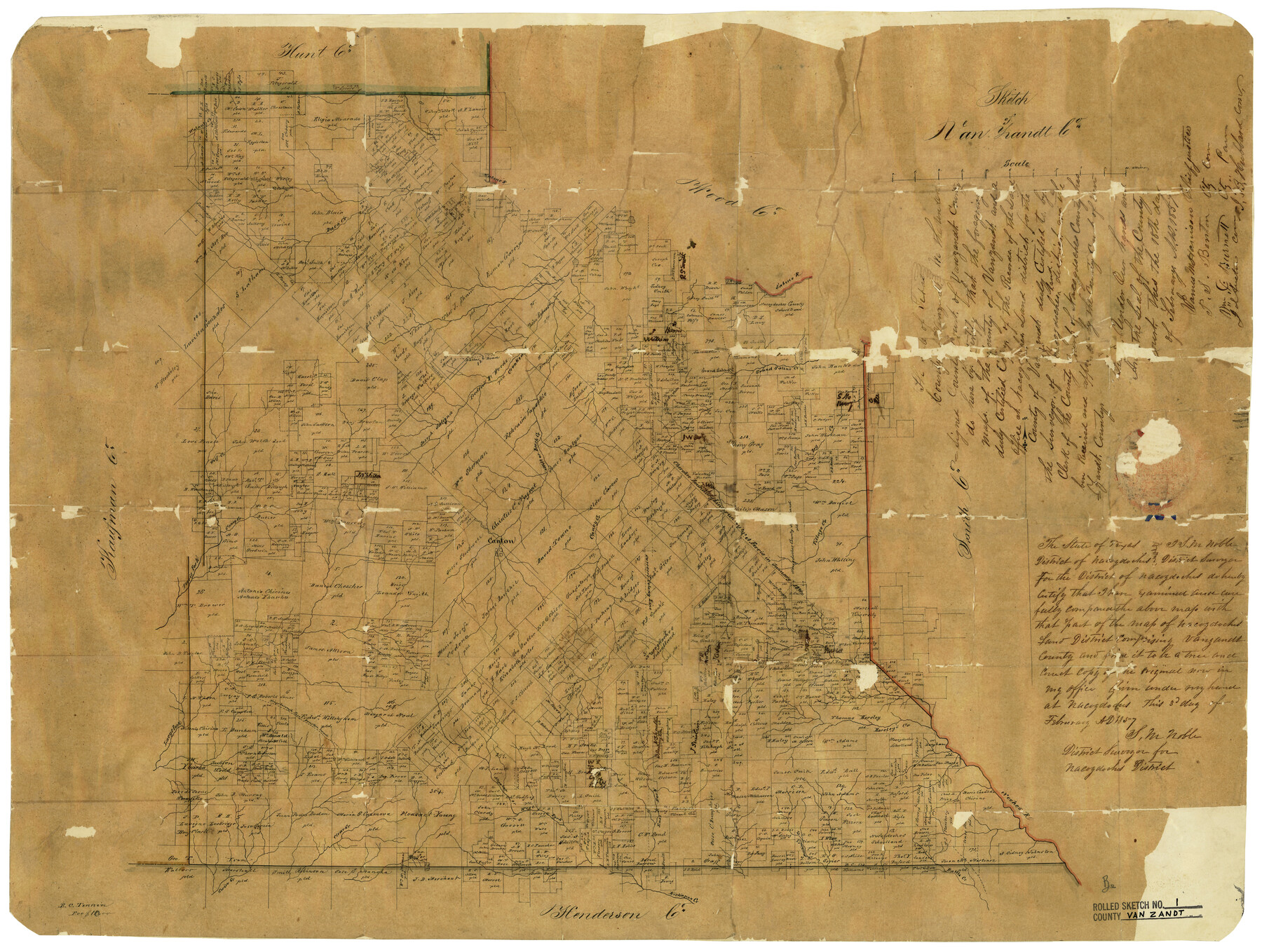
Van Zandt County
Van Zandt County Rolled Sketch 1
- 
                          Map/Doc8144
- 
                            CollectionGeneral Map Collection
- 
                            Object Dates2/3/1857 (Creation Date)
- 
                            People and OrganizationsE.C. Tinnin (Draftsman)S.M. Noble (Surveyor/Engineer)
- 
                            CountiesVan Zandt
- 
                            SubjectsCounty
- 
                            Height x Width20.0 x 25.3 inches50.8 x 64.3 cm
- 
                            CommentsMercer's Colony Line located on map.;
Part of: General Map Collection
            Refugio County Working Sketch 3


                                            Print $20.00                    
                                             -                         Digital $50.00                                    
                Refugio County Working Sketch 3
1927
Size 21.9 x 24.6 inches
                                Map/Doc 63512
            
            Flight Mission No. DIX-8P, Frame 96, Aransas County


                                            Print $20.00                    
                                             -                         Digital $50.00                                    
                Flight Mission No. DIX-8P, Frame 96, Aransas County
1956
Size 18.4 x 22.2 inches
                                Map/Doc 83921
            
            Runnels County Working Sketch 5


                                            Print $20.00                    
                                             -                         Digital $50.00                                    
                Runnels County Working Sketch 5
1907
Size 17.2 x 16.1 inches
                                Map/Doc 63601
            
            Motley County Boundary File 2d


                                            Print $22.00                    
                                             -                         Digital $50.00                                    
                Motley County Boundary File 2d
Size 14.3 x 8.7 inches
                                Map/Doc 57550
            
            Working Sketch Patents & Field Notes, Sabine Lake Area


                                            Print $20.00                    
                                             -                         Digital $50.00                                    
                Working Sketch Patents & Field Notes, Sabine Lake Area
1959
Size 30.2 x 27.0 inches
                                Map/Doc 2455
            
            Jackson County Sketch File 5a


                                            Print $4.00                    
                                             -                         Digital $50.00                                    
                Jackson County Sketch File 5a
1881
Size 8.0 x 9.9 inches
                                Map/Doc 27630
            
            Real County Working Sketch 7


                                            Print $20.00                    
                                             -                         Digital $50.00                                    
                Real County Working Sketch 7
1928
Size 18.4 x 19.4 inches
                                Map/Doc 71899
            
            Map of Polk County


                                            Print $20.00                    
                                             -                         Digital $50.00                                    
                Map of Polk County
1879
Size 27.1 x 20.8 inches
                                Map/Doc 3959
            
            Jackson County Boundary File 1


                                            Print $24.00                    
                                             -                         Digital $50.00                                    
                Jackson County Boundary File 1
Size 9.0 x 3.9 inches
                                Map/Doc 55420
            
            Bee County Working Sketch 3


                                            Print $20.00                    
                                             -                         Digital $50.00                                    
                Bee County Working Sketch 3
1915
Size 22.8 x 20.3 inches
                                Map/Doc 67253
            You may also like
            Zapata County Working Sketch 12


                                            Print $20.00                    
                                             -                         Digital $50.00                                    
                Zapata County Working Sketch 12
1960
Size 30.8 x 24.4 inches
                                Map/Doc 62063
            
            Goliad Station Map, Galveston, Harrisburg & San Antonio Ry. operated by the T. & N. O. R.R. Co.


                                            Print $40.00                    
                                             -                         Digital $50.00                                    
                Goliad Station Map, Galveston, Harrisburg & San Antonio Ry. operated by the T. & N. O. R.R. Co.
1918
Size 24.7 x 55.8 inches
                                Map/Doc 76161
            
            Foard County Boundary File 2


                                            Print $20.00                    
                                             -                         Digital $50.00                                    
                Foard County Boundary File 2
Size 14.3 x 8.8 inches
                                Map/Doc 53504
            
            Val Verde County Sketch File Z21


                                            Print $20.00                    
                                             -                         Digital $50.00                                    
                Val Verde County Sketch File Z21
Size 18.3 x 17.3 inches
                                Map/Doc 12560
            
            Flight Mission No. BRA-16M, Frame 116, Jefferson County


                                            Print $20.00                    
                                             -                         Digital $50.00                                    
                Flight Mission No. BRA-16M, Frame 116, Jefferson County
1953
Size 18.5 x 22.3 inches
                                Map/Doc 85726
            
            Potter County Rolled Sketch 10


                                            Print $20.00                    
                                             -                         Digital $50.00                                    
                Potter County Rolled Sketch 10
1963
Size 31.8 x 43.3 inches
                                Map/Doc 7323
            
            Travis County Appraisal District Plat Map 2_1709


                                            Print $20.00                    
                                             -                         Digital $50.00                                    
                Travis County Appraisal District Plat Map 2_1709
Size 21.6 x 26.5 inches
                                Map/Doc 94210
            
            Mitchell County Sketch File 15


                                            Print $20.00                    
                                             -                         Digital $50.00                                    
                Mitchell County Sketch File 15
1931
Size 19.2 x 19.6 inches
                                Map/Doc 12102
            
            Brewster County Working Sketch 1


                                            Print $20.00                    
                                             -                         Digital $50.00                                    
                Brewster County Working Sketch 1
1904
Size 27.4 x 25.8 inches
                                Map/Doc 67534
            
            [Surveys along the San Marcos River]
            
                                    ![158, [Surveys along the San Marcos River], General Map Collection](https://historictexasmaps.com/wmedia_w700/maps/158.tif.jpg) 


    ![158, [Surveys along the San Marcos River], General Map Collection](https://historictexasmaps.com/wmedia_w700/maps/158.tif.jpg) 
                                
            
                                            Print $2.00                    
                                             -                         Digital $50.00                                    
                [Surveys along the San Marcos River]
Size 7.7 x 5.8 inches
                                Map/Doc 158
            
            Anderson County Working Sketch 7


                                            Print $20.00                    
                                             -                         Digital $50.00                                    
                Anderson County Working Sketch 7
1920
Size 27.3 x 30.2 inches
                                Map/Doc 67006
            
            Medina County Rolled Sketch 5


                                            Print $40.00                    
                                             -                         Digital $50.00                                    
                Medina County Rolled Sketch 5
1948
Size 52.0 x 47.1 inches
                                Map/Doc 9505
             
                         
                                