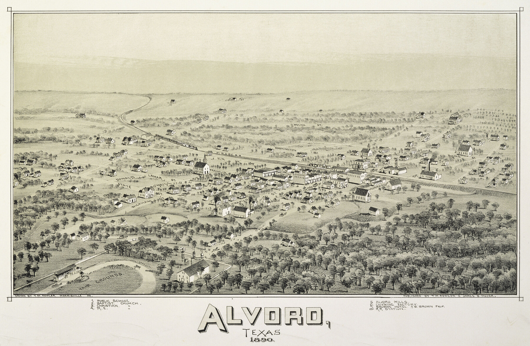
Alvord, Texas
- 
                          Map/Doc89072
- 
                            CollectionNon-GLO Digital Images
- 
                            Object Dates1890 (Creation Date)
- 
                            People and OrganizationsT. M. Fowler, James B. Moyer (Publisher)Thaddeus Mortimer Fowler (Draftsman)
- 
                            CountiesWise
- 
                            SubjectsBird's Eye View City Pictorial
- 
                            Height x Width12.6 x 19.3 inches32.0 x 49.0 cm
- 
                            CommentsBird's Eye View map. Public Domain image obtained from Wikimedia Commons.
Part of: Non-GLO Digital Images
            The Official Map of the City of El Paso, State of Texas


                                            Print $20.00                    
                                    
                The Official Map of the City of El Paso, State of Texas
1889
Size 41.9 x 46.2 inches
                                Map/Doc 89618
            
            Sunset, Montague Co., Texas


                                            Print $20.00                    
                                    
                Sunset, Montague Co., Texas
1890
Size 9.7 x 14.5 inches
                                Map/Doc 89209
            
            Map of the Interior of Louisiana with a part of New Mexico


                                            Print $20.00                    
                                    
                Map of the Interior of Louisiana with a part of New Mexico
1811
Size 11.1 x 14.2 inches
                                Map/Doc 94269
            
            Railroad Commissioner's Map of Texas


                                            Print $20.00                    
                                    
                Railroad Commissioner's Map of Texas
1897
Size 27.0 x 23.0 inches
                                Map/Doc 90070
            
            Karte von Afrika


                                            Print $20.00                    
                                             -                         Digital $50.00                                    
                Karte von Afrika
1888
Size 28.9 x 35.5 inches
                                Map/Doc 97503
            
            Gulf States and Arkansas


                                            Print $20.00                    
                                    
                Gulf States and Arkansas
1874
Size 9.4 x 12.0 inches
                                Map/Doc 95285
            
            Seymour, Baylor County, Texas


                                            Print $20.00                    
                                    
                Seymour, Baylor County, Texas
1890
Size 15.4 x 24.2 inches
                                Map/Doc 89207
            
            Bird's Eye View of Bastrop, Bastrop County, Texas


                                            Print $20.00                    
                                    
                Bird's Eye View of Bastrop, Bastrop County, Texas
1887
Size 18.8 x 25.7 inches
                                Map/Doc 89073
            
            A Map of Austin's Colony and adjacent country in Texas drawn principally from actual survey by Stephen F. Austin


            A Map of Austin's Colony and adjacent country in Texas drawn principally from actual survey by Stephen F. Austin
1820
Size 13.8 x 17.0 inches
                                Map/Doc 93353
            
            [Movements & Objectives of the 143rd & 144th Infantry on October 9-11, 1918, Appendix E, Nos.2 and 3]
            
                                    ![94131, [Movements & Objectives of the 143rd & 144th Infantry on October 9-11, 1918, Appendix E, Nos.2 and 3], Non-GLO Digital Images](https://historictexasmaps.com/wmedia_w700/maps/94131-1.tif.jpg) 


    ![94131, [Movements & Objectives of the 143rd & 144th Infantry on October 9-11, 1918, Appendix E, Nos.2 and 3], Non-GLO Digital Images](https://historictexasmaps.com/wmedia_w700/maps/94131-1.tif.jpg) 
                                
            
                                            Print $20.00                    
                                    
                [Movements & Objectives of the 143rd & 144th Infantry on October 9-11, 1918, Appendix E, Nos.2 and 3]
1918
Size 41.6 x 19.9 inches
                                Map/Doc 94131
            
            Carta Esférica del Seno Mexicano y Canales Viexo y de Bama


            Carta Esférica del Seno Mexicano y Canales Viexo y de Bama
1797
Size 26.7 x 47.1 inches
                                Map/Doc 94569
            You may also like
            Brazos County Sketch File 3


                                            Print $6.00                    
                                             -                         Digital $50.00                                    
                Brazos County Sketch File 3
1861
Size 11.1 x 8.0 inches
                                Map/Doc 15554
            
            Cameron County Rolled Sketch 27


                                            Print $20.00                    
                                             -                         Digital $50.00                                    
                Cameron County Rolled Sketch 27
Size 19.0 x 39.5 inches
                                Map/Doc 5392
            
            Winkler County Working Sketch 10


                                            Print $40.00                    
                                             -                         Digital $50.00                                    
                Winkler County Working Sketch 10
1960
Size 30.3 x 61.0 inches
                                Map/Doc 72604
            
            Fort Bend County State Real Property Sketch 13


                                            Print $40.00                    
                                             -                         Digital $50.00                                    
                Fort Bend County State Real Property Sketch 13
1987
Size 36.3 x 47.9 inches
                                Map/Doc 61687
            
            Harris County Historic Topographic 17


                                            Print $20.00                    
                                             -                         Digital $50.00                                    
                Harris County Historic Topographic 17
1916
Size 29.5 x 22.7 inches
                                Map/Doc 65827
            
            Hardeman County Sketch File 9


                                            Print $20.00                    
                                             -                         Digital $50.00                                    
                Hardeman County Sketch File 9
1884
Size 27.7 x 30.1 inches
                                Map/Doc 11624
            
            Atascosa County Sketch File 3


                                            Print $14.00                    
                                             -                         Digital $50.00                                    
                Atascosa County Sketch File 3
1854
Size 9.1 x 8.6 inches
                                Map/Doc 13730
            
            [Surveys by Brown in Austin's Little Colony along the Colorado River and Walnut Creek]
            
                                    ![196, [Surveys by Brown in Austin's Little Colony along the Colorado River and Walnut Creek], General Map Collection](https://historictexasmaps.com/wmedia_w700/maps/196.tif.jpg) 


    ![196, [Surveys by Brown in Austin's Little Colony along the Colorado River and Walnut Creek], General Map Collection](https://historictexasmaps.com/wmedia_w700/maps/196.tif.jpg) 
                                
            
                                            Print $20.00                    
                                             -                         Digital $50.00                                    
                [Surveys by Brown in Austin's Little Colony along the Colorado River and Walnut Creek]
1832
Size 33.2 x 23.3 inches
                                Map/Doc 196
            
            Topographical Map of the Rio Grande, Sheet No. 15


                                            Print $20.00                    
                                             -                         Digital $50.00                                    
                Topographical Map of the Rio Grande, Sheet No. 15
1912
Map/Doc 89539
            
            The Judicial District/County of Guadalupe. Abolished, Spring 1842


                                            Print $20.00                    
                                    
                The Judicial District/County of Guadalupe. Abolished, Spring 1842
2020
Size 16.7 x 21.7 inches
                                Map/Doc 96328
            
            Brewster County Sketch File 39


                                            Print $4.00                    
                                             -                         Digital $50.00                                    
                Brewster County Sketch File 39
Size 12.8 x 8.9 inches
                                Map/Doc 16300
             
                         
                                