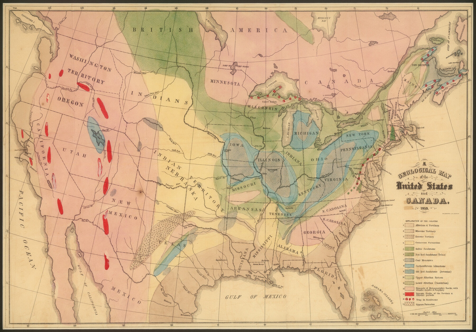
A Geological Map of the United States and Canada
-
Map/Doc
95189
-
Collection
Non-GLO Digital Images
-
Object Dates
1853 (Creation Date)
-
People and Organizations
W.C. Sharp (Printer)
[Edward Hitchcock] (Cartographer)
-
Subjects
United States
-
Height x Width
17.4 x 25.0 inches
44.2 x 63.5 cm
-
Medium
digital image
-
Comments
Digital image courtesy of an anonymous supporter of the Texas General Land Office in 2018.
Part of: Non-GLO Digital Images
Austin, State Capital of Texas

Print $20.00
Austin, State Capital of Texas
1887
Size 27.5 x 40.0 inches
Map/Doc 89218
[WWI Topographic Planning Map of the Ardennes department] - Verso
![94130, [WWI Topographic Planning Map of the Ardennes department] - Verso, Non-GLO Digital Images](https://historictexasmaps.com/wmedia_w700/maps/94130-1.tif.jpg)
Print $20.00
[WWI Topographic Planning Map of the Ardennes department] - Verso
1918
Size 35.9 x 20.4 inches
Map/Doc 94130
J. De Cordova's Map of the State of Texas Compiled from the records of the General Land Office of the State

Print $20.00
J. De Cordova's Map of the State of Texas Compiled from the records of the General Land Office of the State
1849
Size 35.7 x 33.6 inches
Map/Doc 93964

Engineer map showing engineer information at 23 O'Clock 23 Oct. 1918 drawn under direction of Col. W.A. Mitchell

Print $20.00
Engineer map showing engineer information at 23 O'Clock 23 Oct. 1918 drawn under direction of Col. W.A. Mitchell
1918
Size 19.6 x 12.5 inches
Map/Doc 94127
[Movements & Objectives of the 143rd & 144th Infantry and many other divisions and regiments, 1918] - Verso
![94139, [Movements & Objectives of the 143rd & 144th Infantry and many other divisions and regiments, 1918] - Verso, Non-GLO Digital Images](https://historictexasmaps.com/wmedia_w700/maps/94139-1.tif.jpg)
Print $40.00
[Movements & Objectives of the 143rd & 144th Infantry and many other divisions and regiments, 1918] - Verso
1918
Size 37.2 x 63.9 inches
Map/Doc 94139
Karte von Afrika

Print $20.00
- Digital $50.00
Karte von Afrika
1888
Size 28.9 x 35.5 inches
Map/Doc 97503
Carte de la Louisiane et Pays Voisins Pour servir a l'Histoire Generale des Voyages

Print $20.00
Carte de la Louisiane et Pays Voisins Pour servir a l'Histoire Generale des Voyages
1757
Size 9.6 x 14.9 inches
Map/Doc 94572
Sunset, Montague Co., Texas

Print $20.00
Sunset, Montague Co., Texas
1890
Size 9.7 x 14.5 inches
Map/Doc 89209
A Map of Austin's Colony and adjacent country in Texas drawn principally from actual survey by Stephen F. Austin

A Map of Austin's Colony and adjacent country in Texas drawn principally from actual survey by Stephen F. Austin
1820
Size 13.8 x 17.0 inches
Map/Doc 93353
Mapa de Texas con partes de los Estados Adyacentes

Mapa de Texas con partes de los Estados Adyacentes
1832
Size 6.8 x 5.7 inches
Map/Doc 94560

You may also like
Newton County Working Sketch 13

Print $20.00
- Digital $50.00
Newton County Working Sketch 13
1946
Size 34.4 x 34.2 inches
Map/Doc 71259
Flight Mission No. DQN-2K, Frame 188, Calhoun County

Print $20.00
- Digital $50.00
Flight Mission No. DQN-2K, Frame 188, Calhoun County
1953
Size 18.6 x 22.3 inches
Map/Doc 84329
Located Line of the Panhandle & Gulf Ry. through State Lands, Public School and University, Right of Way 200 feet wide, in Brewster County, Texas.

Print $40.00
- Digital $50.00
Located Line of the Panhandle & Gulf Ry. through State Lands, Public School and University, Right of Way 200 feet wide, in Brewster County, Texas.
1904
Size 14.8 x 99.1 inches
Map/Doc 64059
Uvalde County Rolled Sketch 8

Print $20.00
- Digital $50.00
Uvalde County Rolled Sketch 8
Size 21.3 x 37.5 inches
Map/Doc 8093
[Blocks K-7, K-8, Leagues 443-446, 390, 392, 407-410]
![90543, [Blocks K-7, K-8, Leagues 443-446, 390, 392, 407-410], Twichell Survey Records](https://historictexasmaps.com/wmedia_w700/maps/90543-1.tif.jpg)
Print $3.00
- Digital $50.00
[Blocks K-7, K-8, Leagues 443-446, 390, 392, 407-410]
Size 10.4 x 14.2 inches
Map/Doc 90543
Hidalgo County Working Sketch 9

Print $20.00
- Digital $50.00
Hidalgo County Working Sketch 9
1984
Size 27.2 x 15.0 inches
Map/Doc 66186
[North half Dawson County, southwest quarter Lynn County, south half of Terry County, southeast quarter Yoakum County, north half Gaines County]
![93133, [North half Dawson County, southwest quarter Lynn County, south half of Terry County, southeast quarter Yoakum County, north half Gaines County], Twichell Survey Records](https://historictexasmaps.com/wmedia_w700/maps/93133-1.tif.jpg)
Print $40.00
- Digital $50.00
[North half Dawson County, southwest quarter Lynn County, south half of Terry County, southeast quarter Yoakum County, north half Gaines County]
Size 79.8 x 45.3 inches
Map/Doc 93133
Rusk County Working Sketch 37c

Print $20.00
- Digital $50.00
Rusk County Working Sketch 37c
2007
Size 21.2 x 36.0 inches
Map/Doc 87498
Map of Milam County

Print $40.00
- Digital $50.00
Map of Milam County
1839
Size 54.5 x 45.9 inches
Map/Doc 3881
[G. & M. Block 5]
![91802, [G. & M. Block 5], Twichell Survey Records](https://historictexasmaps.com/wmedia_w700/maps/91802-1.tif.jpg)
Print $20.00
- Digital $50.00
[G. & M. Block 5]
Size 20.3 x 12.5 inches
Map/Doc 91802

Throckmorton County Working Sketch 8

Print $20.00
- Digital $50.00
Throckmorton County Working Sketch 8
1958
Size 21.6 x 30.4 inches
Map/Doc 62117