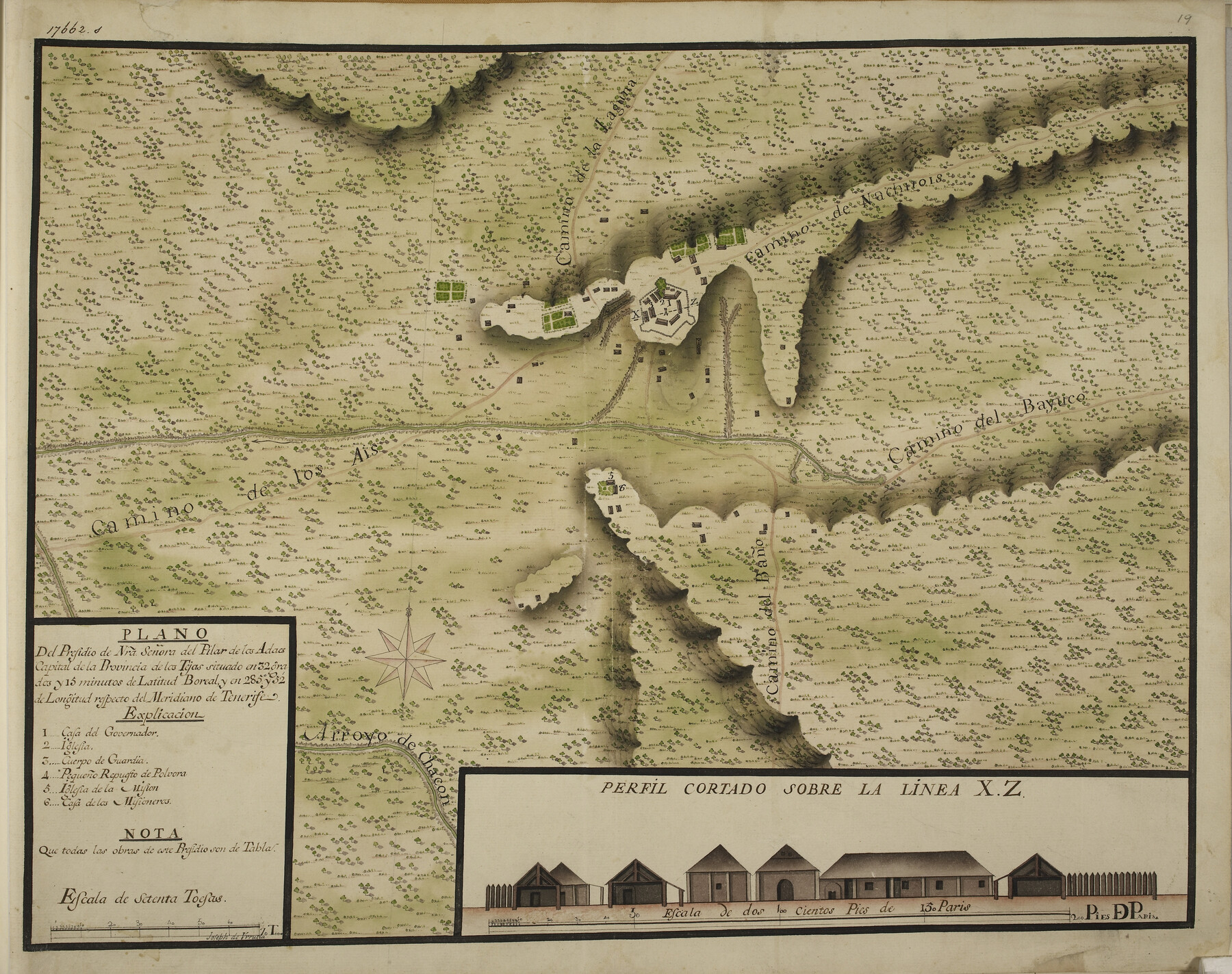
Plano del Presidio de Nra. Senora del Pilar de los Adaes, Capital de la Provincia de los Tejas situado en 32 grados y 15 minutos de Latitud Boreal, y en 285° y 52' de Longitud respecto del Meridiano de Tenerife
-
Map/Doc
96563
-
Collection
Non-GLO Digital Images
-
People and Organizations
Joseph de Urrutia (Cartographer)
-
Subjects
Spanish Texas
-
Height x Width
16.9 x 21.4 inches
42.9 x 54.4 cm
-
Medium
digital image
-
Comments
Map image courtesy of the British Library. For research only, not available for duplication.
For other presidio maps by Joseph de Urrutia, see 96564 and 96565.
Related maps
Primera parte del Mapa, que comprende la Frontera, de los Dominios del Rey, en la America Septentrional

Print $40.00
- Digital $50.00
Primera parte del Mapa, que comprende la Frontera, de los Dominios del Rey, en la America Septentrional
1769
Size 25.8 x 63.2 inches
Map/Doc 3062
Segunda parte del Mapa, que comprende la Frontera, de los Dominios del Rey, en la America Septentrional

Print $40.00
- Digital $50.00
Segunda parte del Mapa, que comprende la Frontera, de los Dominios del Rey, en la America Septentrional
1769
Size 26.7 x 63.8 inches
Map/Doc 4667
Mapa de toda la Frontera de los dominios del Rey en la America septentrional

Print $40.00
Mapa de toda la Frontera de los dominios del Rey en la America septentrional
1771
Size 26.4 x 50.0 inches
Map/Doc 95311
Mapa que comprende la Frontera de los Dominios del Rey, en la America Septentrional, segun el original que hizo D. Joseph de Urrutia, sobre varios puntos observados por él, y el Capitan de Yngenieros D. Nicolas Lafora

Print $40.00
Mapa que comprende la Frontera de los Dominios del Rey, en la America Septentrional, segun el original que hizo D. Joseph de Urrutia, sobre varios puntos observados por él, y el Capitan de Yngenieros D. Nicolas Lafora
1769
Size 50.9 x 128.2 inches
Map/Doc 95711
Plano de la Villa y Presidio de S. Antonio de Vejar situado en la Provincia de Tejas en 29 grad. y 52 minutos de latitud bor. y 275° y 57' de long. contados desde de Meridiano d. Tenerife

Plano de la Villa y Presidio de S. Antonio de Vejar situado en la Provincia de Tejas en 29 grad. y 52 minutos de latitud bor. y 275° y 57' de long. contados desde de Meridiano d. Tenerife
1768
Size 16.8 x 21.2 inches
Map/Doc 96564
Plano del Presidio de Bahia dela Espiritu Santo dependite dela Governacion de los Tejas situado en 29 grad. Y 39 min. de latitud boreal y 277° y 54' dela long. contados desde el Merid. De Tenerife

Plano del Presidio de Bahia dela Espiritu Santo dependite dela Governacion de los Tejas situado en 29 grad. Y 39 min. de latitud boreal y 277° y 54' dela long. contados desde el Merid. De Tenerife
1768
Size 16.7 x 21.0 inches
Map/Doc 96565
Part of: Non-GLO Digital Images
Houston, Texas (Looking South)

Print $20.00
Houston, Texas (Looking South)
1891
Size 25.3 x 41.1 inches
Map/Doc 89094

Greenville, Hunt County Texas

Print $20.00
Greenville, Hunt County Texas
1891
Size 16.4 x 30.0 inches
Map/Doc 89090
[WWI Topographic Planning Map of the Ardennes]
![94129, [WWI Topographic Planning Map of the Ardennes], Non-GLO Digital Images](https://historictexasmaps.com/wmedia_w700/maps/94129-1.tif.jpg)
Print $20.00
[WWI Topographic Planning Map of the Ardennes]
1918
Size 35.8 x 20.2 inches
Map/Doc 94129
[WWI Topographic Planning Map of the Ardennes department] - Verso
![94130, [WWI Topographic Planning Map of the Ardennes department] - Verso, Non-GLO Digital Images](https://historictexasmaps.com/wmedia_w700/maps/94130-1.tif.jpg)
Print $20.00
[WWI Topographic Planning Map of the Ardennes department] - Verso
1918
Size 35.9 x 20.4 inches
Map/Doc 94130
Fort Worth, Tex. "The Queen of the Prairies," County Seat of Tarrant County

Print $20.00
Fort Worth, Tex. "The Queen of the Prairies," County Seat of Tarrant County
1886
Size 26.0 x 33.3 inches
Map/Doc 89082
Clarendon, Texas, Donley Co.

Print $20.00
Clarendon, Texas, Donley Co.
1890
Size 15.7 x 26.6 inches
Map/Doc 89078
Mapa del Presidio de San Antonio de Bexar, i sus Misiones de la Provinsia de Texas

Print $20.00
Mapa del Presidio de San Antonio de Bexar, i sus Misiones de la Provinsia de Texas
1764
Size 14.5 x 18.4 inches
Map/Doc 94455
Plano del Presidio de Nra Senora del Pilar de los Adaes

Plano del Presidio de Nra Senora del Pilar de los Adaes
1766
Size 7.3 x 9.2 inches
Map/Doc 96517
The Rand-McNally New Commercial Atlas Map of Texas

Print $20.00
The Rand-McNally New Commercial Atlas Map of Texas
1914
Size 28.6 x 42.4 inches
Map/Doc 78225
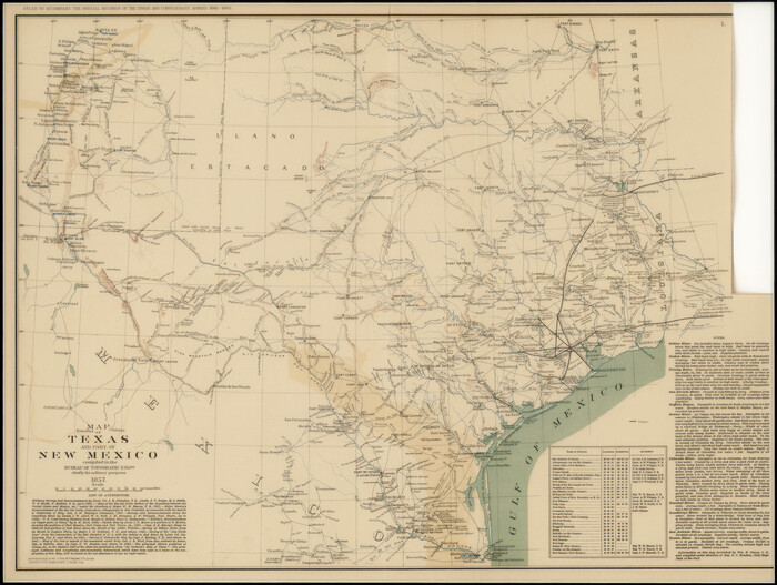
Map of Texas and part of New Mexico
Print $20.00
Map of Texas and part of New Mexico
1857
Size 17.4 x 23.1 inches
Map/Doc 95284
Bird's Eye View of the City of Waco

Print $20.00
Bird's Eye View of the City of Waco
1873
Size 19.6 x 24.0 inches
Map/Doc 89211
You may also like
Flight Mission No. DAH-9M, Frame 202, Orange County

Print $20.00
- Digital $50.00
Flight Mission No. DAH-9M, Frame 202, Orange County
1953
Size 18.5 x 22.6 inches
Map/Doc 86870
Duval County Sketch File 36a

Print $10.00
- Digital $50.00
Duval County Sketch File 36a
1935
Size 11.4 x 8.8 inches
Map/Doc 21380
Austin County Sketch File EF

Print $40.00
- Digital $50.00
Austin County Sketch File EF
1895
Size 15.1 x 17.0 inches
Map/Doc 10879
[Office Sketch of Jesse McGee survey in Sabine and Newton Counties]
![543, [Office Sketch of Jesse McGee survey in Sabine and Newton Counties], Maddox Collection](https://historictexasmaps.com/wmedia_w700/maps/543.tif.jpg)
Print $20.00
- Digital $50.00
[Office Sketch of Jesse McGee survey in Sabine and Newton Counties]
1910
Size 13.4 x 15.1 inches
Map/Doc 543
Irion County Working Sketch 11

Print $20.00
- Digital $50.00
Irion County Working Sketch 11
1959
Size 43.6 x 30.6 inches
Map/Doc 66420
Bee County Boundary File 3

Print $20.00
- Digital $50.00
Bee County Boundary File 3
Size 22.3 x 16.2 inches
Map/Doc 50440
Trinity River, Rockwall Sheet/East Fork of Trinity River

Print $4.00
- Digital $50.00
Trinity River, Rockwall Sheet/East Fork of Trinity River
1936
Size 29.6 x 22.9 inches
Map/Doc 65193
[East Neches River]
![90420, [East Neches River], Twichell Survey Records](https://historictexasmaps.com/wmedia_w700/maps/90420-1.tif.jpg)
Print $20.00
- Digital $50.00
[East Neches River]
Size 25.8 x 29.3 inches
Map/Doc 90420

Flight Mission No. DQO-3K, Frame 14, Galveston County

Print $20.00
- Digital $50.00
Flight Mission No. DQO-3K, Frame 14, Galveston County
1952
Size 18.8 x 22.4 inches
Map/Doc 85055
Stephens County Boundary File 4

Print $6.00
- Digital $50.00
Stephens County Boundary File 4
Size 14.3 x 8.8 inches
Map/Doc 58894
Flight Mission No. CRC-2R, Frame 190, Chambers County

Print $20.00
- Digital $50.00
Flight Mission No. CRC-2R, Frame 190, Chambers County
1956
Size 18.8 x 22.4 inches
Map/Doc 84768