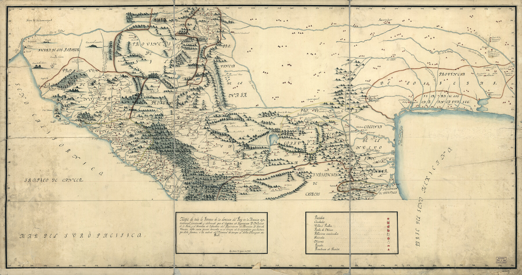
Mapa de toda la Frontera de los dominios del Rey en la America septentrional
-
Map/Doc
95311
-
Collection
Library of Congress
-
Object Dates
1816 (Copy/Tracing Date)
1771 (Creation Date)
-
People and Organizations
Nicolas de la Fora (Explorer)
José de Urrutia (Explorer)
-
Subjects
Mexico Spanish Texas
-
Height x Width
26.4 x 50.0 inches
67.1 x 127.0 cm
-
Medium
digital image
-
Comments
Copied from a 1771 map. For more information see here. Prints available from the GLO courtesy of Library of Congress, Geography and Map Division.
Related maps
Primera parte del Mapa, que comprende la Frontera, de los Dominios del Rey, en la America Septentrional

Print $40.00
- Digital $50.00
Primera parte del Mapa, que comprende la Frontera, de los Dominios del Rey, en la America Septentrional
1769
Size 25.8 x 63.2 inches
Map/Doc 3062
Segunda parte del Mapa, que comprende la Frontera, de los Dominios del Rey, en la America Septentrional

Print $40.00
- Digital $50.00
Segunda parte del Mapa, que comprende la Frontera, de los Dominios del Rey, en la America Septentrional
1769
Size 26.7 x 63.8 inches
Map/Doc 4667
Mapa que comprende la Frontera de los Dominios del Rey, en la America Septentrional, segun el original que hizo D. Joseph de Urrutia, sobre varios puntos observados por él, y el Capitan de Yngenieros D. Nicolas Lafora

Print $40.00
Mapa que comprende la Frontera de los Dominios del Rey, en la America Septentrional, segun el original que hizo D. Joseph de Urrutia, sobre varios puntos observados por él, y el Capitan de Yngenieros D. Nicolas Lafora
1769
Size 50.9 x 128.2 inches
Map/Doc 95711
Plano del Presidio de Nra. Senora del Pilar de los Adaes, Capital de la Provincia de los Tejas situado en 32 grados y 15 minutos de Latitud Boreal, y en 285° y 52' de Longitud respecto del Meridiano de Tenerife

Plano del Presidio de Nra. Senora del Pilar de los Adaes, Capital de la Provincia de los Tejas situado en 32 grados y 15 minutos de Latitud Boreal, y en 285° y 52' de Longitud respecto del Meridiano de Tenerife
Size 16.9 x 21.4 inches
Map/Doc 96563
Plano de la Villa y Presidio de S. Antonio de Vejar situado en la Provincia de Tejas en 29 grad. y 52 minutos de latitud bor. y 275° y 57' de long. contados desde de Meridiano d. Tenerife

Plano de la Villa y Presidio de S. Antonio de Vejar situado en la Provincia de Tejas en 29 grad. y 52 minutos de latitud bor. y 275° y 57' de long. contados desde de Meridiano d. Tenerife
1768
Size 16.8 x 21.2 inches
Map/Doc 96564
Plano del Presidio de Bahia dela Espiritu Santo dependite dela Governacion de los Tejas situado en 29 grad. Y 39 min. de latitud boreal y 277° y 54' dela long. contados desde el Merid. De Tenerife

Plano del Presidio de Bahia dela Espiritu Santo dependite dela Governacion de los Tejas situado en 29 grad. Y 39 min. de latitud boreal y 277° y 54' dela long. contados desde el Merid. De Tenerife
1768
Size 16.7 x 21.0 inches
Map/Doc 96565
Part of: Library of Congress
Perspective Map of Fort Worth, Tex.

Print $20.00
Perspective Map of Fort Worth, Tex.
1891
Size 22.2 x 36.3 inches
Map/Doc 93472
The railroad system of Texas on September 1st, 1883

Print $20.00
The railroad system of Texas on September 1st, 1883
1883
Size 20.1 x 26.8 inches
Map/Doc 93618
Greenville, Tex., County Seat of Hunt County, 1886

Print $20.00
Greenville, Tex., County Seat of Hunt County, 1886
1886
Size 20.4 x 28.3 inches
Map/Doc 93476
Map of Portions of Eastland, Brown and Comanche Counties

Print $20.00
Map of Portions of Eastland, Brown and Comanche Counties
Size 21.7 x 16.7 inches
Map/Doc 88926

Map of Harris County, Texas

Print $20.00
Map of Harris County, Texas
1879
Size 24.8 x 36.0 inches
Map/Doc 88948

G. Woolworth Colton's new guide map of the United States & Canada, with railroads, counties, etc.

Print $20.00
G. Woolworth Colton's new guide map of the United States & Canada, with railroads, counties, etc.
1862
Size 30.3 x 36.6 inches
Map/Doc 93614


Carta General de la República Mexicana formada por Antonio García y Cubas

Print $40.00
Carta General de la República Mexicana formada por Antonio García y Cubas
1863
Size 48.7 x 57.1 inches
Map/Doc 95307
![88993, San Jacinto Co[unty], Library of Congress](https://historictexasmaps.com/wmedia_w700/maps/88993.tif.jpg)
You may also like
Harris County Working Sketch 58

Print $20.00
- Digital $50.00
Harris County Working Sketch 58
1952
Size 24.1 x 26.5 inches
Map/Doc 65950
Lee County Working Sketch 17

Print $20.00
- Digital $50.00
Lee County Working Sketch 17
1988
Size 31.8 x 32.2 inches
Map/Doc 70396
[T. & P. Block 43, Township 1N]
![90827, [T. & P. Block 43, Township 1N], Twichell Survey Records](https://historictexasmaps.com/wmedia_w700/maps/90827-2.tif.jpg)
Print $20.00
- Digital $50.00
[T. & P. Block 43, Township 1N]
Size 23.0 x 17.8 inches
Map/Doc 90827
Reeves County Rolled Sketch 21

Print $20.00
- Digital $50.00
Reeves County Rolled Sketch 21
1978
Size 27.6 x 27.6 inches
Map/Doc 7489
In the Supreme Court of the United States, The State of Oklahoma, Complainant vs. The State of Texas, Defendant, The United States of America, Intervener, Red River Valley, Texas and Oklahoma Between the 98th and 100th Meridians in Five Sheets, 1921

Print $40.00
- Digital $50.00
In the Supreme Court of the United States, The State of Oklahoma, Complainant vs. The State of Texas, Defendant, The United States of America, Intervener, Red River Valley, Texas and Oklahoma Between the 98th and 100th Meridians in Five Sheets, 1921
1921
Size 37.2 x 59.5 inches
Map/Doc 75274
Limestone County Working Sketch 20

Print $20.00
- Digital $50.00
Limestone County Working Sketch 20
1976
Size 41.5 x 42.3 inches
Map/Doc 70570
Matagorda County Sketch File 3

Print $4.00
- Digital $50.00
Matagorda County Sketch File 3
1876
Size 12.9 x 8.0 inches
Map/Doc 30732

Working Sketch in Deaf Smith County [east of Block K3]
![90605, Working Sketch in Deaf Smith County [east of Block K3], Twichell Survey Records](https://historictexasmaps.com/wmedia_w700/maps/90605-1.tif.jpg)
Print $20.00
- Digital $50.00
Working Sketch in Deaf Smith County [east of Block K3]
1919
Size 15.2 x 27.9 inches
Map/Doc 90605
National Railways of Mexico

Digital $50.00
National Railways of Mexico
1966
Size 8.9 x 17.6 inches
Map/Doc 94189
Flight Mission No. CGI-3N, Frame 109, Cameron County

Print $20.00
- Digital $50.00
Flight Mission No. CGI-3N, Frame 109, Cameron County
1954
Size 18.5 x 22.1 inches
Map/Doc 84589
Lubbock County Sketch File 11

Print $22.00
- Digital $50.00
Lubbock County Sketch File 11
1914
Size 11.2 x 8.8 inches
Map/Doc 30434