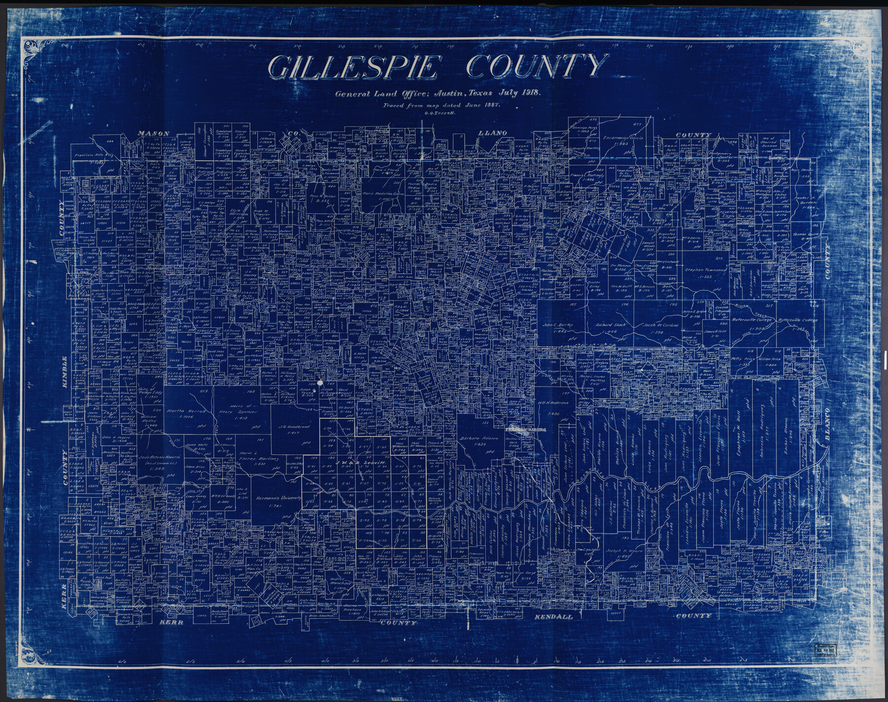
Gillespie County
-
Map/Doc
88942
-
Collection
Library of Congress
-
Object Dates
7/1918 (Creation Date)
-
People and Organizations
General Land Office (Publisher)
O.O. Terrell (Draftsman)
-
Counties
Gillespie
-
Subjects
County
-
Height x Width
38.1 x 48.3 inches
96.8 x 122.7 cm
-
Comments
For more information see here. Prints available from the GLO courtesy of Library of Congress, Geography and Map Division. Tracing of an 1887 map of Gillespie County.
Part of: Library of Congress


Map of McMullen County

Print $20.00
Map of McMullen County
1879
Size 28.6 x 19.3 inches
Map/Doc 88975

Map showing the route of the Louisville, New Orleans, and Texas Railroad and its connecting lines.

Print $20.00
Map showing the route of the Louisville, New Orleans, and Texas Railroad and its connecting lines.
1883
Size 18.1 x 44.1 inches
Map/Doc 93605

Map of Bexar County Showing Subdivisions of Original Surveys and Names of Present Owners

Print $20.00
Map of Bexar County Showing Subdivisions of Original Surveys and Names of Present Owners
1897
Size 46.2 x 41.3 inches
Map/Doc 88908

Waco, Tex., County Seat of McLennan Co.

Print $20.00
Waco, Tex., County Seat of McLennan Co.
1886
Size 16.9 x 30.7 inches
Map/Doc 93473

Roberts County, State of Texas

Print $20.00
Roberts County, State of Texas
1888
Size 21.6 x 16.4 inches
Map/Doc 88990
A new and complete county map of all the rail roads in the United States & Canadas in operation & progress.

Print $20.00
A new and complete county map of all the rail roads in the United States & Canadas in operation & progress.
1857
Size 19.3 x 22.0 inches
Map/Doc 93606
You may also like
Map of Brown County

Print $20.00
- Digital $50.00
Map of Brown County
Size 25.4 x 23.5 inches
Map/Doc 3340
Key to Photo Index Sheets of Texas Coast Portion

Print $20.00
- Digital $50.00
Key to Photo Index Sheets of Texas Coast Portion
1954
Size 20.0 x 24.0 inches
Map/Doc 83437
Montgomery County Working Sketch 41

Print $20.00
- Digital $50.00
Montgomery County Working Sketch 41
1955
Size 22.9 x 23.6 inches
Map/Doc 71148
Oil Map of Texas and Oklahoma showing the location and approximate area of the Oil and Gas Fields

Print $20.00
- Digital $50.00
Oil Map of Texas and Oklahoma showing the location and approximate area of the Oil and Gas Fields
1920
Size 20.8 x 23.9 inches
Map/Doc 95897
Comanche County Sketch File 22

Print $4.00
- Digital $50.00
Comanche County Sketch File 22
1873
Size 15.2 x 9.2 inches
Map/Doc 19106
Flight Mission No. DQN-2K, Frame 65, Calhoun County

Print $20.00
- Digital $50.00
Flight Mission No. DQN-2K, Frame 65, Calhoun County
1953
Size 18.5 x 22.2 inches
Map/Doc 84257
[Blocks 44, 6T, 2G, and Vicinity]
![91519, [Blocks 44, 6T, 2G, and Vicinity], Twichell Survey Records](https://historictexasmaps.com/wmedia_w700/maps/91519-1.tif.jpg)
Print $20.00
- Digital $50.00
[Blocks 44, 6T, 2G, and Vicinity]
Size 24.5 x 16.9 inches
Map/Doc 91519
Travis County Working Sketch 54

Print $20.00
- Digital $50.00
Travis County Working Sketch 54
1976
Size 30.1 x 32.0 inches
Map/Doc 69438
Archer County Working Sketch 22

Print $20.00
- Digital $50.00
Archer County Working Sketch 22
1980
Size 36.4 x 38.0 inches
Map/Doc 67163
Hale County Rolled Sketch 6

Print $20.00
- Digital $50.00
Hale County Rolled Sketch 6
1903
Size 35.0 x 28.9 inches
Map/Doc 6045
Ward County Sketch File 5

Print $5.00
- Digital $50.00
Ward County Sketch File 5
1873
Size 11.0 x 17.0 inches
Map/Doc 39619
[Map of Zapata County]
![4178, [Map of Zapata County], General Map Collection](https://historictexasmaps.com/wmedia_w700/maps/4178.tif.jpg)
Print $20.00
- Digital $50.00
[Map of Zapata County]
1883
Size 20.5 x 20.9 inches
Map/Doc 4178