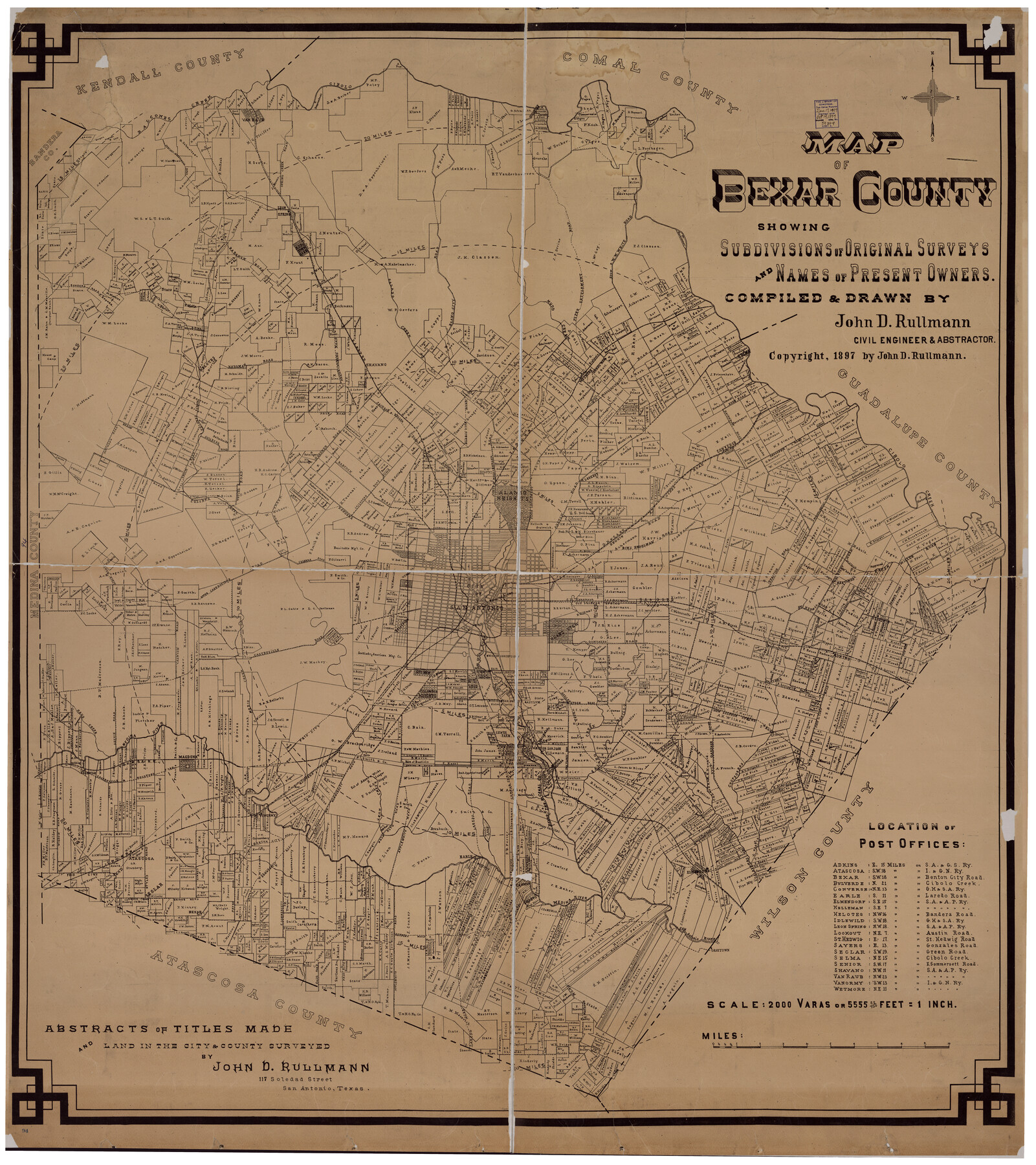
Map of Bexar County Showing Subdivisions of Original Surveys and Names of Present Owners
-
Map/Doc
88908
-
Collection
Library of Congress
-
Object Dates
1897 (Creation Date)
-
People and Organizations
John D. Rullmann (Compiler)
John D. Rullmann (Draftsman)
John D. Rullmann (Surveyor/Engineer)
-
Counties
Bexar
-
Subjects
County
-
Height x Width
46.2 x 41.3 inches
117.4 x 104.9 cm
-
Comments
Prints available from the GLO courtesy of Library of Congress, Geography and Map Division.
Part of: Library of Congress
Interpretative map of wind erodibility. Gaines County, Texas

Interpretative map of wind erodibility. Gaines County, Texas
1986
Size 27.6 x 36.2 inches
Map/Doc 93561

Croquis del terro, camino, bosques, barrancas, cerro y beredas de Cerro-gordo con las posiciones de las topas Mejicanas y Americanas con sus respectivos Generales Cuerpos y Baterias el dis 18 de Abril de 1847

Print $20.00
Croquis del terro, camino, bosques, barrancas, cerro y beredas de Cerro-gordo con las posiciones de las topas Mejicanas y Americanas con sus respectivos Generales Cuerpos y Baterias el dis 18 de Abril de 1847
1847
Size 20.1 x 26.0 inches
Map/Doc 97343
Map of Texas With Parts of the Adjoining States

Print $20.00
Map of Texas With Parts of the Adjoining States
1837
Size 29.9 x 25.2 inches
Map/Doc 88998
The railroad system of Texas on September 1st, 1883

Print $20.00
The railroad system of Texas on September 1st, 1883
1883
Size 20.1 x 26.8 inches
Map/Doc 93618
Map of Wilbarger County, Texas

Print $20.00
Map of Wilbarger County, Texas
1887
Size 11.8 x 8.7 inches
Map/Doc 93587
Fort Worth, Tex. "The Queen of the Prairies", County Seat of Tarrant County

Print $20.00
Fort Worth, Tex. "The Queen of the Prairies", County Seat of Tarrant County
1886
Size 28.8 x 38.6 inches
Map/Doc 93470
Map of Kinney County, Texas

Print $20.00
Map of Kinney County, Texas
1884
Size 25.4 x 35.2 inches
Map/Doc 88966

Map of the County of Galveston

Print $20.00
Map of the County of Galveston
1902
Size 18.5 x 26.4 inches
Map/Doc 93584
Pocket Map Showing the Railroads, Street Railways, Manufactories, Deep Water Connections, Blocks and Subdivisions of the City of Houston

Print $20.00
Pocket Map Showing the Railroads, Street Railways, Manufactories, Deep Water Connections, Blocks and Subdivisions of the City of Houston
1890
Size 35.5 x 29.8 inches
Map/Doc 93487
Map showing the Houston & Texas Central Railroad and its connections

Print $20.00
Map showing the Houston & Texas Central Railroad and its connections
1867
Size 22.0 x 25.2 inches
Map/Doc 93604
You may also like
General Highway Map, San Jacinto County, Texas

Print $20.00
General Highway Map, San Jacinto County, Texas
1940
Size 24.9 x 18.4 inches
Map/Doc 79236
Kimble County Sketch File 16

Print $30.00
- Digital $50.00
Kimble County Sketch File 16
1886
Size 8.5 x 7.9 inches
Map/Doc 28942
[Beaumont, Sour Lake and Western Ry. Right of Way and Alignment - Frisco]
![64131, [Beaumont, Sour Lake and Western Ry. Right of Way and Alignment - Frisco], General Map Collection](https://historictexasmaps.com/wmedia_w700/maps/64131.tif.jpg)
Print $20.00
- Digital $50.00
[Beaumont, Sour Lake and Western Ry. Right of Way and Alignment - Frisco]
1910
Size 20.3 x 46.2 inches
Map/Doc 64131
Nueces County Sketch File 25

Print $14.00
- Digital $50.00
Nueces County Sketch File 25
1876
Size 8.7 x 6.3 inches
Map/Doc 32572
Rusk County Sketch File 11

Print $4.00
Rusk County Sketch File 11
1849
Size 8.5 x 9.1 inches
Map/Doc 35509
[Sketch N, showing Blocks C-10, C-14 through C-16]
![91772, [Sketch N, showing Blocks C-10, C-14 through C-16], Twichell Survey Records](https://historictexasmaps.com/wmedia_w700/maps/91772-1.tif.jpg)
Print $20.00
- Digital $50.00
[Sketch N, showing Blocks C-10, C-14 through C-16]
Size 38.6 x 22.1 inches
Map/Doc 91772
Original Town of Nadine, Lea County, New Mexico

Print $20.00
- Digital $50.00
Original Town of Nadine, Lea County, New Mexico
1928
Size 27.6 x 34.0 inches
Map/Doc 92434
Burleson County Working Sketch 31

Print $40.00
- Digital $50.00
Burleson County Working Sketch 31
1981
Size 70.6 x 37.8 inches
Map/Doc 67750
Webb County Sketch File 1-1

Print $4.00
- Digital $50.00
Webb County Sketch File 1-1
1857
Size 8.6 x 8.4 inches
Map/Doc 39708
Smith County Sketch File 16

Print $116.00
- Digital $50.00
Smith County Sketch File 16
1966
Size 10.8 x 7.3 inches
Map/Doc 36781
Pecos County Rolled Sketch 16

Print $40.00
- Digital $50.00
Pecos County Rolled Sketch 16
1882
Size 42.0 x 65.9 inches
Map/Doc 9682
General Highway Map, Brooks County, Texas

Print $20.00
General Highway Map, Brooks County, Texas
1940
Size 18.5 x 25.0 inches
Map/Doc 79030