Atascosa County Sketch File 23

Print $40.00
- Digital $50.00
Atascosa County Sketch File 23
Size: 17.1 x 21.2 inches
10860
Bandera County Sketch File 10

Print $40.00
- Digital $50.00
Bandera County Sketch File 10
Size: 15.0 x 17.4 inches
10892
Bexar County Sketch File 29

Print $40.00
- Digital $50.00
Bexar County Sketch File 29
Size: 11.3 x 36.7 inches
10919
Bexar County Sketch File 31

Print $40.00
- Digital $50.00
Bexar County Sketch File 31
1867
Size: 11.3 x 16.4 inches
10920
Bexar County Sketch File 36b

Print $40.00
- Digital $50.00
Bexar County Sketch File 36b
Size: 18.6 x 20.2 inches
10921
Bexar County Sketch File 36c

Print $20.00
- Digital $50.00
Bexar County Sketch File 36c
1874
Size: 19.3 x 26.4 inches
10922
Bexar County Sketch File 36d

Print $40.00
- Digital $50.00
Bexar County Sketch File 36d
1878
Size: 21.1 x 26.0 inches
10923
Bexar County Sketch File 46

Print $40.00
- Digital $50.00
Bexar County Sketch File 46
1888
Size: 24.7 x 22.6 inches
10924
Bexar County Sketch File 47

Print $40.00
- Digital $50.00
Bexar County Sketch File 47
1896
Size: 9.9 x 19.6 inches
10925
Bexar County Sketch File 50

Print $40.00
- Digital $50.00
Bexar County Sketch File 50
1874
Size: 22.5 x 18.2 inches
10926
Bexar County Sketch File 56

Print $40.00
- Digital $50.00
Bexar County Sketch File 56
1966
Size: 19.7 x 23.8 inches
10927
Medina County Sketch File 7

Print $20.00
- Digital $50.00
Medina County Sketch File 7
Size: 25.0 x 10.6 inches
12067
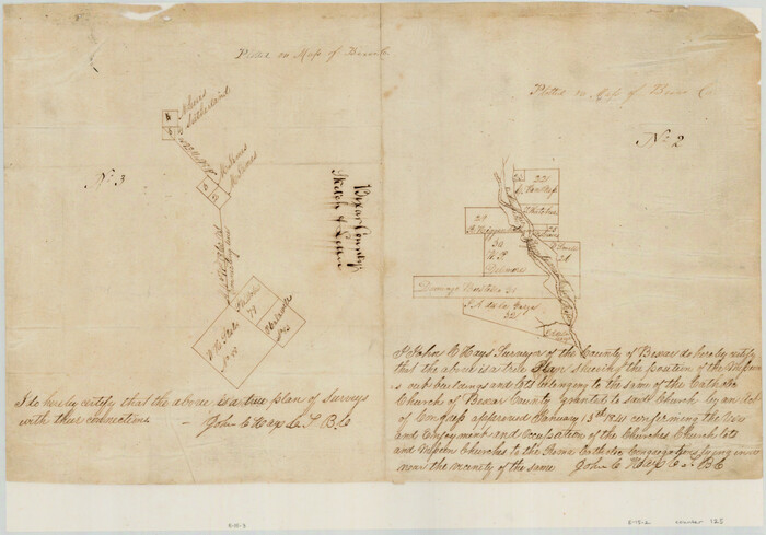
[Surveys in the Bexar District along the San Antonio River showing the position of the missions]
Print $3.00
- Digital $50.00
[Surveys in the Bexar District along the San Antonio River showing the position of the missions]
1841
Size: 11.2 x 16.0 inches
125
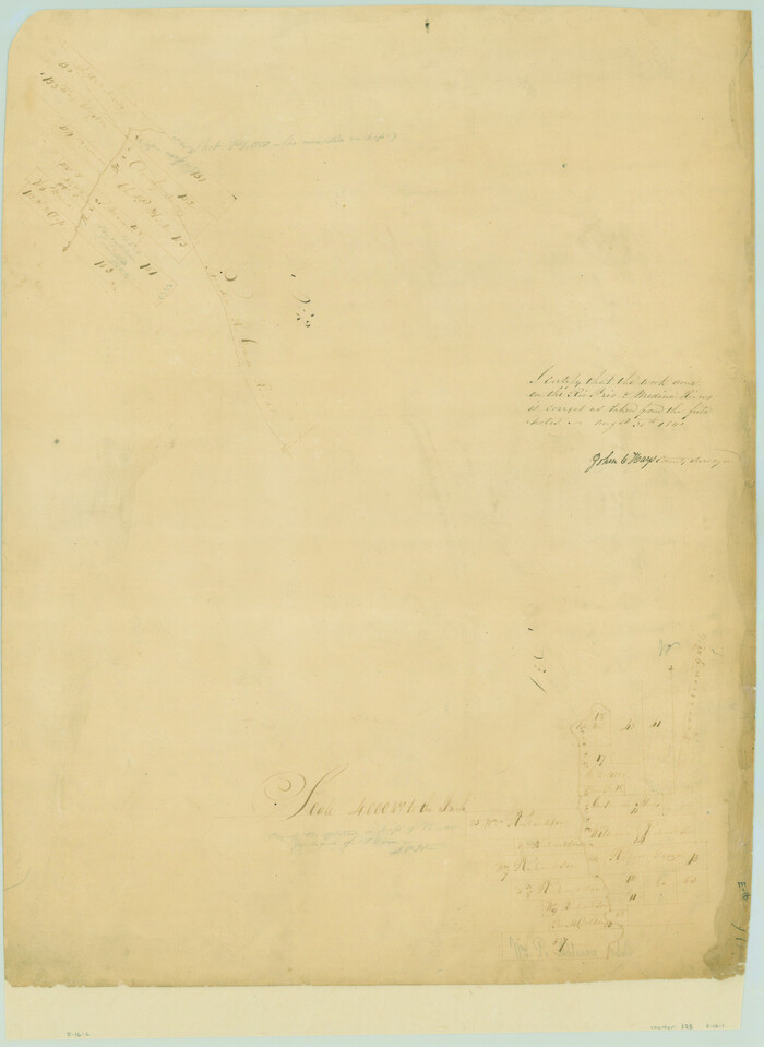
[Surveys in the Bexar District along the Medina River]
Print $20.00
- Digital $50.00
[Surveys in the Bexar District along the Medina River]
1841
Size: 23.0 x 16.8 inches
128
Atascosa County Sketch File 13

Print $4.00
- Digital $50.00
Atascosa County Sketch File 13
1867
Size: 12.8 x 8.2 inches
13771
Atascosa County Sketch File 14

Print $40.00
- Digital $50.00
Atascosa County Sketch File 14
1870
Size: 12.5 x 15.0 inches
13773
Bexar County Sketch File X

Print $4.00
- Digital $50.00
Bexar County Sketch File X
1878
Size: 8.0 x 10.5 inches
14463
Bexar County Sketch File 1

Print $42.00
- Digital $50.00
Bexar County Sketch File 1
1848
Size: 12.5 x 16.2 inches
14465
Bexar County Sketch File 1a

Print $24.00
- Digital $50.00
Bexar County Sketch File 1a
1847
Size: 12.7 x 8.2 inches
14468
Bexar County Sketch File 2

Print $4.00
- Digital $50.00
Bexar County Sketch File 2
1849
Size: 9.1 x 8.3 inches
14471
Bexar County Sketch File 3

Print $4.00
- Digital $50.00
Bexar County Sketch File 3
Size: 12.8 x 8.3 inches
14473
Bexar County Sketch File 7

Print $4.00
- Digital $50.00
Bexar County Sketch File 7
1861
Size: 8.0 x 12.9 inches
14475
Bexar County Sketch File 8

Print $4.00
- Digital $50.00
Bexar County Sketch File 8
Size: 9.4 x 7.7 inches
14477
Bexar County Sketch File 9

Print $4.00
- Digital $50.00
Bexar County Sketch File 9
1853
Size: 8.2 x 13.2 inches
14479
Bexar County Sketch File 11

Print $2.00
- Digital $50.00
Bexar County Sketch File 11
Size: 8.3 x 9.5 inches
14481
Bexar County Sketch File 14

Print $4.00
- Digital $50.00
Bexar County Sketch File 14
1855
Size: 7.8 x 8.2 inches
14482
Bexar County Sketch File 21

Print $4.00
- Digital $50.00
Bexar County Sketch File 21
1859
Size: 12.2 x 7.9 inches
14484
Bexar County Sketch File 25

Print $4.00
- Digital $50.00
Bexar County Sketch File 25
1860
Size: 8.9 x 8.7 inches
14486
Bexar County Sketch File 26

Print $4.00
- Digital $50.00
Bexar County Sketch File 26
1860
Size: 8.6 x 10.8 inches
14488
Bexar County Sketch File 27

Print $4.00
- Digital $50.00
Bexar County Sketch File 27
1860
Size: 8.6 x 6.5 inches
14490
Atascosa County Sketch File 23
Print $40.00
- Digital $50.00
Atascosa County Sketch File 23
-
Size
17.1 x 21.2 inches
-
Map/Doc
10860
Bandera County Sketch File 10
Print $40.00
- Digital $50.00
Bandera County Sketch File 10
-
Size
15.0 x 17.4 inches
-
Map/Doc
10892
Bexar County Sketch File 29
Print $40.00
- Digital $50.00
Bexar County Sketch File 29
-
Size
11.3 x 36.7 inches
-
Map/Doc
10919
Bexar County Sketch File 31
Print $40.00
- Digital $50.00
Bexar County Sketch File 31
1867
-
Size
11.3 x 16.4 inches
-
Map/Doc
10920
-
Creation Date
1867
Bexar County Sketch File 36b
Print $40.00
- Digital $50.00
Bexar County Sketch File 36b
-
Size
18.6 x 20.2 inches
-
Map/Doc
10921
Bexar County Sketch File 36c
Print $20.00
- Digital $50.00
Bexar County Sketch File 36c
1874
-
Size
19.3 x 26.4 inches
-
Map/Doc
10922
-
Creation Date
1874
Bexar County Sketch File 36d
Print $40.00
- Digital $50.00
Bexar County Sketch File 36d
1878
-
Size
21.1 x 26.0 inches
-
Map/Doc
10923
-
Creation Date
1878
Bexar County Sketch File 46
Print $40.00
- Digital $50.00
Bexar County Sketch File 46
1888
-
Size
24.7 x 22.6 inches
-
Map/Doc
10924
-
Creation Date
1888
Bexar County Sketch File 47
Print $40.00
- Digital $50.00
Bexar County Sketch File 47
1896
-
Size
9.9 x 19.6 inches
-
Map/Doc
10925
-
Creation Date
1896
Bexar County Sketch File 50
Print $40.00
- Digital $50.00
Bexar County Sketch File 50
1874
-
Size
22.5 x 18.2 inches
-
Map/Doc
10926
-
Creation Date
1874
Bexar County Sketch File 56
Print $40.00
- Digital $50.00
Bexar County Sketch File 56
1966
-
Size
19.7 x 23.8 inches
-
Map/Doc
10927
-
Creation Date
1966
Medina County Sketch File 7
Print $20.00
- Digital $50.00
Medina County Sketch File 7
-
Size
25.0 x 10.6 inches
-
Map/Doc
12067
[Surveys in the Bexar District along the San Antonio River showing the position of the missions]
Print $3.00
- Digital $50.00
[Surveys in the Bexar District along the San Antonio River showing the position of the missions]
1841
-
Size
11.2 x 16.0 inches
-
Map/Doc
125
-
Creation Date
1841
[Surveys in the Bexar District along the Medina River]
Print $20.00
- Digital $50.00
[Surveys in the Bexar District along the Medina River]
1841
-
Size
23.0 x 16.8 inches
-
Map/Doc
128
-
Creation Date
1841
Atascosa County Sketch File 13
Print $4.00
- Digital $50.00
Atascosa County Sketch File 13
1867
-
Size
12.8 x 8.2 inches
-
Map/Doc
13771
-
Creation Date
1867
Atascosa County Sketch File 14
Print $40.00
- Digital $50.00
Atascosa County Sketch File 14
1870
-
Size
12.5 x 15.0 inches
-
Map/Doc
13773
-
Creation Date
1870
Bexar County Sketch File X
Print $4.00
- Digital $50.00
Bexar County Sketch File X
1878
-
Size
8.0 x 10.5 inches
-
Map/Doc
14463
-
Creation Date
1878
Bexar County Sketch File 1
Print $42.00
- Digital $50.00
Bexar County Sketch File 1
1848
-
Size
12.5 x 16.2 inches
-
Map/Doc
14465
-
Creation Date
1848
Bexar County Sketch File 1a
Print $24.00
- Digital $50.00
Bexar County Sketch File 1a
1847
-
Size
12.7 x 8.2 inches
-
Map/Doc
14468
-
Creation Date
1847
Bexar County Sketch File 2
Print $4.00
- Digital $50.00
Bexar County Sketch File 2
1849
-
Size
9.1 x 8.3 inches
-
Map/Doc
14471
-
Creation Date
1849
Bexar County Sketch File 3
Print $4.00
- Digital $50.00
Bexar County Sketch File 3
-
Size
12.8 x 8.3 inches
-
Map/Doc
14473
Bexar County Sketch File 7
Print $4.00
- Digital $50.00
Bexar County Sketch File 7
1861
-
Size
8.0 x 12.9 inches
-
Map/Doc
14475
-
Creation Date
1861
Bexar County Sketch File 8
Print $4.00
- Digital $50.00
Bexar County Sketch File 8
-
Size
9.4 x 7.7 inches
-
Map/Doc
14477
Bexar County Sketch File 9
Print $4.00
- Digital $50.00
Bexar County Sketch File 9
1853
-
Size
8.2 x 13.2 inches
-
Map/Doc
14479
-
Creation Date
1853
Bexar County Sketch File 11
Print $2.00
- Digital $50.00
Bexar County Sketch File 11
-
Size
8.3 x 9.5 inches
-
Map/Doc
14481
Bexar County Sketch File 14
Print $4.00
- Digital $50.00
Bexar County Sketch File 14
1855
-
Size
7.8 x 8.2 inches
-
Map/Doc
14482
-
Creation Date
1855
Bexar County Sketch File 21
Print $4.00
- Digital $50.00
Bexar County Sketch File 21
1859
-
Size
12.2 x 7.9 inches
-
Map/Doc
14484
-
Creation Date
1859
Bexar County Sketch File 25
Print $4.00
- Digital $50.00
Bexar County Sketch File 25
1860
-
Size
8.9 x 8.7 inches
-
Map/Doc
14486
-
Creation Date
1860
Bexar County Sketch File 26
Print $4.00
- Digital $50.00
Bexar County Sketch File 26
1860
-
Size
8.6 x 10.8 inches
-
Map/Doc
14488
-
Creation Date
1860
Bexar County Sketch File 27
Print $4.00
- Digital $50.00
Bexar County Sketch File 27
1860
-
Size
8.6 x 6.5 inches
-
Map/Doc
14490
-
Creation Date
1860