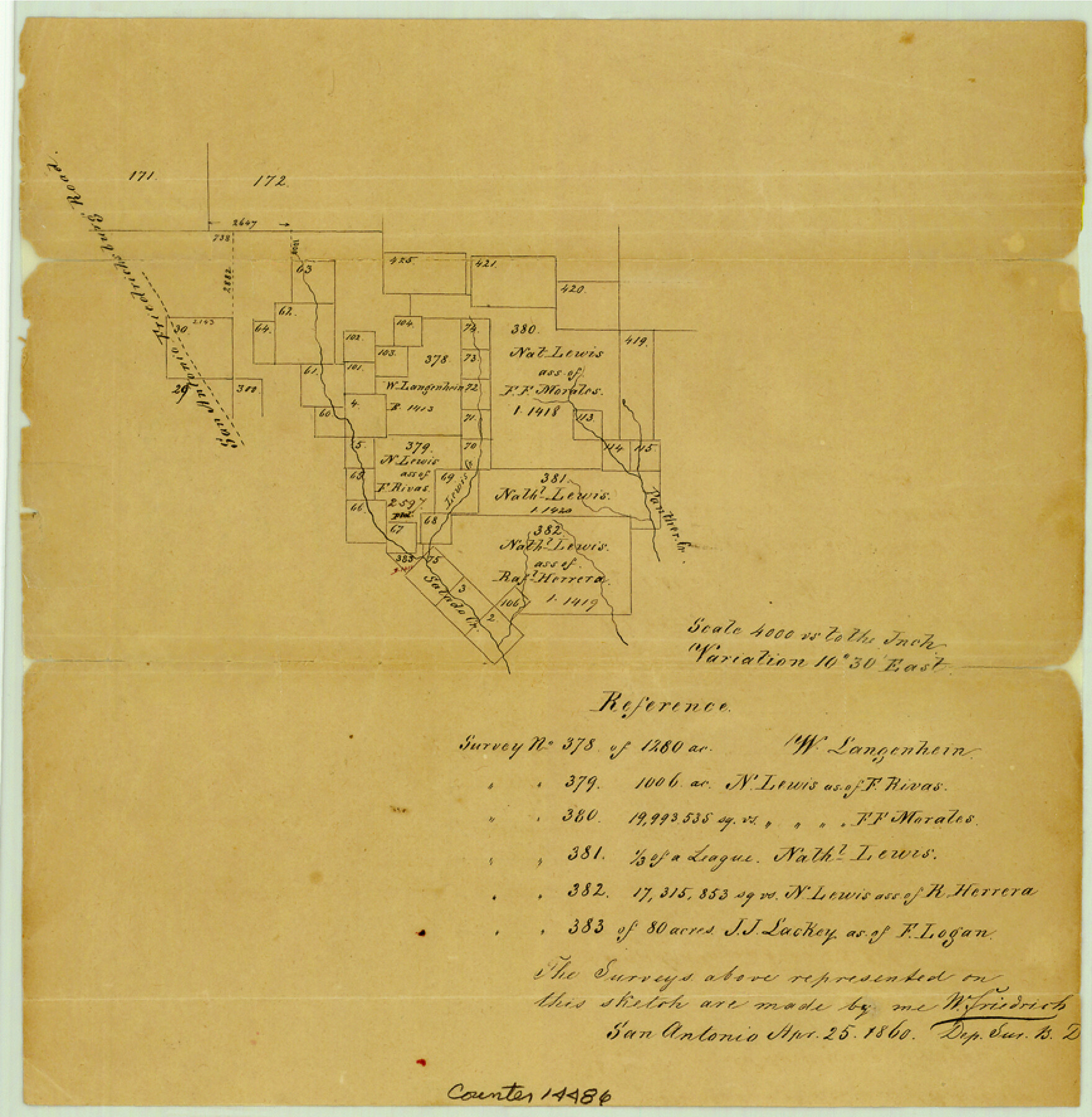
Bexar County Sketch File 25
[Sketch of surveys near Salado, Lewis, and Panther Creeks]
-
Map/Doc
14486
-
Collection
General Map Collection
-
Object Dates
1860/4/25 (Creation Date)
1860/5/2 (File Date)
-
People and Organizations
W. Friedrich (Surveyor/Engineer)
-
Counties
Bexar
-
Subjects
Surveying Sketch File
-
Height x Width
8.9 x 8.7 inches
22.6 x 22.1 cm
-
Medium
paper, manuscript
-
Scale
1" = 4000 varas
-
Features
San Antonio Fredericksburg Road
San Antonio Road
Fredericksburg Road
Panther Creek
Lewis Creek
Salado Creek
Part of: General Map Collection
Maps of Gulf Intracoastal Waterway, Texas - Sabine River to the Rio Grande and connecting waterways including ship channels

Print $20.00
- Digital $50.00
Maps of Gulf Intracoastal Waterway, Texas - Sabine River to the Rio Grande and connecting waterways including ship channels
1966
Size 14.6 x 22.3 inches
Map/Doc 61925
Roberts County Boundary File 2

Print $12.00
- Digital $50.00
Roberts County Boundary File 2
Size 9.9 x 6.4 inches
Map/Doc 58333
University Lands Blocks 29-33, Crockett County, Texas

Print $20.00
- Digital $50.00
University Lands Blocks 29-33, Crockett County, Texas
Size 29.7 x 44.1 inches
Map/Doc 62943
Current Miscellaneous File 69

Print $10.00
- Digital $50.00
Current Miscellaneous File 69
1916
Size 11.2 x 8.8 inches
Map/Doc 74145
Flight Mission No. CRK-5P, Frame 154, Refugio County

Print $20.00
- Digital $50.00
Flight Mission No. CRK-5P, Frame 154, Refugio County
1956
Size 18.6 x 22.5 inches
Map/Doc 86935
Current Miscellaneous File 72

Print $40.00
- Digital $50.00
Current Miscellaneous File 72
Size 10.8 x 8.2 inches
Map/Doc 74159
Current Miscellaneous File 106

Print $36.00
- Digital $50.00
Current Miscellaneous File 106
Size 8.6 x 11.3 inches
Map/Doc 74689
Smith County Working Sketch 5

Print $20.00
- Digital $50.00
Smith County Working Sketch 5
1932
Size 32.2 x 22.4 inches
Map/Doc 63890
Travis County Sketch File 47

Print $6.00
- Digital $50.00
Travis County Sketch File 47
1939
Size 14.3 x 8.9 inches
Map/Doc 38374
Van Zandt County Sketch File 38

Print $4.00
- Digital $50.00
Van Zandt County Sketch File 38
1871
Size 8.2 x 10.1 inches
Map/Doc 39482
Flight Mission No. CGI-3N, Frame 181, Cameron County

Print $20.00
- Digital $50.00
Flight Mission No. CGI-3N, Frame 181, Cameron County
1954
Size 18.5 x 22.2 inches
Map/Doc 84645

You may also like

Johnson County Working Sketch 13

Print $20.00
- Digital $50.00
Johnson County Working Sketch 13
1969
Size 32.0 x 41.0 inches
Map/Doc 66626
Jackson County Sketch File A2 (1)

Print $20.00
- Digital $50.00
Jackson County Sketch File A2 (1)
1899
Size 18.2 x 22.5 inches
Map/Doc 11848
University Lands Hudspeth County, Texas, Blocks A to N

Print $40.00
- Digital $50.00
University Lands Hudspeth County, Texas, Blocks A to N
Size 38.9 x 55.2 inches
Map/Doc 62952
Potter County Boundary File 4a

Print $80.00
- Digital $50.00
Potter County Boundary File 4a
Size 15.2 x 99.1 inches
Map/Doc 58011
Winkler County Working Sketch 12

Print $40.00
- Digital $50.00
Winkler County Working Sketch 12
1961
Size 59.3 x 50.0 inches
Map/Doc 72606
Hopkins County Sketch File 8

Print $6.00
- Digital $50.00
Hopkins County Sketch File 8
1856
Size 11.8 x 8.6 inches
Map/Doc 26695
Map of the City of San Antonio, Bexar County, Texas including suburbs, north and south

Print $20.00
- Digital $50.00
Map of the City of San Antonio, Bexar County, Texas including suburbs, north and south
Size 39.6 x 26.6 inches
Map/Doc 96511
Schleicher County Working Sketch 8

Print $20.00
- Digital $50.00
Schleicher County Working Sketch 8
1923
Size 21.6 x 18.6 inches
Map/Doc 63810
Red River County Working Sketch 60

Print $20.00
- Digital $50.00
Red River County Working Sketch 60
1973
Size 27.1 x 40.0 inches
Map/Doc 72043
Texas Coast Showing Points of Occupation of Expedition Under Maj. Gen. N.P. Banks, Novr. 1863

Print $20.00
Texas Coast Showing Points of Occupation of Expedition Under Maj. Gen. N.P. Banks, Novr. 1863
1863
Size 16.0 x 17.1 inches
Map/Doc 88593
Sutton County Sketch File 44

Print $6.00
- Digital $50.00
Sutton County Sketch File 44
1939
Size 11.3 x 8.7 inches
Map/Doc 37512