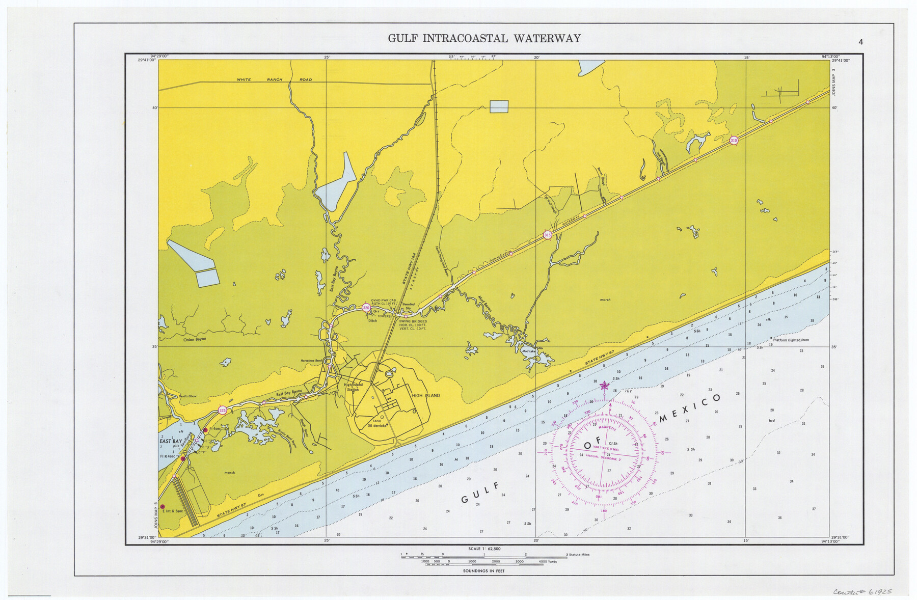
Maps of Gulf Intracoastal Waterway, Texas - Sabine River to the Rio Grande and connecting waterways including ship channels
-
Map/Doc
61925
-
Collection
General Map Collection
-
Object Dates
1966 (Creation Date)
-
Subjects
Intracoastal Waterways
-
Height x Width
14.6 x 22.3 inches
37.1 x 56.6 cm
Part of: General Map Collection
Flight Mission No. BRE-1P, Frame 116, Nueces County

Print $20.00
- Digital $50.00
Flight Mission No. BRE-1P, Frame 116, Nueces County
1956
Size 18.6 x 22.5 inches
Map/Doc 86682
Winkler County

Print $20.00
- Digital $50.00
Winkler County
1932
Size 39.7 x 38.5 inches
Map/Doc 95678
Fayette County Sketch File 4

Print $4.00
- Digital $50.00
Fayette County Sketch File 4
Size 11.7 x 7.9 inches
Map/Doc 22504
Flight Mission No. BRA-16M, Frame 74, Jefferson County

Print $20.00
- Digital $50.00
Flight Mission No. BRA-16M, Frame 74, Jefferson County
1953
Size 18.6 x 22.5 inches
Map/Doc 85691
Flight Mission No. BRA-7M, Frame 198, Jefferson County

Print $20.00
- Digital $50.00
Flight Mission No. BRA-7M, Frame 198, Jefferson County
1953
Size 18.7 x 22.4 inches
Map/Doc 85566
Harris County Rolled Sketch T2

Print $20.00
- Digital $50.00
Harris County Rolled Sketch T2
1916
Size 26.8 x 23.2 inches
Map/Doc 6145
Presidio County Rolled Sketch 26

Print $20.00
- Digital $50.00
Presidio County Rolled Sketch 26
1886
Size 33.9 x 26.9 inches
Map/Doc 7333
Harris County Rolled Sketch R & B

Print $40.00
- Digital $50.00
Harris County Rolled Sketch R & B
1901
Size 27.9 x 60.6 inches
Map/Doc 8344
Map of Armstrong County

Print $20.00
- Digital $50.00
Map of Armstrong County
1881
Size 25.8 x 19.9 inches
Map/Doc 3243
West Houston: Hwy. 6 from Spencer Rd. in the North to South of Sugar Land. From Wilcrest Dr. in the East to and including Katy.

West Houston: Hwy. 6 from Spencer Rd. in the North to South of Sugar Land. From Wilcrest Dr. in the East to and including Katy.
Size 35.4 x 22.7 inches
Map/Doc 94336
Map of Denton County

Print $20.00
- Digital $50.00
Map of Denton County
1897
Size 43.4 x 40.2 inches
Map/Doc 4720
Wise County Working Sketch 6

Print $20.00
- Digital $50.00
Wise County Working Sketch 6
1950
Size 12.0 x 15.2 inches
Map/Doc 72620
You may also like
Map of Maverick County

Print $20.00
- Digital $50.00
Map of Maverick County
1878
Size 33.4 x 20.6 inches
Map/Doc 3850
Nueces County NRC Article 33.136 Sketch 3

Print $68.00
- Digital $50.00
Nueces County NRC Article 33.136 Sketch 3
2002
Size 24.7 x 36.5 inches
Map/Doc 87922
Newton County Working Sketch 32

Print $20.00
- Digital $50.00
Newton County Working Sketch 32
1955
Size 22.9 x 24.0 inches
Map/Doc 71278
The Republic County of Robertson. January 30, 1841

Print $20.00
The Republic County of Robertson. January 30, 1841
2020
Size 16.9 x 21.7 inches
Map/Doc 96261
Hemphill County

Print $20.00
- Digital $50.00
Hemphill County
1899
Size 42.2 x 34.1 inches
Map/Doc 4682
Crane County Rolled Sketch 25

Print $20.00
- Digital $50.00
Crane County Rolled Sketch 25
2019
Size 36.2 x 23.8 inches
Map/Doc 95746
Archer County Working Sketch 17

Print $3.00
- Digital $50.00
Archer County Working Sketch 17
1951
Size 10.7 x 12.2 inches
Map/Doc 67158
The Rand McNally New Commercial Atlas Map of Texas

Print $20.00
- Digital $50.00
The Rand McNally New Commercial Atlas Map of Texas
1919
Size 28.4 x 40.2 inches
Map/Doc 95852
Henderson County Working Sketch 13

Print $20.00
- Digital $50.00
Henderson County Working Sketch 13
1918
Size 23.2 x 24.7 inches
Map/Doc 66146
Crosby County Sketch File 36

Print $4.00
- Digital $50.00
Crosby County Sketch File 36
1935
Size 7.5 x 9.2 inches
Map/Doc 20108
Aransas County Sketch File 32

Print $12.00
- Digital $50.00
Aransas County Sketch File 32
1919
Size 14.2 x 9.0 inches
Map/Doc 13297
Cochran County, Texas

Print $20.00
- Digital $50.00
Cochran County, Texas
Size 29.8 x 37.5 inches
Map/Doc 92492