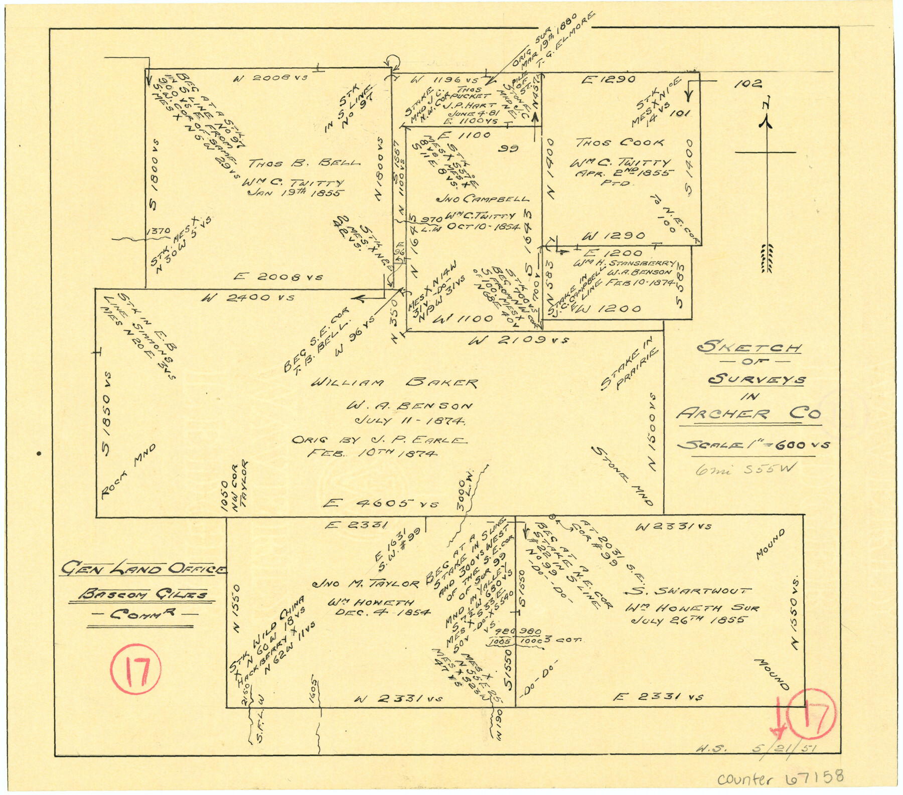
Archer County Working Sketch 17
-
Map/Doc
67158
-
Collection
General Map Collection
-
Object Dates
5/21/1951 (Creation Date)
-
People and Organizations
William Shirriffs (Draftsman)
Bascom Giles (GLO Commissioner)
-
Counties
Archer
-
Subjects
Surveying Working Sketch
-
Height x Width
10.7 x 12.2 inches
27.2 x 31.0 cm
-
Scale
1" = 600 varas
-
Comments
Surveys located about six miles South 55 degrees West of Archer City, Texas.
Part of: General Map Collection
Territorios de Sierragorda e Isla del Carmen

Print $20.00
- Digital $50.00
Territorios de Sierragorda e Isla del Carmen
Size 22.9 x 31.2 inches
Map/Doc 97011
Bosque County Working Sketch 33

Print $20.00
- Digital $50.00
Bosque County Working Sketch 33
2016
Size 37.0 x 25.0 inches
Map/Doc 93980
Flight Mission No. BRE-1P, Frame 149, Nueces County

Print $20.00
- Digital $50.00
Flight Mission No. BRE-1P, Frame 149, Nueces County
1956
Size 18.3 x 22.3 inches
Map/Doc 86709

Navarro County Working Sketch 1b

Print $20.00
- Digital $50.00
Navarro County Working Sketch 1b
Size 32.5 x 44.6 inches
Map/Doc 71230
Anderson County Sketch File 1

Print $4.00
- Digital $50.00
Anderson County Sketch File 1
1845
Size 12.5 x 8.3 inches
Map/Doc 12737
Calhoun County Rolled Sketch 29C

Print $20.00
- Digital $50.00
Calhoun County Rolled Sketch 29C
1977
Size 22.0 x 24.0 inches
Map/Doc 8559
Ward County Working Sketch 22

Print $20.00
- Digital $50.00
Ward County Working Sketch 22
1953
Size 19.5 x 20.7 inches
Map/Doc 72328
Flight Mission No. DAG-24K, Frame 45, Matagorda County

Print $20.00
- Digital $50.00
Flight Mission No. DAG-24K, Frame 45, Matagorda County
1953
Size 18.6 x 22.2 inches
Map/Doc 86532
Galveston County Sketch File 55

Print $20.00
- Digital $50.00
Galveston County Sketch File 55
1839
Size 5.2 x 3.7 inches
Map/Doc 23591
Crockett County Rolled Sketch 66

Print $20.00
- Digital $50.00
Crockett County Rolled Sketch 66
1947
Size 22.4 x 23.3 inches
Map/Doc 5609
Edwards County Rolled Sketch 27

Print $20.00
- Digital $50.00
Edwards County Rolled Sketch 27
1959
Size 18.0 x 33.2 inches
Map/Doc 5813
You may also like
Hays County Rolled Sketch 26

Print $20.00
- Digital $50.00
Hays County Rolled Sketch 26
1943
Size 27.7 x 25.6 inches
Map/Doc 6182
[Sketch for Mineral Application 16787 - Pecos River Bed, A. T. Freet]
![2815, [Sketch for Mineral Application 16787 - Pecos River Bed, A. T. Freet], General Map Collection](https://historictexasmaps.com/wmedia_w700/maps/2815-1.tif.jpg)
Print $20.00
- Digital $50.00
[Sketch for Mineral Application 16787 - Pecos River Bed, A. T. Freet]
1927
Size 20.0 x 46.7 inches
Map/Doc 2815
Burnet County Rolled Sketch 6

Print $40.00
- Digital $50.00
Burnet County Rolled Sketch 6
1971
Size 36.4 x 49.5 inches
Map/Doc 8543
Karnes County Sketch File 15

Print $28.00
- Digital $50.00
Karnes County Sketch File 15
1922
Size 11.4 x 8.8 inches
Map/Doc 28618
Upton County Rolled Sketch 33

Print $20.00
- Digital $50.00
Upton County Rolled Sketch 33
1951
Size 39.2 x 33.0 inches
Map/Doc 8076
Swisher County Working Sketch 5

Print $20.00
- Digital $50.00
Swisher County Working Sketch 5
1973
Size 16.0 x 26.5 inches
Map/Doc 62416
[Sketch showing details along East line of Lipscomb County]
![89939, [Sketch showing details along East line of Lipscomb County], Twichell Survey Records](https://historictexasmaps.com/wmedia_w700/maps/89939-1.tif.jpg)
Print $40.00
- Digital $50.00
[Sketch showing details along East line of Lipscomb County]
Size 15.4 x 66.7 inches
Map/Doc 89939
Flight Mission No. CGI-3N, Frame 160, Cameron County

Print $20.00
- Digital $50.00
Flight Mission No. CGI-3N, Frame 160, Cameron County
1954
Size 18.5 x 22.3 inches
Map/Doc 84624
[Sketch showing University Lands in West Texas]
![62964, [Sketch showing University Lands in West Texas], General Map Collection](https://historictexasmaps.com/wmedia_w700/maps/62964-1.tif.jpg)
Print $20.00
- Digital $50.00
[Sketch showing University Lands in West Texas]
Size 20.5 x 27.8 inches
Map/Doc 62964
McLaughlin Farm, Crosby County, Texas

Print $20.00
- Digital $50.00
McLaughlin Farm, Crosby County, Texas
1952
Size 14.3 x 14.1 inches
Map/Doc 92615
Orange County Working Sketch 52

Print $20.00
- Digital $50.00
Orange County Working Sketch 52
2006
Size 31.9 x 47.5 inches
Map/Doc 83069
The Mexican Municipality of Colorado. Created, January 11, 1836

Print $20.00
The Mexican Municipality of Colorado. Created, January 11, 1836
2020
Size 15.7 x 21.6 inches
Map/Doc 96019