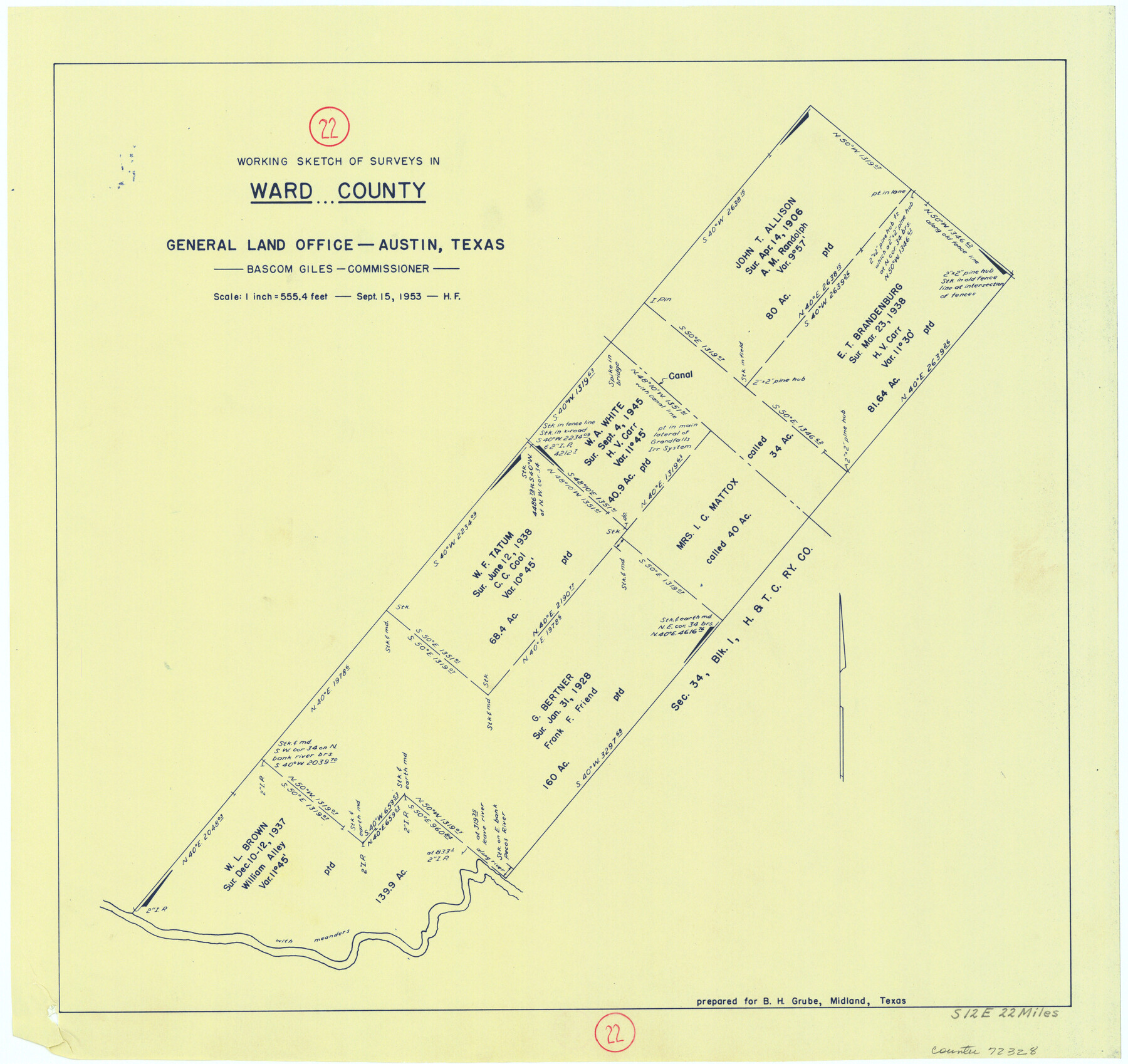
Ward County Working Sketch 22
- 
                          Map/Doc
72328
 - 
                            Collection
General Map Collection
 - 
                            Object Dates
9/15/1953 (Creation Date)
 - 
                            People and Organizations
Herman Forbes (Draftsman)
 - 
                            Counties
Ward
 - 
                            Subjects
Surveying Working Sketch
 - 
                            Height x Width
19.5 x 20.7 inches
49.5 x 52.6 cm
 - 
                            Scale
1" = 555.4 feet
 
Part of: General Map Collection
            Rio Grande, Hidalgo Sheet


                                            Print $20.00                    
                                             -                         Digital $50.00                                    
                Rio Grande, Hidalgo Sheet
1937
Size 36.8 x 36.8 inches
                                Map/Doc 65122
            
            Hartley County Rolled Sketch 2


                                            Print $20.00                    
                                             -                         Digital $50.00                                    
                Hartley County Rolled Sketch 2
Size 41.2 x 27.6 inches
                                Map/Doc 6158
            
            [Sketch in DeWitt County]


                                            Print $3.00                    
                                             -                         Digital $50.00                                    
                [Sketch in DeWitt County]
Size 9.3 x 10.1 inches
                                Map/Doc 78383
            
            Coast Chart No. 210 Aransas Pass and Corpus Christi Bay with the coast to latitude 27° 12' Texas


                                            Print $20.00                    
                                             -                         Digital $50.00                                    
                Coast Chart No. 210 Aransas Pass and Corpus Christi Bay with the coast to latitude 27° 12' Texas
1887
Size 27.5 x 18.2 inches
                                Map/Doc 72812
            
            [Surveys in Austin's Colony along the San Bernardo River from the mouth of Peach Creek]


                                            Print $20.00                    
                                             -                         Digital $50.00                                    
                [Surveys in Austin's Colony along the San Bernardo River from the mouth of Peach Creek]
1821
Size 23.4 x 10.6 inches
                                Map/Doc 209
            
            Map and Profile No. 1 from the Red River to the Rio Grande; from explorations and surveys made under the direction of the Hon. Jefferson Davis, Secretary of War by Captain John Pope, Corps. Topl Engrs.


                                            Print $40.00                    
                                             -                         Digital $50.00                                    
                Map and Profile No. 1 from the Red River to the Rio Grande; from explorations and surveys made under the direction of the Hon. Jefferson Davis, Secretary of War by Captain John Pope, Corps. Topl Engrs.
Size 30.2 x 59.9 inches
                                Map/Doc 95176
            
            Hunt County Rolled Sketch 5


                                            Print $20.00                    
                                             -                         Digital $50.00                                    
                Hunt County Rolled Sketch 5
1956
Size 22.9 x 23.0 inches
                                Map/Doc 6272
            
            Goliad County Sketch File 19


                                            Print $10.00                    
                                             -                         Digital $50.00                                    
                Goliad County Sketch File 19
Size 12.9 x 8.0 inches
                                Map/Doc 24260
            
            Flight Mission No. CRC-4R, Frame 106, Chambers County


                                            Print $20.00                    
                                             -                         Digital $50.00                                    
                Flight Mission No. CRC-4R, Frame 106, Chambers County
1956
Size 18.6 x 22.3 inches
                                Map/Doc 84903
            
            Sterling County Sketch File 13


                                            Print $20.00                    
                                             -                         Digital $50.00                                    
                Sterling County Sketch File 13
Size 26.1 x 19.4 inches
                                Map/Doc 12359
            
            Houston & Texas Central


                                            Print $40.00                    
                                             -                         Digital $50.00                                    
                Houston & Texas Central
Size 24.1 x 56.4 inches
                                Map/Doc 64797
            You may also like
            Jasper County Sketch File 12


                                            Print $4.00                    
                                             -                         Digital $50.00                                    
                Jasper County Sketch File 12
Size 8.8 x 10.0 inches
                                Map/Doc 27792
            
            Brewster County Sketch File N-19


                                            Print $40.00                    
                                             -                         Digital $50.00                                    
                Brewster County Sketch File N-19
1946
Size 18.7 x 26.2 inches
                                Map/Doc 10966
            
            Burleson County Working Sketch 25


                                            Print $20.00                    
                                             -                         Digital $50.00                                    
                Burleson County Working Sketch 25
1981
Size 27.9 x 31.0 inches
                                Map/Doc 67744
            
            Flight Mission No. BRE-1P, Frame 80, Nueces County


                                            Print $20.00                    
                                             -                         Digital $50.00                                    
                Flight Mission No. BRE-1P, Frame 80, Nueces County
1956
Size 18.4 x 22.3 inches
                                Map/Doc 86662
            
            Wilson County Boundary File 3


                                            Print $26.00                    
                                             -                         Digital $50.00                                    
                Wilson County Boundary File 3
Size 14.3 x 8.7 inches
                                Map/Doc 60083
            
            Palo Pinto County Working Sketch 3


                                            Print $20.00                    
                                             -                         Digital $50.00                                    
                Palo Pinto County Working Sketch 3
1906
Map/Doc 71386
            
            The Republic County of Washington. January 15, 1842


                                            Print $20.00                    
                                    
                The Republic County of Washington. January 15, 1842
2020
Size 11.8 x 21.7 inches
                                Map/Doc 96306
            
            Reagan County Rolled Sketch 16


                                            Print $20.00                    
                                             -                         Digital $50.00                                    
                Reagan County Rolled Sketch 16
Size 25.6 x 47.5 inches
                                Map/Doc 9811
            
            Clay County Rolled Sketch 4A


                                            Print $20.00                    
                                             -                         Digital $50.00                                    
                Clay County Rolled Sketch 4A
1949
Size 22.0 x 24.0 inches
                                Map/Doc 5498
            
            Flight Mission No. DCL-7C, Frame 61, Kenedy County


                                            Print $20.00                    
                                             -                         Digital $50.00                                    
                Flight Mission No. DCL-7C, Frame 61, Kenedy County
1943
Size 15.4 x 15.2 inches
                                Map/Doc 86049
            
            Jeff Davis County Rolled Sketch 6A


                                            Print $20.00                    
                                             -                         Digital $50.00                                    
                Jeff Davis County Rolled Sketch 6A
1889
Size 20.1 x 40.4 inches
                                Map/Doc 6361
            
            [Sketch for Mineral Application 27670 - Strip between Simon Sanchez leagues and Trinity River]


                                            Print $40.00                    
                                             -                         Digital $50.00                                    
                [Sketch for Mineral Application 27670 - Strip between Simon Sanchez leagues and Trinity River]
Size 55.5 x 17.8 inches
                                Map/Doc 65646