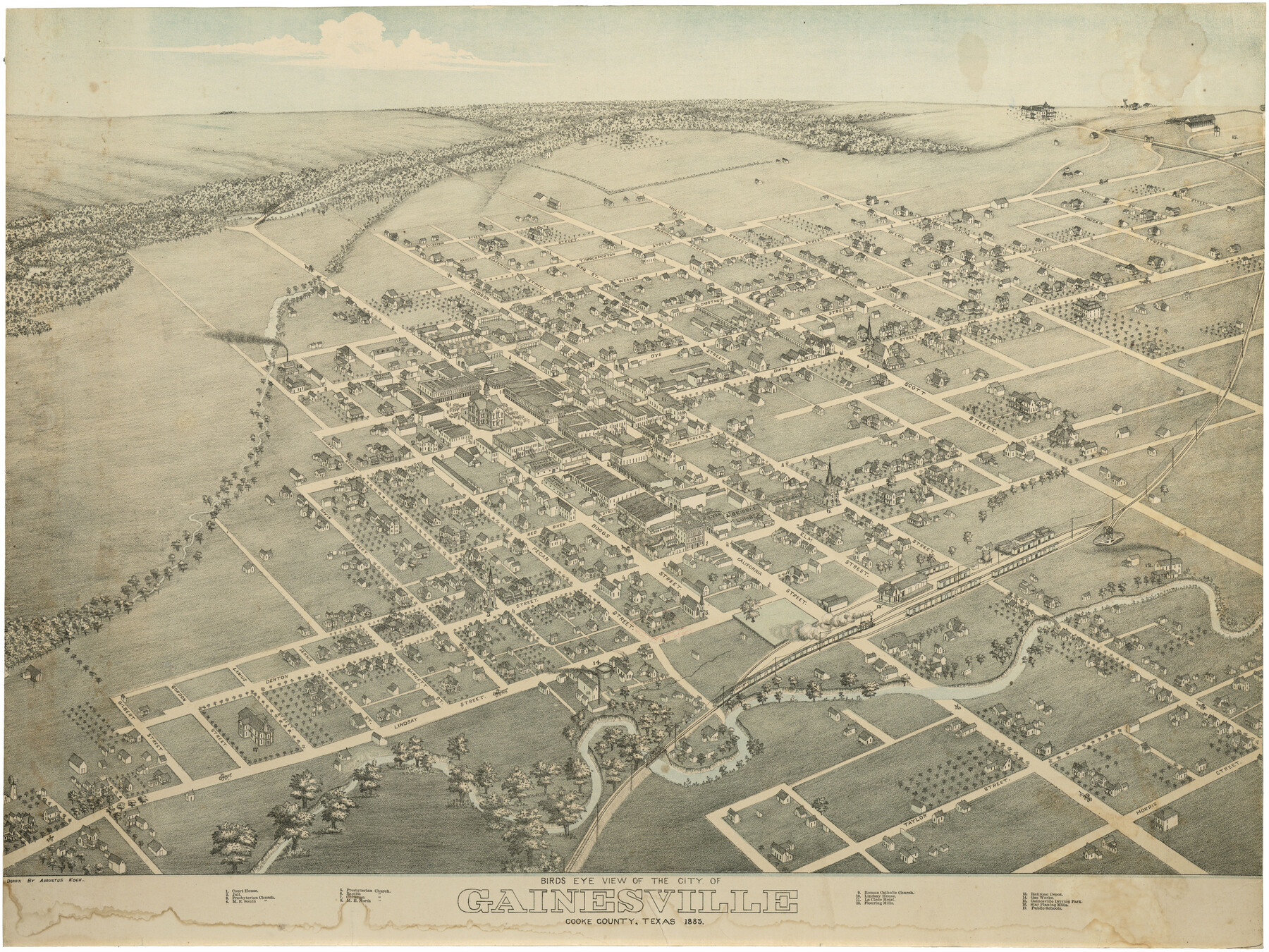
Bird's Eye View of the City of Gainesville Cooke County, Texas
-
Map/Doc
89084
-
Collection
Non-GLO Digital Images
-
Object Dates
1883 (Creation Date)
-
People and Organizations
Augustus Koch (Draftsman)
-
Counties
Cooke
-
Subjects
Bird's Eye View City Pictorial
-
Height x Width
19.2 x 25.6 inches
48.8 x 65.0 cm
-
Comments
Bird's Eye View map. Public Domain image obtained from Wikimedia Commons.
Part of: Non-GLO Digital Images
Plano del Presidio de Nra Senora del Pilar de los Adaes

Plano del Presidio de Nra Senora del Pilar de los Adaes
1766
Size 7.3 x 9.2 inches
Map/Doc 96517
Bird's Eye View of the City of Gainesville Cooke County, Texas

Print $20.00
Bird's Eye View of the City of Gainesville Cooke County, Texas
1883
Size 19.2 x 25.6 inches
Map/Doc 89084
Bird's Eye View of Corpus Christi

Print $20.00
Bird's Eye View of Corpus Christi
1887
Size 21.4 x 28.0 inches
Map/Doc 94113
A New Chart of the World on Mercator's Projection: Exhibiting the Tracks & Discoveries of the most Eminent Navigators, to the Present Period

Print $20.00
- Digital $50.00
A New Chart of the World on Mercator's Projection: Exhibiting the Tracks & Discoveries of the most Eminent Navigators, to the Present Period
1801
Size 20.0 x 22.4 inches
Map/Doc 97249

Amérique Septentrionale

Print $20.00
Amérique Septentrionale
1845
Size 13.8 x 20.3 inches
Map/Doc 94571
Bird's Eye View of San Marcos, Hays County, Texas

Print $20.00
Bird's Eye View of San Marcos, Hays County, Texas
1881
Size 18.5 x 28.3 inches
Map/Doc 89205
Bird's Eye View of Gatesville, Coryell County, Texas

Print $20.00
Bird's Eye View of Gatesville, Coryell County, Texas
1884
Size 15.7 x 24.2 inches
Map/Doc 89088
Austin, State Capital of Texas

Print $20.00
Austin, State Capital of Texas
1887
Size 27.5 x 40.0 inches
Map/Doc 89218
Descripción y Mapa de la Nueva Provincia, poblada de Bárbaros, situada en la Costa del Seno Mexicano, desde el puerto de Tampico hasta la Provincia de Texas

Descripción y Mapa de la Nueva Provincia, poblada de Bárbaros, situada en la Costa del Seno Mexicano, desde el puerto de Tampico hasta la Provincia de Texas
1744
Size 32.0 x 29.1 inches
Map/Doc 94558
[Movements & Objectives of the 143rd & 144th Infantry on October 9-11, 1918, Appendix E, Nos.2 and 3] - Verso
![94132, [Movements & Objectives of the 143rd & 144th Infantry on October 9-11, 1918, Appendix E, Nos.2 and 3] - Verso, Non-GLO Digital Images](https://historictexasmaps.com/wmedia_w700/maps/94132-1.tif.jpg)
Print $20.00
[Movements & Objectives of the 143rd & 144th Infantry on October 9-11, 1918, Appendix E, Nos.2 and 3] - Verso
1918
Size 41.9 x 20.2 inches
Map/Doc 94132
Carta geográfica que comprende en su extensión mucha parte del arzobispado de México, y alguna de los obispados de Puebla, Valladolid de Michoacán, Guadalajara y Durango, confinantes entre si

Carta geográfica que comprende en su extensión mucha parte del arzobispado de México, y alguna de los obispados de Puebla, Valladolid de Michoacán, Guadalajara y Durango, confinantes entre si
1779
Size 33.9 x 22.0 inches
Map/Doc 97079
You may also like
Presidio County Rolled Sketch 47

Print $20.00
- Digital $50.00
Presidio County Rolled Sketch 47
1908
Size 30.8 x 32.2 inches
Map/Doc 7343
[Capitol Leagues along New Mexico Line]
![90766, [Capitol Leagues along New Mexico Line], Twichell Survey Records](https://historictexasmaps.com/wmedia_w700/maps/90766-1.tif.jpg)
Print $20.00
- Digital $50.00
[Capitol Leagues along New Mexico Line]
Size 8.2 x 22.7 inches
Map/Doc 90766
Presidio County Working Sketch 103

Print $20.00
- Digital $50.00
Presidio County Working Sketch 103
1980
Size 47.8 x 31.2 inches
Map/Doc 71780
Foard County Sketch File 15

Print $8.00
- Digital $50.00
Foard County Sketch File 15
1883
Size 13.0 x 8.5 inches
Map/Doc 22821
Hays County Rolled Sketch 20

Print $20.00
- Digital $50.00
Hays County Rolled Sketch 20
Size 14.1 x 36.9 inches
Map/Doc 6176
Rusk County Working Sketch 32

Print $20.00
- Digital $50.00
Rusk County Working Sketch 32
1919
Size 16.7 x 17.1 inches
Map/Doc 63669
Brewster County Rolled Sketch 158

Print $20.00
- Digital $50.00
Brewster County Rolled Sketch 158
2007
Size 24.6 x 36.5 inches
Map/Doc 89623
Palo Pinto County Rolled Sketch 10

Print $20.00
- Digital $50.00
Palo Pinto County Rolled Sketch 10
1954
Size 35.4 x 34.1 inches
Map/Doc 9676
Jack County Sketch File 10

Print $4.00
- Digital $50.00
Jack County Sketch File 10
1857
Size 12.4 x 8.3 inches
Map/Doc 27527

Reeves County

Print $20.00
- Digital $50.00
Reeves County
1903
Size 47.3 x 35.6 inches
Map/Doc 66997
Copy of Surveyor's Field Book, Morris Browning - In Blocks 7, 5 & 4, I&GNRRCo., Hutchinson and Carson Counties, Texas

Print $2.00
- Digital $50.00
Copy of Surveyor's Field Book, Morris Browning - In Blocks 7, 5 & 4, I&GNRRCo., Hutchinson and Carson Counties, Texas
1888
Size 6.8 x 8.8 inches
Map/Doc 62274