Hudspeth County Sketch File 28
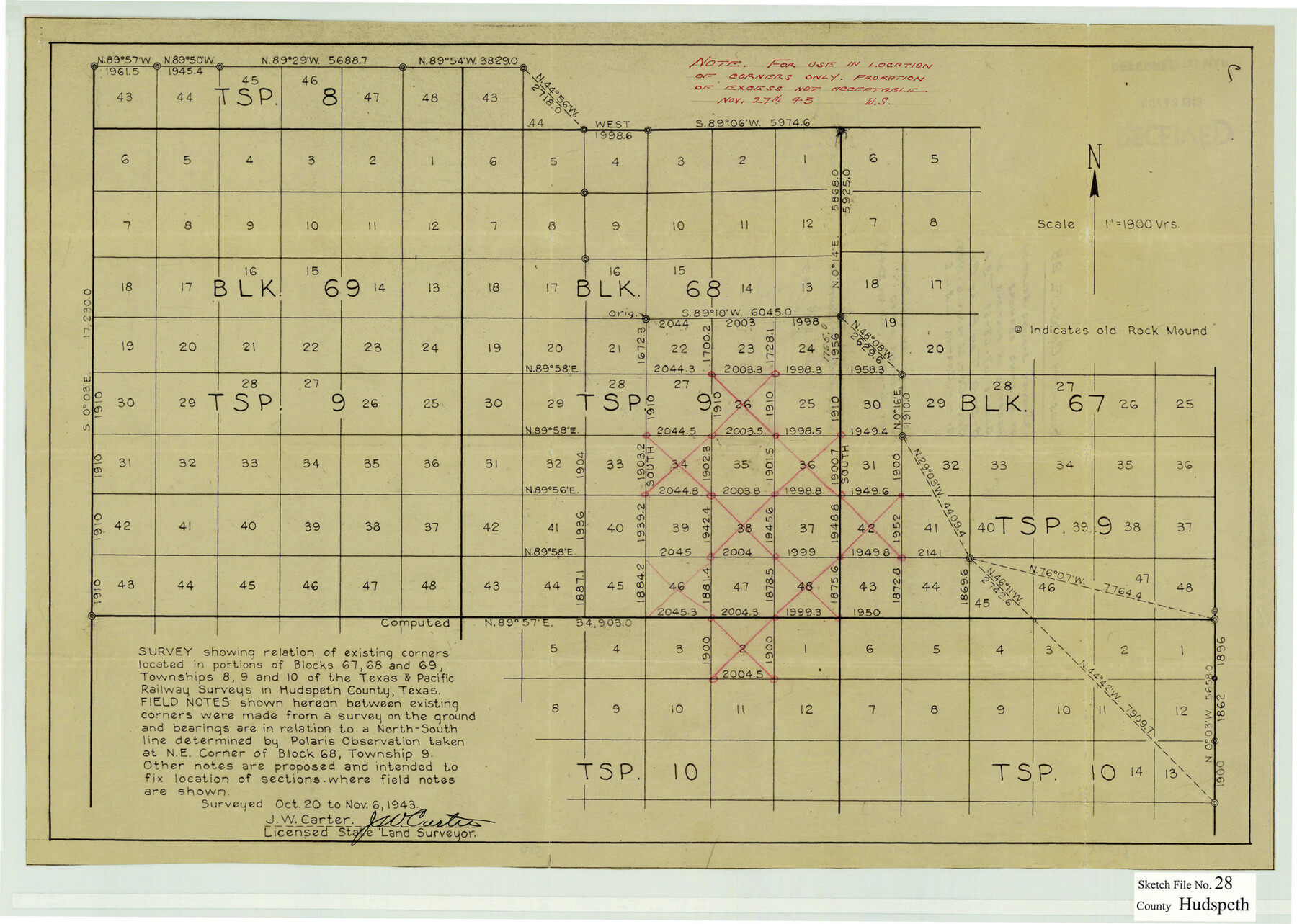
Survey showing relation of existing corners located in portions of Blocks 67-68-69 T.S.P. 8-9-10 T and P. Ry. Co.
-
Map/Doc
11803
-
Collection
General Map Collection
-
Object Dates
11/6/1943 (Creation Date)
11/27/1943 (File Date)
10/20/1943 (Survey Date)
11/6/1943 (Survey Date)
-
People and Organizations
J.W. Carter (Surveyor/Engineer)
-
Counties
Hudspeth
-
Subjects
Surveying Sketch File
-
Height x Width
15.3 x 21.4 inches
38.9 x 54.4 cm
-
Medium
paper, manuscript
-
Scale
1" = 1900 varas
Part of: General Map Collection
Grayson County Rolled Sketch 3

Print $20.00
- Digital $50.00
Grayson County Rolled Sketch 3
1952
Size 33.7 x 46.1 inches
Map/Doc 9666
Isogonic Chart and Meridian Changes, University Land, Hudspeth County, Texas

Print $20.00
- Digital $50.00
Isogonic Chart and Meridian Changes, University Land, Hudspeth County, Texas
Size 28.5 x 34.1 inches
Map/Doc 62953
San Augustine County Working Sketch 14

Print $20.00
- Digital $50.00
San Augustine County Working Sketch 14
1958
Size 22.7 x 26.1 inches
Map/Doc 63702
Wheeler County Rolled Sketch 3

Print $20.00
- Digital $50.00
Wheeler County Rolled Sketch 3
Size 31.9 x 21.9 inches
Map/Doc 8239
Flight Mission No. DIX-5P, Frame 138, Aransas County

Print $20.00
- Digital $50.00
Flight Mission No. DIX-5P, Frame 138, Aransas County
1956
Size 17.7 x 17.9 inches
Map/Doc 83799
Smith County Rolled Sketch 6A3

Print $40.00
- Digital $50.00
Smith County Rolled Sketch 6A3
1990
Size 48.6 x 36.8 inches
Map/Doc 10698
Texas City Channel, Texas, Channel and Turning Basin Dredging - Sheet 2

Print $20.00
- Digital $50.00
Texas City Channel, Texas, Channel and Turning Basin Dredging - Sheet 2
1958
Size 28.6 x 41.0 inches
Map/Doc 61832
Webb County Rolled Sketch 50

Print $20.00
- Digital $50.00
Webb County Rolled Sketch 50
1943
Size 38.2 x 42.6 inches
Map/Doc 10125
Flight Mission No. DQO-3K, Frame 21, Galveston County

Print $20.00
- Digital $50.00
Flight Mission No. DQO-3K, Frame 21, Galveston County
1952
Size 18.9 x 22.5 inches
Map/Doc 85062
Caldwell County Working Sketch 8

Print $20.00
- Digital $50.00
Caldwell County Working Sketch 8
1964
Size 29.1 x 22.8 inches
Map/Doc 67838
Henderson County Working Sketch 5

Print $20.00
- Digital $50.00
Henderson County Working Sketch 5
1918
Size 19.2 x 23.5 inches
Map/Doc 66138
Rockwall County

Print $20.00
- Digital $50.00
Rockwall County
1941
Size 28.7 x 23.0 inches
Map/Doc 73277
You may also like

Crane County Working Sketch 18

Print $20.00
- Digital $50.00
Crane County Working Sketch 18
1959
Size 37.9 x 18.8 inches
Map/Doc 68295
Denton County Working Sketch 34

Print $20.00
- Digital $50.00
Denton County Working Sketch 34
2005
Size 22.2 x 27.3 inches
Map/Doc 83570
Bexar County Working Sketch 6

Print $40.00
- Digital $50.00
Bexar County Working Sketch 6
1945
Size 56.4 x 41.2 inches
Map/Doc 67322
Bell County Working Sketch 2

Print $20.00
- Digital $50.00
Bell County Working Sketch 2
1938
Size 25.8 x 28.8 inches
Map/Doc 67342
Blocks T1, T2, T3, S3, A, O5, and Capitol Leagues]
![91074, Blocks T1, T2, T3, S3, A, O5, and Capitol Leagues], Twichell Survey Records](https://historictexasmaps.com/wmedia_w700/maps/91074-1.tif.jpg)
Print $20.00
- Digital $50.00
Blocks T1, T2, T3, S3, A, O5, and Capitol Leagues]
Size 30.0 x 33.4 inches
Map/Doc 91074
Real County Sketch File 3

Print $16.00
- Digital $50.00
Real County Sketch File 3
1906
Size 9.2 x 8.2 inches
Map/Doc 35039
General Highway Map, Burleson County, Texas

Print $20.00
General Highway Map, Burleson County, Texas
1961
Size 18.1 x 24.8 inches
Map/Doc 79391
Map of Clay County

Print $20.00
- Digital $50.00
Map of Clay County
1874
Size 30.3 x 20.1 inches
Map/Doc 3403
Topographical Map of the Rio Grande from Roma to the Gulf of Mexico, Index Map, Sheet No. 2

Print $20.00
- Digital $50.00
Topographical Map of the Rio Grande from Roma to the Gulf of Mexico, Index Map, Sheet No. 2
1912
Map/Doc 89524
Presidio County Working Sketch 23

Print $20.00
- Digital $50.00
Presidio County Working Sketch 23
1945
Size 35.7 x 23.3 inches
Map/Doc 71699
Right of Way and Track Map of The Wichita Falls & Southern Railroad Company

Print $40.00
- Digital $50.00
Right of Way and Track Map of The Wichita Falls & Southern Railroad Company
1942
Size 25.0 x 56.2 inches
Map/Doc 64520