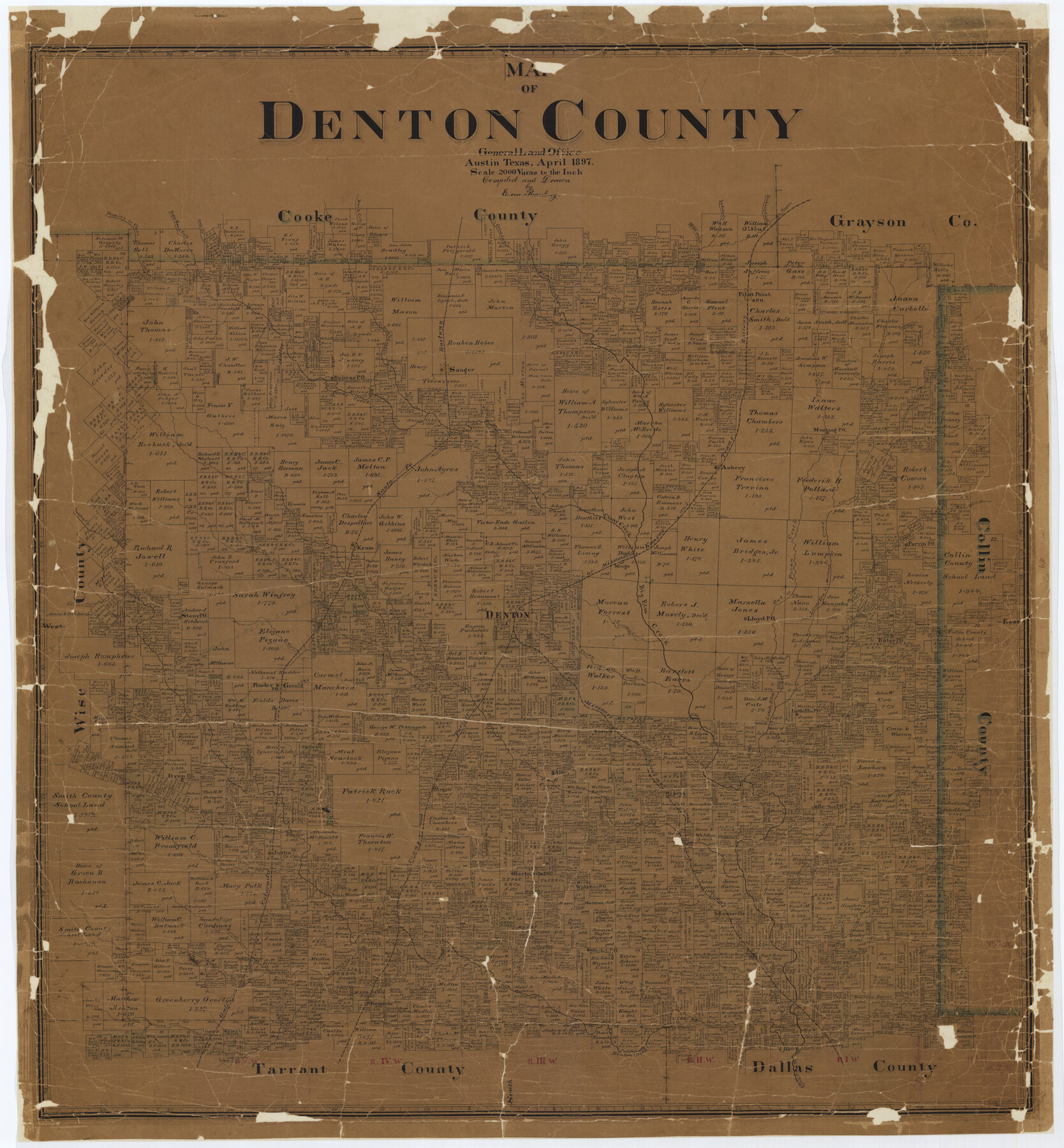
Map of Denton County
-
Map/Doc
4720
-
Collection
General Map Collection
-
Object Dates
1897 (Creation Date)
-
People and Organizations
Texas General Land Office (Publisher)
E. von Rosenberg (Compiler)
E. von Rosenberg (Draftsman)
-
Counties
Denton
-
Subjects
County
-
Height x Width
43.4 x 40.2 inches
110.2 x 102.1 cm
-
Medium
paper, manuscript
-
Comments
Conservation funded in 2002 with donation from John F. Pierce.
-
Features
Hickory Creek
Timber Creek
Stewart's Creek
North Fork of Stewarts Creek
South Fork of Stewarts Creek
Oliver Creek
Cooper's Creek
Does Branch of Little Elm Creek
Panther Creek
Owl Creek
Dry Hickory Creek
North Hickory Creek
Brooks Creek
Little Hickory Creek
South Hickory Creek
Denton Creek
Moors Creek
Does Creek
Little Elm Creek
Herron Branch of Little Elm Creek
Pecan Creek
Mustang Creek
Jordan's Creek
MEP&P
Marshalls Creek
Hoosier Run Creek
Lewisville
Garza
Gerald
Brush Knob
Wolf Creek
Catlett Creek
Dry Hickory Creek
Milam Creek
Indian Creek
Elm Fork of Denton Creek
Cottonwood Branch of Denton Creek
Henrietta Creek
Harriet's Creek
Elizabeth Creek
Maranetts Creek
Pond Creek
Trail Creek
Hog Branch of Denton Creek
Mary Ann Creek
Sanger
Little Elm Post Office
Lloyd Post Office
Shiloh Post Office
Rector Post Office
Drop Post Office
Ponder Post Office
Bartonville Post Office
Waketon Post Office
Stewardsville
Aubrey
Bates Post Office
Mingo
Krum
Justin
Roanoke
Argyle
Denton
Alton
Gorinth
Lewisville
Isle du Bois Creek
Fannin's Creek
Wolf Creek
Walnunt [sic] Creek
Big Elm Creek
Elm Fork of Big Elm Creek
Buck Creek
Spring Creek
Duck Creek
Gray's Creek
Clear Creek
Right Hand Fork of Clear Creek
Indian Creek
Elm Fork of Trinity River
GC&SF
T&P
MK&T
Stony Post Office
Mustang Post Office
Pilot Point Post Office
Pilot Point
Bolivar Post Office
Parvin Post Office
Part of: General Map Collection
Anderson County Working Sketch 10

Print $20.00
- Digital $50.00
Anderson County Working Sketch 10
1933
Size 31.0 x 48.5 inches
Map/Doc 67009
Clay County Sketch File 23

Print $4.00
- Digital $50.00
Clay County Sketch File 23
Size 18.9 x 23.0 inches
Map/Doc 11086
Galveston County NRC Article 33.136 Sketch 99

Print $26.00
Galveston County NRC Article 33.136 Sketch 99
2024
Map/Doc 97422

Baylor County Sketch File 12A

Print $8.00
- Digital $50.00
Baylor County Sketch File 12A
1900
Size 9.3 x 7.3 inches
Map/Doc 14148
Irion County Working Sketch 4

Print $20.00
- Digital $50.00
Irion County Working Sketch 4
1925
Size 19.4 x 28.1 inches
Map/Doc 66413
Nueces County Sketch File 39

Print $8.00
- Digital $50.00
Nueces County Sketch File 39
1934
Size 11.0 x 8.5 inches
Map/Doc 32623
Johnson County Working Sketch 28

Print $20.00
- Digital $50.00
Johnson County Working Sketch 28
2005
Size 24.0 x 26.0 inches
Map/Doc 84700
Guadalupe County Working Sketch Graphic Index

Print $20.00
- Digital $50.00
Guadalupe County Working Sketch Graphic Index
1977
Size 35.5 x 46.5 inches
Map/Doc 76561

Tarrant County Working Sketch 16

Print $20.00
- Digital $50.00
Tarrant County Working Sketch 16
1991
Size 14.5 x 23.9 inches
Map/Doc 62433
Wood County Working Sketch Graphic Index

Print $20.00
- Digital $50.00
Wood County Working Sketch Graphic Index
1942
Size 40.6 x 36.4 inches
Map/Doc 76746
You may also like
Andrews County Rolled Sketch 17

Print $40.00
- Digital $50.00
Andrews County Rolled Sketch 17
1934
Size 30.9 x 48.9 inches
Map/Doc 8393
Live Oak County Boundary File 60b

Print $10.00
- Digital $50.00
Live Oak County Boundary File 60b
Size 12.8 x 8.3 inches
Map/Doc 56416
Erath County Boundary File 1

Print $8.00
- Digital $50.00
Erath County Boundary File 1
Size 13.1 x 8.8 inches
Map/Doc 53237
Starr County Rolled Sketch 15

Print $20.00
- Digital $50.00
Starr County Rolled Sketch 15
1913
Size 22.7 x 23.6 inches
Map/Doc 7800
Sketch of Surveys on Neches River

Print $2.00
- Digital $50.00
Sketch of Surveys on Neches River
1845
Size 5.7 x 5.9 inches
Map/Doc 182
Newton County Working Sketch 14

Print $20.00
- Digital $50.00
Newton County Working Sketch 14
1947
Size 22.3 x 21.9 inches
Map/Doc 71260
Part of Garza, Crosby, Lynn, and Lubbock Counties

Print $20.00
- Digital $50.00
Part of Garza, Crosby, Lynn, and Lubbock Counties
1912
Size 24.7 x 20.4 inches
Map/Doc 91324
Presidio County Rolled Sketch 89

Print $20.00
- Digital $50.00
Presidio County Rolled Sketch 89
1946
Size 34.4 x 25.5 inches
Map/Doc 7374
Anderson County Sketch File 8

Print $4.00
- Digital $50.00
Anderson County Sketch File 8
1848
Size 5.8 x 8.0 inches
Map/Doc 12759
Callahan County Sketch File 10a

Print $20.00
- Digital $50.00
Callahan County Sketch File 10a
1885
Size 14.3 x 8.8 inches
Map/Doc 35873
Medina County Working Sketch 4

Print $40.00
- Digital $50.00
Medina County Working Sketch 4
1945
Size 52.6 x 35.5 inches
Map/Doc 70919
McLennan County Sketch File 43

Print $4.00
- Digital $50.00
McLennan County Sketch File 43
1873
Size 10.0 x 8.1 inches
Map/Doc 31333