Galveston County NRC Article 33.136 Sketch 99
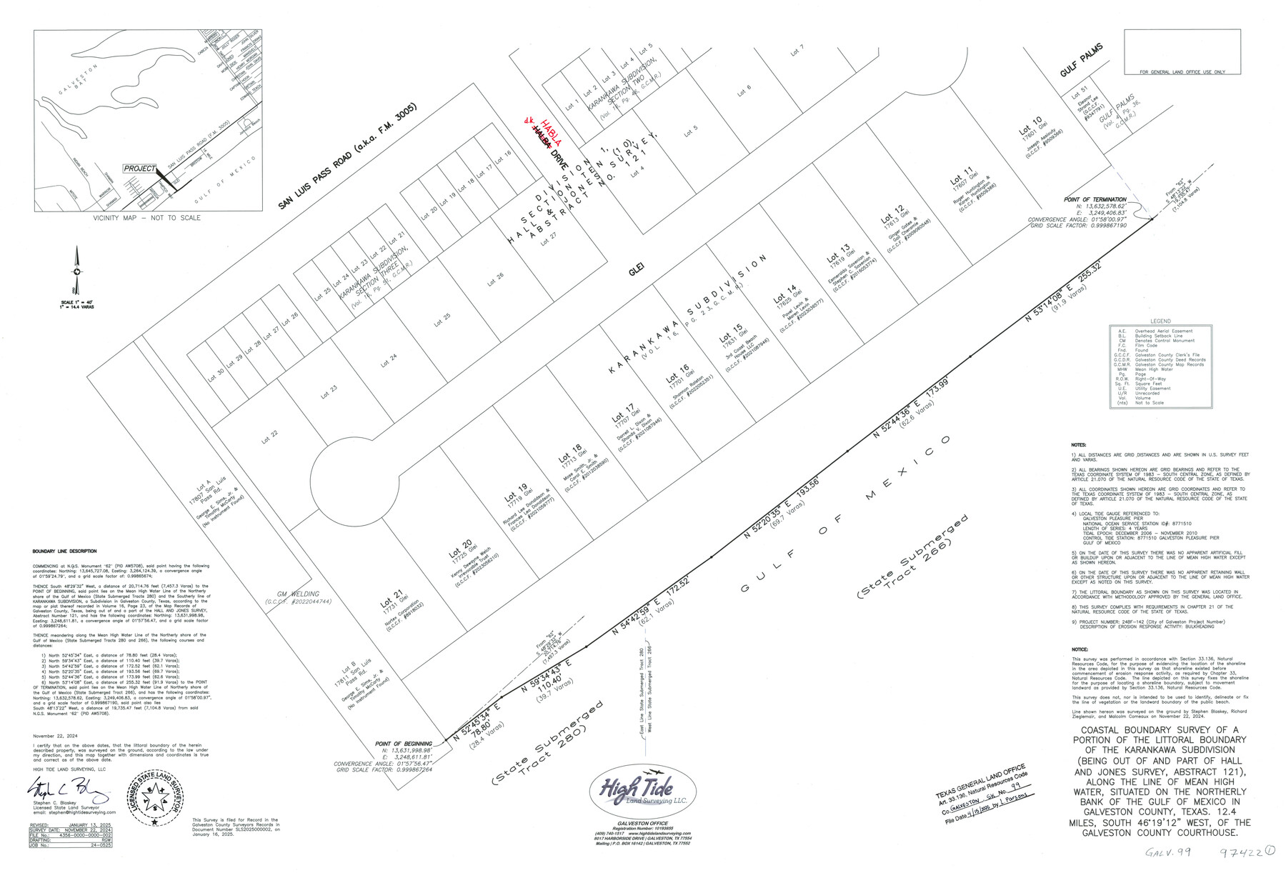
Survey of a portion of the littoral boundary of the Karankawa Subdivision (being out of and part of Hall and Jones Sur., A-121), along the line of mean high water, situated on the northerly bank of the Gulf of Mexico
-
Map/Doc
97422
-
Collection
General Map Collection
-
Object Dates
11/22/2024 (Creation Date)
1/13/2025 (Revision Date)
4/15/2025 (File Date)
-
People and Organizations
Stephen C. Blaskey (Surveyor/Engineer)
-
Counties
Galveston
-
Subjects
Surveying CBS
-
Comments
Project: Karankawa Subdivision Submerged Tract 280, 266, Galveston Co.
This survey is in connection with City of Galveston Project Number 24BF-142, bulkheading for erosion response.
A copy of the survey has been filed under Instrument No. SLS2025000002, Galveston County Surveyors Records.
Part of: General Map Collection
Winkler County

Print $20.00
- Digital $50.00
Winkler County
1901
Size 44.1 x 37.9 inches
Map/Doc 63131
Culberson County Rolled Sketch 52

Print $20.00
- Digital $50.00
Culberson County Rolled Sketch 52
Size 19.1 x 24.7 inches
Map/Doc 5672
Harrison County

Print $20.00
- Digital $50.00
Harrison County
1920
Size 43.8 x 40.8 inches
Map/Doc 95523
Liberty County Sketch File 5b

Print $6.00
- Digital $50.00
Liberty County Sketch File 5b
1857
Size 8.0 x 3.5 inches
Map/Doc 29890
Pecos County Sketch File 67

Print $76.00
- Digital $50.00
Pecos County Sketch File 67
1919
Size 14.1 x 8.8 inches
Map/Doc 33828
Galveston County Sketch File 1b

Print $6.00
- Digital $50.00
Galveston County Sketch File 1b
1845
Size 16.2 x 11.0 inches
Map/Doc 23347
Johnson's New Military Map of the United States Showing the Forts, Military Posts & c. with Enlarged Plans of Southern Harbors

Print $20.00
- Digital $50.00
Johnson's New Military Map of the United States Showing the Forts, Military Posts & c. with Enlarged Plans of Southern Harbors
1863
Size 17.7 x 23.3 inches
Map/Doc 93289
General Chart of the Coast No. XXI Gulf Coast from Galveston to the Rio Grande

Print $20.00
- Digital $50.00
General Chart of the Coast No. XXI Gulf Coast from Galveston to the Rio Grande
1883
Size 27.1 x 18.2 inches
Map/Doc 72730
Approaches to Galveston Bay

Print $40.00
- Digital $50.00
Approaches to Galveston Bay
1992
Size 36.6 x 55.6 inches
Map/Doc 69888
Hunt County Boundary File 3

Print $12.00
- Digital $50.00
Hunt County Boundary File 3
Size 10.5 x 8.4 inches
Map/Doc 55208
United States - Gulf Coast Texas - Northern part of Laguna Madre

Print $20.00
- Digital $50.00
United States - Gulf Coast Texas - Northern part of Laguna Madre
1941
Size 26.7 x 18.3 inches
Map/Doc 72934
Hays County Sketch File 2

Print $4.00
- Digital $50.00
Hays County Sketch File 2
1846
Size 6.3 x 8.1 inches
Map/Doc 26200
You may also like
Ellis County Boundary File 1

Print $10.00
- Digital $50.00
Ellis County Boundary File 1
Size 12.5 x 7.7 inches
Map/Doc 52939
Fort Bend County Sketch File 28

Print $40.00
- Digital $50.00
Fort Bend County Sketch File 28
Size 13.7 x 8.6 inches
Map/Doc 22979
Edwards County Sketch File A1

Print $6.00
- Digital $50.00
Edwards County Sketch File A1
Size 8.5 x 8.8 inches
Map/Doc 21659
Map of Chicago, Rock Island & Texas Railway through Montague and Wise Counties, Texas

Print $20.00
- Digital $50.00
Map of Chicago, Rock Island & Texas Railway through Montague and Wise Counties, Texas
1893
Size 19.0 x 47.6 inches
Map/Doc 64469
Map of Franklin County

Print $20.00
- Digital $50.00
Map of Franklin County
1879
Size 21.1 x 10.4 inches
Map/Doc 3560
Jeff Davis County Rolled Sketch 11

Print $20.00
- Digital $50.00
Jeff Davis County Rolled Sketch 11
1914
Size 17.9 x 14.4 inches
Map/Doc 6364
Flight Mission No. BQR-5K, Frame 63, Brazoria County

Print $20.00
- Digital $50.00
Flight Mission No. BQR-5K, Frame 63, Brazoria County
1952
Size 19.0 x 22.6 inches
Map/Doc 84008

East Part of Liberty Co.

Print $20.00
- Digital $50.00
East Part of Liberty Co.
1977
Size 41.0 x 30.9 inches
Map/Doc 77352
Somervell County Working Sketch Graphic Index

Print $20.00
- Digital $50.00
Somervell County Working Sketch Graphic Index
1941
Size 27.0 x 25.7 inches
Map/Doc 76700
Sutton County Rolled Sketch 61

Print $20.00
- Digital $50.00
Sutton County Rolled Sketch 61
1890
Size 27.8 x 23.4 inches
Map/Doc 7898
Hill County Sketch File 22

Print $8.00
- Digital $50.00
Hill County Sketch File 22
1860
Size 7.7 x 8.2 inches
Map/Doc 26505